
Файл:CPLPmap.png

Памер папярэдняга прагляду: 800 × 370 пікселяў. Іншыя разрозненні: 320 × 148 пікселяў | 640 × 296 пікселяў | 1 357 × 628 пікселяў.
Арыгінальны файл (1 357 × 628 кропак, аб’ём файла: 48 KB, тып MIME: image/png)

|
This linguistic map image could be re-created using vector graphics as an SVG file. This has several advantages; see Commons:Media for cleanup for more information. If an SVG form of this image is available, please upload it and afterwards replace this template with
{{vector version available|new image name}}.
It is recommended to name the SVG file “CPLPmap.svg”—then the template Vector version available (or Vva) does not need the new image name parameter. |
Тлумачэнне
| Апісанне | |||
| Дата | |||
| Крыніца | Own work, based in older version of Image:BlankMap-World.png | ||
| Аўтар | Felipe Fontoura | ||
| Дазвол (Паўторнае выкарыстанне гэтага файла) |
|
||
| Іншыя версіі |
|


| Annotations | This image is annotated: View the annotations at Commons |
Гісторыя файла
Націснуць на даце з часам, каб паказаць файл, якім ён тады быў.
| Дата і час | Драбніца | Памеры | Удзельнік | Тлумачэнне | |
|---|---|---|---|---|---|
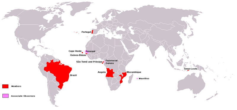
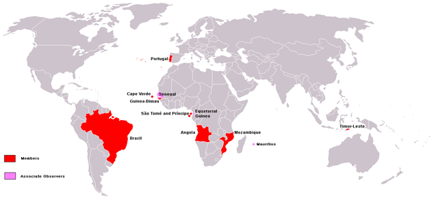
| актуальн. | 18:04, 14 жніўня 2008 | | 1 357 × 628 (48 KB) | The Ogre | Senegal as Associate observer since 2008 |
| 18:02, 14 жніўня 2008 |  | 1 357 × 628 (48 KB) | The Ogre | {{Information |Description= |Source= |Date= |Author= |Permission= |other_versions= }} | |
| 11:46, 9 сакавіка 2008 |  | 1 357 × 628 (30 KB) | Hoshie | fixed Equatorial Guinea, Cabinda (Angola), Guinea-Bissau, and added Montenegro. The name "East Timor" is no longer used. | |
| 23:57, 3 сакавіка 2008 |  | 1 357 × 628 (48 KB) | The Ogre | Corrections of small tweaks - easier to read now | |
| 22:57, 3 сакавіка 2008 |  | 1 357 × 628 (48 KB) | The Ogre | Corrections - see talk of en:Community of Portuguese Language Countries, Equatorial Guinea is just an observer, not a member, added Mauritius as observer, distinguished between observers and members | |
| 03:02, 23 лютага 2008 |  | 1 357 × 628 (47 KB) | The Ogre | Same map - Better visibility and with country names | |
| 00:34, 18 ліпеня 2007 |  | 1 357 × 628 (45 KB) | Domaleixo | {{Information |Description= |Source=atualização do mapa da CPLP, com a adição da Guiné Equatorial |Date=16/07/2007 |Author=Emerson Santiago Silva |Permission= |other_versions= }} | |
| 03:26, 26 чэрвеня 2006 |  | 1 357 × 628 (45 KB) | LipeFontoura | {{Information |Description = Map of the CPLP countries. |Source = own work |Date = 25/06/2006 |Author = |Permission = |other_versions = }} |
Выкарыстанне файла
Наступная 1 старонка выкарыстоўвае гэты файл:
Глабальнае выкарыстанне файла
Гэты файл выкарыстоўваецца ў наступных вікі:
- Выкарыстанне ў als.wikipedia.org
- Выкарыстанне ў ar.wikipedia.org
- Выкарыстанне ў ast.wikipedia.org
- Выкарыстанне ў ba.wikipedia.org
- Выкарыстанне ў bg.wikipedia.org
- Выкарыстанне ў da.wikipedia.org
- Выкарыстанне ў en.wikipedia.org
- Выкарыстанне ў es.wikipedia.org
- Выкарыстанне ў fa.wikipedia.org
- Выкарыстанне ў it.wikipedia.org
- Выкарыстанне ў ja.wikipedia.org
- Выкарыстанне ў ka.wikipedia.org
- Выкарыстанне ў ko.wikipedia.org
- Выкарыстанне ў lb.wikipedia.org
- Выкарыстанне ў lv.wikipedia.org
- Выкарыстанне ў mwl.wikipedia.org
- Выкарыстанне ў nl.wikipedia.org
- Выкарыстанне ў nn.wikipedia.org
- Выкарыстанне ў no.wikipedia.org
- Выкарыстанне ў pt.wikipedia.org
- Выкарыстанне ў pt.wikinews.org
- Выкарыстанне ў pt.wiktionary.org
- Выкарыстанне ў sl.wikipedia.org
- Выкарыстанне ў vi.wikipedia.org
- Выкарыстанне ў zh.wikipedia.org