
Файл:Litauen-regional.png

Арыгінальны файл (3 218 × 2 290 кропак, аб’ём файла: 153 KB, тып MIME: image/png)

|
This locator map image could be re-created using vector graphics as an SVG file. This has several advantages; see Commons:Media for cleanup for more information. If an SVG form of this image is available, please upload it and afterwards replace this template with
{{vector version available|new image name}}.
It is recommended to name the SVG file “Litauen-regional.svg”—then the template Vector version available (or Vva) does not need the new image name parameter. |
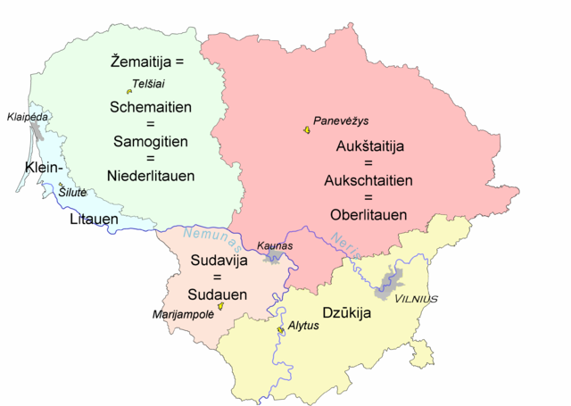
Ethnographic regions of Lithuania within borders of modern Lithuania. Based on map drawn and approved by Council for the Protection of Ethnic Culture (Etninės kultūros globos taryba), a council under Seimas, Lithuanian parliament.
Ethnographic regions of Lithuania are not based on political history or administrative divisions. The regions are based on cultural differences of ordinary people living there.
Names used in German literature, added by Ulamm 10:12, 11 May 2008 (UTC)
Legend:
- Light blue - Lithuania Minor (Mažoji Lietuva)
- Light Green - Samogitia (Žemaitija)
- Pink - Highland (Aukštaitija)
- Yellow - Dainava (Dzūkija)
- Light brown - Sudovia (Suvalkija)
- Yellow cities - unofficial capitals of each region
- Vilnius - capital of Lithuania
Basic version = Image:Liet-etno-regionai.png
| Я, уладальнік аўтарскіх правоў на гэты твор, перадаю яго ў грамадскі набытак. Дазвол сапраўдны для ўсяго свету. У некаторых краінах гэта не можа быць юрыдычна магчыма; калі так, то: Я дазваляю кожнаму выкарыстоўваць гэтую працу ў любых мэтах, без аніякіх умоваў, калі толькі такія ўмовы не патрабуюцца паводле закону. |
Гісторыя файла
Націснуць на даце з часам, каб паказаць файл, якім ён тады быў.
| Дата і час | Драбніца | Памеры | Удзельнік | Тлумачэнне | |
|---|---|---|---|---|---|
| актуальн. | 23:49, 11 мая 2008 | | 3 218 × 2 290 (153 KB) | Ulamm | |
| 13:16, 11 мая 2008 |  | 3 218 × 2 290 (154 KB) | Ulamm | ||
| 13:12, 11 мая 2008 |  | 3 218 × 2 290 (154 KB) | Ulamm | Ethnographic regions of Lithuania within borders of modern Lithuania. Based on [http://www3.lrs.lt/owa-bin/owarepl/inter/owa/U0123191.jpg map] drawn and approved by [http://www3.lrs.lt/pls/inter/w5_show?p_r=877&p_d=35196&p_k=2 Council for the Protection o |
Выкарыстанне файла
Няма старонак, якія выкарыстоўваюць гэты файл.
Глабальнае выкарыстанне файла
Гэты файл выкарыстоўваецца ў наступных вікі:
- Выкарыстанне ў bs.wikipedia.org
- Выкарыстанне ў de.wikipedia.org
- Выкарыстанне ў de.wikivoyage.org
- Выкарыстанне ў lt.wikipedia.org
- Выкарыстанне ў lt.wikibooks.org
- Выкарыстанне ў ru.wikipedia.org
- Выкарыстанне ў sv.wikipedia.org