
Файл:Map of Korean language.png

Памер папярэдняга прагляду: 800 × 351 пікселяў. Іншыя разрозненні: 320 × 140 пікселяў | 640 × 281 пікселяў | 1 425 × 625 пікселяў.
Арыгінальны файл (1 425 × 625 кропак, аб’ём файла: 40 KB, тып MIME: image/png)
| Апісанне |
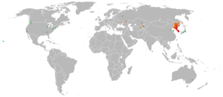
한국어: 한국어 / 조선말의 세계 분포를 나타낸 그림.
English: The map showing usage of Korean language in the world
日本語: 朝鮮語の世界分布図
中文:各國家及地區的朝鮮语使用者分布图
Tiếng Việt: Bản đồ phân bố người sự dụng tiếng Triều Tiên ở các Quốc gia và Vùng lãnh thổ.
|
||
| Крыніца | modified Image:BlankMap-World.png | ||
| Аўтар | created by LERK | ||
| Дазвол (Паўторнае выкарыстанне гэтага файла) |
|
||
| Іншыя версіі |
|

Гісторыя файла
Націснуць на даце з часам, каб паказаць файл, якім ён тады быў.
| Дата і час | Драбніца | Памеры | Удзельнік | Тлумачэнне | |
|---|---|---|---|---|---|
| актуальн. | 04:36, 29 мая 2021 | | 1 425 × 625 (40 KB) | Ecthelion83 | previous upload did not seem to actually update the map as intended |
| 04:35, 29 мая 2021 |  | 1 425 × 625 (40 KB) | Ecthelion83 | Reverted to version as of 18:10, 9 December 2019 (UTC) | |
| 04:29, 29 мая 2021 |  | 1 425 × 625 (40 KB) | Ecthelion83 | includes major US metro areas of Atlanta, Chicago, New York, Washington DC, and Seattle, all of which have Korean populations that exceed those of the already-included Canadian metro areas with Korean populations | |
| 21:10, 9 снежня 2019 |  | 1 425 × 625 (40 KB) | LenguaMapa | added koryo-saram, corrections | |
| 23:49, 15 чэрвеня 2011 |  | 1 425 × 625 (56 KB) | Shibo77 | orange | |
| 00:07, 26 лістапада 2009 |  | 1 425 × 625 (32 KB) | Shibo77 | .. | |
| 09:40, 12 лютага 2008 |  | 1 425 × 625 (18 KB) | LERK | {{Information |Description= {{ko|한국어 / 조선말의 세계 분포를 나타낸 그림. * 빨강색: 대다수 원어민이 거주하는 지역 * 주황색: 공용어로서 사용되는 지역 * 녹색: 소수 민족으로서 원어민이 거주하� |
Выкарыстанне файла
Наступная 1 старонка выкарыстоўвае гэты файл:
Глабальнае выкарыстанне файла
Гэты файл выкарыстоўваецца ў наступных вікі:
- Выкарыстанне ў ar.wikipedia.org
- Выкарыстанне ў arz.wikipedia.org
- Выкарыстанне ў ast.wikipedia.org
- Выкарыстанне ў as.wikipedia.org
- Выкарыстанне ў ban.wikipedia.org
- Выкарыстанне ў ba.wikipedia.org
- Выкарыстанне ў bcl.wikipedia.org
- Выкарыстанне ў be-tarask.wikipedia.org
- Выкарыстанне ў beta.wikiversity.org
- Выкарыстанне ў bn.wikipedia.org
- Выкарыстанне ў bxr.wikipedia.org
- Выкарыстанне ў ca.wikipedia.org
- Выкарыстанне ў ca.wiktionary.org
- Выкарыстанне ў ceb.wikipedia.org
- Выкарыстанне ў ckb.wikipedia.org
- Выкарыстанне ў cs.wikipedia.org
- Выкарыстанне ў el.wikipedia.org
- Выкарыстанне ў eo.wikipedia.org
- Выкарыстанне ў fa.wikipedia.org
- Выкарыстанне ў fiu-vro.wikipedia.org
- Выкарыстанне ў ga.wikipedia.org
- Выкарыстанне ў gl.wikipedia.org
- Выкарыстанне ў hak.wikipedia.org
- Выкарыстанне ў hif.wikipedia.org
- Выкарыстанне ў hi.wikipedia.org
- Выкарыстанне ў hu.wikipedia.org
- Выкарыстанне ў hy.wikipedia.org
- Выкарыстанне ў ia.wikipedia.org
- Выкарыстанне ў ilo.wikipedia.org
- Выкарыстанне ў incubator.wikimedia.org
- Выкарыстанне ў it.wikipedia.org
- Выкарыстанне ў it.wikivoyage.org
- Выкарыстанне ў iu.wikipedia.org
- Выкарыстанне ў kk.wikipedia.org
- Выкарыстанне ў ko.wikipedia.org
- Выкарыстанне ў ko.wiktionary.org
- Выкарыстанне ў kv.wikipedia.org
- Выкарыстанне ў ml.wikipedia.org
- Выкарыстанне ў mn.wikipedia.org
- Выкарыстанне ў my.wikipedia.org
- Выкарыстанне ў mzn.wikipedia.org
- Выкарыстанне ў ne.wikipedia.org
- Выкарыстанне ў new.wikipedia.org
- Выкарыстанне ў no.wikipedia.org
- Выкарыстанне ў oc.wikipedia.org
- Выкарыстанне ў pam.wikipedia.org
- Выкарыстанне ў pa.wikipedia.org
Паказаць глабальнае выкарыстанне гэтага файла.