
Файл:Nansen Fram Map rus.png
Памер папярэдняга прагляду: 800 × 479 пікселяў. Іншыя разрозненні: 320 × 192 пікселяў | 640 × 383 пікселяў | 1 003 × 601 пікселяў.
Арыгінальны файл (1 003 × 601 кропак, аб’ём файла: 84 KB, тып MIME: image/png)
| Апісанне |
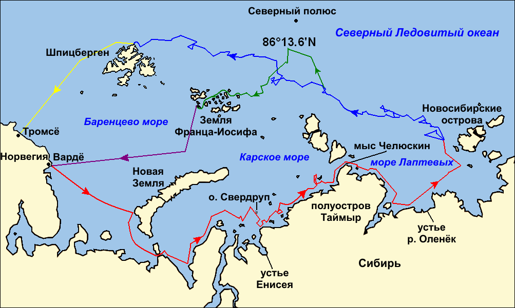
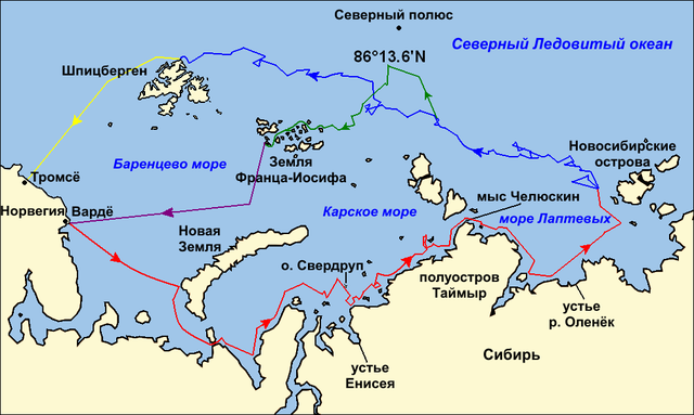
Map of the Arctic Ocean showing the routes taken during the 1893–96 Nansen's Fram expedition: Frams's route eastward from Vardø to the Siberian coast, turning north at the New Siberian Islands to enter the pack ice. July – September 1893 Fram's drift in the ice from the New Siberian Islands, north and west to Spitsbergen, September 1893 – August 1896 Nansen and Johansen's march to Farthest North, 80°20'N, and their subsequent retreat to Cape Flora in Franz Josef Land. February 1895 – June 1896 Nansen and Johansen's return to Vardø from Cape Flora, August 1896 Fram's voyage from Spitsbergen to Tromsø, August 1896 |
| Дата | (UTC) |
| Крыніца | |
| Аўтар |
|
| Іншыя версіі |
|

| This is a retouched picture, which means that it has been digitally altered from its original version. Modifications: текст на русском языке (russian text). The original can be viewed here: Nansen Fram Map.png:
|
Я, уладальнік аўтарскіх правоў на гэты твор, добраахвотна публікую яго на ўмовах наступных ліцэнзій:
Гэты файл даступны па ліцэнзіям Creative Commons Пазначэнне аўтарства - На тых самых умовах 3.0 Непартаваная, 2.5 Агульны, 2.0 Агульны і 1.0 Агульны.
- Вы можаце свабодна:
- дзяліцца творам – капіраваць, распаўсюджваць і перадаваць гэты твор.
- ствараць вытворныя творы – адаптаваць гэты твор
- Пры выкананні наступных умоў:
- атрыбуцыя – вы павінны пазначыць аўтарства гэтага твора, даць спасылку на ліцэнзію і пазначыць ці рабіў аўтар якія-небудзь змены. Гэта можна рабіць кожным зразумелым чынам, але не так, каб наводзіць па думку, што ліцэнзіят падтрымлівае вас або выкарыстанне вамі гэтага твора.
- распаўсюджванне на тых жа ўмовах – Калі вы змяняеце, адаптуеце ці ствараеце вытворны твор на аснове гэтага, то павінны распаўсюджваць атрыманы ў выніку твор на ўмовах такой самай ці сумяшчальнай ліцэнзіі, што і арыгінал.

|
Дазваляецца капіяваць, распаўсюджваць і(або) мадыфікаваць гэты дакумент на ўмовах ліцэнзіі GNU FDL версіі 1.2 або навейшай, выдадзенай Фондам свабоднага праграмнага забеспячэння; без Нязменных раздзелаў, без тэкстаў Вокладак. Копія ліцэнзіі ёсць у раздзеле GNU Free Documentation License. |
Вы можаце выбраць любую з гэтых ліцэнзій.
Журнал арыгінальнай загрузкі
This image is a derivative work of the following images:
- File:Nansen_Fram_Map.png licensed with Cc-by-sa-3.0,2.5,2.0,1.0, GFDL
- 2009-10-21T15:50:57Z Ruhrfisch 1003x601 (79935 Bytes) Make arrowheads less triangular (indentations at rear)
- 2009-10-21T15:23:20Z Ruhrfisch 1003x601 (79868 Bytes) Add arrowheads per FAC
- 2009-10-20T18:50:18Z Ruhrfisch 1003x601 (79825 Bytes) Make magenta line purple
- 2009-10-11T13:36:40Z Ruhrfisch 1003x601 (79831 Bytes) Yellow line for orange, some labels smaller, Farthest North replaced with actual figure, all other info the same
- 2009-10-11T03:08:59Z Ruhrfisch 1003x601 (81994 Bytes) Darker green for that line, all other information is the same
- 2009-10-11T02:46:31Z Ruhrfisch 1003x601 (81987 Bytes) Added last two lines for ice voyages, added last labels, all other information the same.
- 2009-10-09T19:30:04Z Ruhrfisch 1003x601 (75047 Bytes) Add labels, two more voyage lines, all other information is the same
- 2009-10-09T16:12:36Z Ruhrfisch 1003x601 (57897 Bytes) == Summary == {{Information |Description = Map of the Arctic Ocean showing the path of [[w:Nansen's Fram expedition|Nansen's Fram expedition]] 1893 to 1896 |Source = Base map of European mainland is from [[:File:Ma
Uploaded with derivativeFX
Гісторыя файла
Націснуць на даце з часам, каб паказаць файл, якім ён тады быў.
| Дата і час | Драбніца | Памеры | Удзельнік | Тлумачэнне | |
|---|---|---|---|---|---|
| актуальн. | 02:06, 9 студзеня 2011 | | 1 003 × 601 (84 KB) | Ivengo(RUS) | {{Information |Description=Map of the Arctic Ocean showing the routes taken during the 1893–96 Nansen's Fram expedition: {{legend|red|Frams's route eastward from Vardø to the Siberian coast, turning north at the New Sibe |
Выкарыстанне файла
Наступныя 2 старонкі выкарыстоўваюць гэты файл:
Глабальнае выкарыстанне файла
Гэты файл выкарыстоўваецца ў наступных вікі:
- Выкарыстанне ў ba.wikipedia.org
- Выкарыстанне ў bg.wikipedia.org
- Выкарыстанне ў hy.wikipedia.org
- Выкарыстанне ў kk.wikipedia.org
- Выкарыстанне ў ru.wikipedia.org
- Выкарыстанне ў uk.wikipedia.org