
Файл:Nseamap.gif
Няма версіі з большай раздзяляльнасцю.
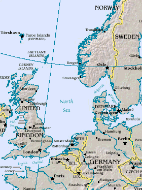
Nseamap.gif (280 × 374 кропак, аб’ём файла: 43 KB, тып MIME: image/gif)
Map of North Sea, from the US Department of Energy: http://eia.doe.gov/emeu/cabs/northsea.html
Русский: Северное море
| This image is a work of a United States Department of Energy (or predecessor organization) employee, taken or made as part of that person's official duties. As a work of the U.S. federal government, the image is in the public domain.
Please note that national laboratories operate under varying licences and some are not free. Check the site policies of any national lab before crediting it with this tag.
|

|
Гісторыя файла
Націснуць на даце з часам, каб паказаць файл, якім ён тады быў.
| Дата і час | Драбніца | Памеры | Удзельнік | Тлумачэнне | |
|---|---|---|---|---|---|
| актуальн. | 17:20, 26 сакавіка 2005 | | 280 × 374 (43 KB) | Ivan~commonswiki | Map of North Sea, from the en:US Department of Energy: [http://eia.doe.gov/emeu/cabs/northsea.html http://eia.doe.gov/emeu/cabs/northsea.html] {{PD-USGov}} |
Выкарыстанне файла
Няма старонак, якія выкарыстоўваюць гэты файл.
Глабальнае выкарыстанне файла
Гэты файл выкарыстоўваецца ў наступных вікі:
- Выкарыстанне ў als.wikipedia.org
- Выкарыстанне ў am.wikipedia.org
- Выкарыстанне ў ast.wikipedia.org
- Выкарыстанне ў as.wikipedia.org
- Выкарыстанне ў ban.wikipedia.org
- Выкарыстанне ў ba.wikipedia.org
- Выкарыстанне ў be-tarask.wikipedia.org
- Выкарыстанне ў csb.wikipedia.org
- Выкарыстанне ў cv.wikipedia.org
- Выкарыстанне ў da.wikipedia.org
- Выкарыстанне ў de.wiktionary.org
- Выкарыстанне ў diq.wikipedia.org
- Выкарыстанне ў en.wikipedia.org
- Выкарыстанне ў eo.wikipedia.org
- Выкарыстанне ў gl.wikipedia.org
- Выкарыстанне ў he.wikipedia.org
- Выкарыстанне ў hif.wikipedia.org
- Выкарыстанне ў hr.wikipedia.org
- Выкарыстанне ў hu.wiktionary.org
- Выкарыстанне ў id.wikipedia.org
- Выкарыстанне ў is.wikipedia.org
- Выкарыстанне ў it.wikipedia.org
- Выкарыстанне ў it.wikibooks.org
- Выкарыстанне ў ja.wikipedia.org
- Выкарыстанне ў jv.wikipedia.org
- Выкарыстанне ў ka.wikipedia.org
- Выкарыстанне ў kw.wikipedia.org
- Выкарыстанне ў lij.wikipedia.org
- Выкарыстанне ў lt.wikipedia.org
- Выкарыстанне ў ml.wikipedia.org
- Выкарыстанне ў mn.wikipedia.org
- Выкарыстанне ў mwl.wikipedia.org
- Выкарыстанне ў nn.wikipedia.org
- Выкарыстанне ў olo.wikipedia.org
- Выкарыстанне ў pl.wiktionary.org
- Выкарыстанне ў pt.wikipedia.org
- Выкарыстанне ў roa-tara.wikipedia.org
- Выкарыстанне ў ru.wikipedia.org
- Выкарыстанне ў ru.wiktionary.org
- Выкарыстанне ў sah.wikipedia.org
- Выкарыстанне ў sco.wikipedia.org
- Выкарыстанне ў simple.wikipedia.org
Паказаць глабальнае выкарыстанне гэтага файла.