Файл:Ocean drainage.png
Змест старонкі недаступны на іншых мовах.
З Вікіпедыі, свабоднай энцыклапедыі

Арыгінальны файл(1 256 × 656 кропак, аб’ём файла: 75 KB, тып MIME: image/png)

Гэты файл з на Вікісховішчы і можа выкарыстоўвацца іншымі праектамі. Апісанне на яго старонцы ў Wikimedia Commons прыведзена ніжэй.

Тлумачэнне

This map image could be re-created using vector graphics as an SVG file. This has several advantages; see Commons:Media for cleanup for more information. If an SVG form of this image is available, please upload it and afterwards replace this template with {{vector version available|new image name}}.


It is recommended to name the SVG file “Ocean drainage.svg”—then the template Vector version available (or Vva) does not need the new image name parameter.
Апісанне
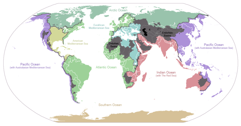
English: I made this map and hereby release it into the public domain. It shows the drainage basins for the major oceans and seas; grey areas are endorheic basins that do not drain to the ocean. Data is from the USGS Hydro1k project; information for Saskatchewan corrected by information from the Commission for Environmental Cooperation -- Citynoise
Description in large font size is used for oceans, in smaller font size is used for mediterranean seas. Only these mediterranean seas are listed which correspond to the definition of german Geographer Ernst Neef: A mediterranean sea is a sea between two Continents. Also found here: de:Mittelmeer --W like wiki (talk) 00:55, 12 March 2011 (UTC)
Français : Carte du monde des bassins versants. Les zones de couleur anthracite représentent les bassins endoréiques, qui ne sont reliés à aucun océan.
Čeština: Úmoří světových oceánů, popř. významných moří či zálivů. Legenda úmoří: fialová - Tichý oceán, růžová - Indický oceán, zelená - Atlantický oceán, azurová - Severní ledový oceán, béžová - Jižní oceán, modrá - Mexický záliv, světle modrá - Středozemní moře, šedá - oblast neústící ve světovém oceánu
Дата 24 студзеня 2007 (original upload date)
Крыніца Transferred from en.wikipedia to Commons.
Аўтар Citynoise at англійская Вікіпедыя
Іншыя версіі File:Major endorheic basins.png

Ліцэнзіяванне

Public domain Гэты твор быў перададзены ў грамадскі набытак яго аутарам, Citynoise at англійская Вікіпедыя. Дазвол сапраўдны для ўсяго свету.
У некаторых краінах гэта не можа быць юрыдычна магчыма; калі так, то:
Citynoise дазваляе кожнаму выкарыстоўваць гэты твор ў любых мэтах, без аніякіх умоваў, калі толькі такія ўмовы не патрабуюцца паводле закону.

Журнал арыгінальнай загрузкі

The original description page was here. All following user names refer to en.wikipedia.
  • 2007-05-20 17:59 Bolonium 1256×656×8 (50194 bytes) I made this map and hereby release it into the public domain. It shows the drainage basins for the major oceans and seas; grey areas are endorheic basins that do not drain to the ocean. -- [[User:Citynoise|Citynoise]] == Licensing == {{self
  • 2007-01-24 07:21 Citynoise 1256×656×8 (63359 bytes) I made this map and hereby release it into the public domain. It shows the drainage basins for the major oceans and seas; grey areas are endorheic basins that do not drain to the ocean.
  • 2007-01-24 06:09 Citynoise 1256×656×8 (57358 bytes) I made this map and hereby release it into the public domain. It shows the drainage basins for the major oceans and seas; grey areas are endorheic basins that do not drain to the ocean.
  • 2007-01-24 05:10 Citynoise 1256×656×8 (56360 bytes) I made this map and hereby release it into the public domain. It shows the drainage basins for the major oceans and seas; grey areas are endorheic basins that do not drain to the ocean.
  • 2007-01-24 04:55 Citynoise 1256×656×8 (56373 bytes) I made this map and hereby release it into the public domain. It shows the drainage basins for the major oceans and seas; grey areas are endorheic basins that do not drain to the ocean.

Назвы

Апішыце ў адным радку, што ўяўляе сабой гэты файл
Drainage basins of the world, colored by ocean outlet. Endorheic basins not draining to an ocean are colored dark gray. Continental divides are indicated by dark lines.

Элементы, адлюстраваныя на гэтым файле

адлюстроўвае

Гісторыя файла

Націснуць на даце з часам, каб паказаць файл, якім ён тады быў.

Дата і часДрабніцаПамерыУдзельнікТлумачэнне
актуальн.02:25, 7 кастрычніка 2015Драбніца версіі з 02:25, 7 кастрычніка 20151 256 × 656 (75 KB)AcidSnowFixed Somalia.
03:39, 12 сакавіка 2011Драбніца версіі з 03:39, 12 сакавіка 20111 256 × 656 (76 KB)W like wikiInsert Description. Big font size is used for oceans, smaller font size is used for mediterranean seas.
14:13, 30 чэрвеня 2009Драбніца версіі з 14:13, 30 чэрвеня 20091 256 × 656 (40 KB)U7vGuntransparentize background,improve some details.
23:45, 26 ліпеня 2008Драбніца версіі з 23:45, 26 ліпеня 20081 256 × 656 (62 KB)Citynoise{{Information |Description=added endorheic basins in Saskatchewan. |Source=my own work |Date=July 2008 |Author=Citynoise |Permission=all rights released |other_versions= }}
22:46, 27 лістапада 2007Драбніца версіі з 22:46, 27 лістапада 20071 256 × 656 (49 KB)File Upload Bot (Magnus Manske) {{BotMoveToCommons|en.wikipedia}} {{Information |Description={{en|I made this map and hereby release it into the public domain. It shows the drainage basins for the major oceans and seas; grey areas are en:endorheic basins that do not drain to the

Наступныя 2 старонкі выкарыстоўваюць гэты файл:

Глабальнае выкарыстанне файла

Гэты файл выкарыстоўваецца ў наступных вікі:

Паказаць глабальнае выкарыстанне гэтага файла.

Метаданыя