
Файл:USA Territorial Growth small.gif
Няма версіі з большай раздзяляльнасцю.
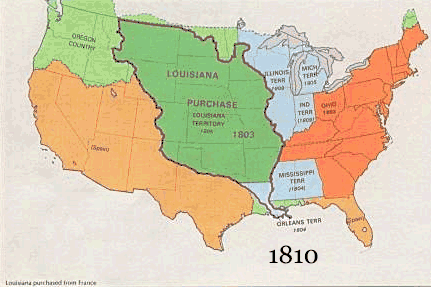
USA_Territorial_Growth_small.gif (431 × 287 кропак, аб’ём файла: 456 KB, тып MIME: image/gif, закальцаваныя, 10 кадраў, 30 s)

|
This file has been superseded by USA territorial growth.gif. It is recommended to use the other file. Please note that deleting superseded images requires consent.
|

|
Тлумачэнне
| Апісанне |
English: US territorial growth 1810–1920, based on the PD USGS maps in Category:Territorial growth maps of the United States.
See key below for explanation of colors.  |
||||||
| Крыніца |
|
||||||
| Аўтар |
|
||||||
| Іншыя версіі |
|
Ліцэнзіяванне
This image is in the public domain in the United States because it only contains materials that originally came from the United States Geological Survey, an agency of the United States Department of the Interior. For more information, see the official USGS copyright policy.
|
Гісторыя файла
Націснуць на даце з часам, каб паказаць файл, якім ён тады быў.
| Дата і час | Драбніца | Памеры | Удзельнік | Тлумачэнне | |
|---|---|---|---|---|---|
| актуальн. | 13:50, 30 мая 2006 | | 431 × 287 (456 KB) | Roke~commonswiki | US territorial growth, based on the PD USGS maps in Category:USA Territorial Growth Maps Category: USA Territorial Growth Maps {{PD-USGov-USGS}} |
Выкарыстанне файла
Наступныя 2 старонкі выкарыстоўваюць гэты файл:
Глабальнае выкарыстанне файла
Гэты файл выкарыстоўваецца ў наступных вікі:
- Выкарыстанне ў ar.wikipedia.org
- Выкарыстанне ў be-tarask.wikipedia.org
- Выкарыстанне ў ca.wikipedia.org
- Выкарыстанне ў ckb.wikipedia.org
- Выкарыстанне ў da.wikipedia.org
- Выкарыстанне ў fr.wikipedia.org
- Выкарыстанне ў fy.wikipedia.org
- Выкарыстанне ў gcr.wikipedia.org
- Выкарыстанне ў hr.wikipedia.org
- Выкарыстанне ў id.wikipedia.org
- Выкарыстанне ў it.wikipedia.org
- Выкарыстанне ў jv.wikipedia.org
- Выкарыстанне ў kk.wikipedia.org
- Выкарыстанне ў ro.wikipedia.org
- Выкарыстанне ў sh.wikipedia.org
- Выкарыстанне ў sl.wikipedia.org
- Выкарыстанне ў sr.wikipedia.org
- Выкарыстанне ў tr.wikipedia.org
- Выкарыстанне ў uk.wikipedia.org