
Файл:Bay Area by Sentinel-2, 2019-03-11 (small version).jpg

Арыгінальны файл (10 200 × 10 776 кропак, аб’ём файла: 123,14 MB, тып MIME: image/jpeg)
Тлумачэнне
| Warning | The original file is very high-resolution. It might not load properly or could cause your browser to freeze when opened at full size. |
|---|
| Апісанне |
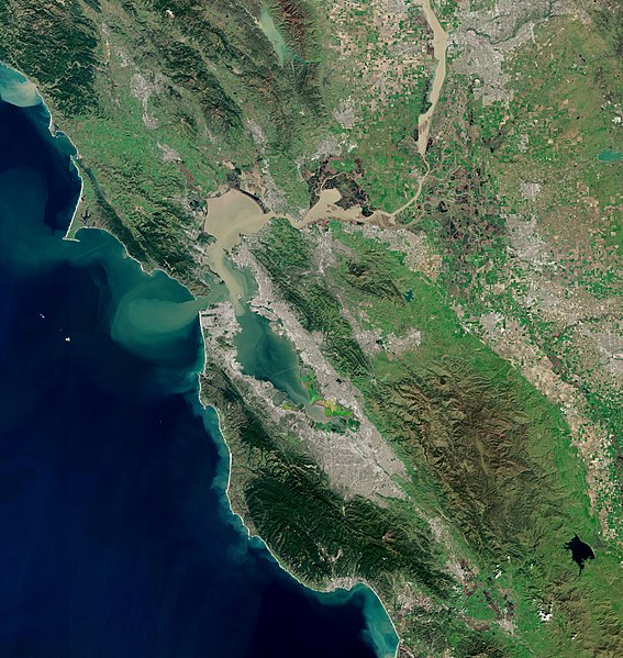
English: Date: 2019-03-11 San Francisco Bay, Mount Tamalpais coast, Santa Cruz Mountains
Sensor: MSI on Sentinel-2A Resolution: 20m (Downsampled) RGB Composites: True color, Band 4-3-2 |
| Дата | |
| Крыніца | https://scihub.copernicus.eu/dhus/#/home |
| Аўтар | Copernicus Sentinel-2, ESA |
| Іншыя версіі |
San Francisco Bay Area
|

.jpg)


.jpg)
Ліцэнзіяванне
- Вы можаце свабодна:
- дзяліцца творам – капіраваць, распаўсюджваць і перадаваць гэты твор.
- ствараць вытворныя творы – адаптаваць гэты твор
- Пры выкананні наступных умоў:
- атрыбуцыя – вы павінны пазначыць аўтарства гэтага твора, даць спасылку на ліцэнзію і пазначыць ці рабіў аўтар якія-небудзь змены. Гэта можна рабіць кожным зразумелым чынам, але не так, каб наводзіць па думку, што ліцэнзіят падтрымлівае вас або выкарыстанне вамі гэтага твора.
- распаўсюджванне на тых жа ўмовах – Калі вы змяняеце, адаптуеце ці ствараеце вытворны твор на аснове гэтага, то павінны распаўсюджваць атрыманы ў выніку твор на ўмовах такой самай ці сумяшчальнай ліцэнзіі, што і арыгінал.

|
This image contains data from a satellite in the Copernicus Programme, such as Sentinel-1, Sentinel-2 or Sentinel-3. Attribution is required when using this image.
Пазначэнне аўтарства: Contains modified Copernicus Sentinel data 2019
The use of Copernicus Sentinel Data is regulated under EU law (Commission Delegated Regulation (EU) No 1159/2013 and Regulation (EU) No 377/2014). Relevant excerpts:
Free access shall be given to GMES dedicated data [...] made available through GMES dissemination platforms [...].
Access to GMES dedicated data [...] shall be given for the purpose of the following use in so far as it is lawful:
GMES dedicated data [...] may be used worldwide without limitations in time.
GMES dedicated data and GMES service information are provided to users without any express or implied warranty, including as regards quality and suitability for any purpose. |
| Annotations | This image is annotated: View the annotations at Commons |
Гісторыя файла
Націснуць на даце з часам, каб паказаць файл, якім ён тады быў.
| Дата і час | Драбніца | Памеры | Удзельнік | Тлумачэнне | |
|---|---|---|---|---|---|
| актуальн. | 17:08, 12 красавіка 2020 | | 10 200 × 10 776 (123,14 MB) | Satview | Uploaded a work by Copernicus Sentinel-2, ESA from https://scihub.copernicus.eu/dhus/#/home with UploadWizard |
Выкарыстанне файла
Наступная 1 старонка выкарыстоўвае гэты файл:
Глабальнае выкарыстанне файла
Гэты файл выкарыстоўваецца ў наступных вікі:
- Выкарыстанне ў ang.wikipedia.org
- Выкарыстанне ў ar.wikipedia.org
- Выкарыстанне ў arz.wikipedia.org
- Выкарыстанне ў ast.wikipedia.org
- Выкарыстанне ў az.wikipedia.org
- Выкарыстанне ў ca.wikipedia.org
- Выкарыстанне ў cy.wikipedia.org
- Выкарыстанне ў de.wikipedia.org
- Выкарыстанне ў de.wikivoyage.org
- Выкарыстанне ў diq.wikipedia.org
- Выкарыстанне ў en.wikipedia.org
- Выкарыстанне ў en.wikivoyage.org
- Выкарыстанне ў eo.wikipedia.org
- Выкарыстанне ў es.wikipedia.org
- Выкарыстанне ў eu.wikipedia.org
- Выкарыстанне ў fy.wikipedia.org
- Выкарыстанне ў ga.wikipedia.org
- Выкарыстанне ў he.wikipedia.org
- Выкарыстанне ў hu.wikipedia.org
- Выкарыстанне ў hy.wikipedia.org
- Выкарыстанне ў ko.wikipedia.org
- Выкарыстанне ў nn.wikipedia.org
- Выкарыстанне ў no.wikipedia.org
- Выкарыстанне ў pt.wikipedia.org
- Выкарыстанне ў ro.wikipedia.org
- Выкарыстанне ў simple.wikipedia.org
- Выкарыстанне ў th.wikipedia.org
- Выкарыстанне ў tr.wikipedia.org
- Выкарыстанне ў uk.wikipedia.org
- Выкарыстанне ў war.wikipedia.org
- Выкарыстанне ў www.wikidata.org
.jpg)