
Файл:Biot-map.png

Няма версіі з большай раздзяляльнасцю.
Biot-map.png (328 × 353 кропак, аб’ём файла: 5 KB, тып MIME: image/png)

|
This map image could be re-created using vector graphics as an SVG file. This has several advantages; see Commons:Media for cleanup for more information. If an SVG form of this image is available, please upload it and afterwards replace this template with
{{vector version available|new image name}}.
It is recommended to name the SVG file “Biot-map.svg”—then the template Vector version available (or Vva) does not need the new image name parameter. |
Transferred from en.wikipedia to Commons by Maksim.
The original description page was here. All following user names refer to en.wikipedia.
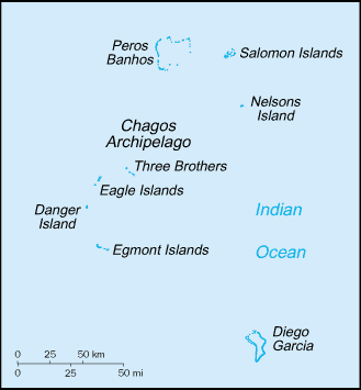
Map of the British Indian Ocean Territory from CIA World Factbook.
This image is in the public domain because it contains materials that originally came from the United States Central Intelligence Agency's World Factbook.
|
 |
| date/time | username | edit summary |
|---|---|---|
| 22:56, 12 November 2004 | en:User:BrokenSegue | ({{PD-USGov-CIA-WF}}) |
| 06:17, 4 June 2004 | en:User:Template namespace initialisation script | |
| 20:15, 23 May 2004 | en:User:Grendelkhan | (clear up PD message) |
| 20:14, 23 May 2004 | en:User:Grendelkhan | (Map of the British Indian Ocean Territory from [http://www.lib.utexas.edu/maps/cia03/british_indian_ocean_sm03.gif CIA World Factbook].<br><br>{{msg:PD}}) |
Журнал арыгінальнай загрузкі
Legend: (cur) = this is the current file, (del) = delete this old version, (rev) = revert to this old version.
Click on date to download the file or see the image uploaded on that date.
- (del) (cur) 22:14, 24 May 2005 . . en:User:Hoshie Hoshie ( en:User_talk:Hoshie Talk) . . 328x353 (4977 bytes) (updated map from 2005 CIA World Factbook, now with a lowercase file name.)
- (del) (rev) 20:14, 23 May 2004 . . en:User:Grendelkhan Grendelkhan ( en:User_talk:Grendelkhan Talk) . . 329x355 (4794 bytes) (Map of the British Indian Ocean Territory from CIA World Factbook.<br><br>{ { msg:PD } })
Гісторыя файла
Націснуць на даце з часам, каб паказаць файл, якім ён тады быў.
| Дата і час | Драбніца | Памеры | Удзельнік | Тлумачэнне | |
|---|---|---|---|---|---|
| актуальн. | 00:11, 13 мая 2006 | | 328 × 353 (5 KB) | Frankie Roberto~commonswiki | Map of the British Indian Ocean Territory from [http://www.lib.utexas.edu/maps/cia03/british_indian_ocean_sm03.gif CIA World Factbook]. {{PD-USGov-CIA-WF}} (copied from http://en.wikipedia.org/wiki/Image:Biot-map.png for use on Wikinews) |
| 14:13, 26 сакавіка 2006 |  | 328 × 353 (5 KB) | Maksim | La bildo estas kopiita de wikipedia:en. La originala priskribo estas: Map of the British Indian Ocean Territory from [http://www.lib.utexas.edu/maps/cia03/british_indian_ocean_sm03.gif CIA World Factbook]. {{PD-USGov-CIA-WF}} {| border="1" ! date/time |
Выкарыстанне файла
Няма старонак, якія выкарыстоўваюць гэты файл.
Глабальнае выкарыстанне файла
Гэты файл выкарыстоўваецца ў наступных вікі:
- Выкарыстанне ў af.wikipedia.org
- Выкарыстанне ў arz.wikipedia.org
- Выкарыстанне ў ast.wikipedia.org
- Выкарыстанне ў bs.wikipedia.org
- Выкарыстанне ў ca.wikipedia.org
- Выкарыстанне ў da.wikipedia.org
- Выкарыстанне ў de.wikipedia.org
- Выкарыстанне ў el.wikipedia.org
- Выкарыстанне ў en.wikipedia.org
- Выкарыстанне ў en.wikinews.org
- Выкарыстанне ў eo.wikipedia.org
- Выкарыстанне ў es.wikipedia.org
- Выкарыстанне ў fa.wikipedia.org
- Выкарыстанне ў fr.wikipedia.org
- Выкарыстанне ў ga.wikipedia.org
- Выкарыстанне ў gl.wikipedia.org
- Выкарыстанне ў hr.wikipedia.org
- Выкарыстанне ў hu.wikipedia.org
- Выкарыстанне ў incubator.wikimedia.org
- Выкарыстанне ў it.wikipedia.org
- Выкарыстанне ў ja.wikipedia.org
- Выкарыстанне ў ko.wikipedia.org
- Выкарыстанне ў lij.wikipedia.org
- Выкарыстанне ў lt.wikipedia.org
- Выкарыстанне ў mzn.wikipedia.org
- Выкарыстанне ў nl.wikipedia.org
- Выкарыстанне ў pl.wikipedia.org
- Выкарыстанне ў pt.wikipedia.org
- Выкарыстанне ў ro.wikipedia.org
Паказаць глабальнае выкарыстанне гэтага файла.