
Файл:Carte la plus generale et qui comprend la Chine, la Tartarie Chinoise, et le Thibet (1734).jpg

Арыгінальны файл (3 000 × 2 106 кропак, аб’ём файла: 3,14 MB, тып MIME: image/jpeg)
Тлумачэнне
| Апісанне |
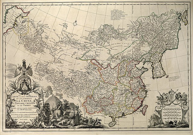
Français : Carte la plus generale et qui comprend la Chine, la Tartarie Chinoise, et le Thibet. Dressee sur les cartes particuliers des RR PP Jesuites, par le Sr. d'Anville..., qui ya joint le pays compris entre Kashgar et la mar Caspienne, tire des geographes et des historiens orientaux
English: A most general map, including China, Chinese Tartary, and Tibet, based on individual maps of the Jesuit fathers. The map gives 1734 as the year, but the modern HKUST publishers say 1737
English: Entire map
"D’Anville’s maps of China were based on a survey of the Chinese empire that was ordered by the emperor in 1708 and carried out by the Chinese, but under the supervision of Jesuit priests resident in China. The detail about the interior of China was far superior to any previous Western map or atlas. D’Anville’s work remained a standard Western source for the geography of China and adjacent regions until well into the 19th century, when it finally was superseded by more accurate maps." — (World Digital Library) 中文:清廷于1708年组织在华法国传教士蒋友仁等进行大规模大地测量,以经纬为基础,测绘编成《皇兴全览图》。该图编成后,被视为珍秘,秘藏大内,而其资料宝已流入欧洲,法国皇家地理官唐维尔(D’anville)编辑,于1737年将皇兴全览图出版,经增补修订,改名《中国新地图集》即此书。故此书是康熙时中国大地测量后最早公开的成果,包括彩印总图两幅,分省图十五幅,边外二十五幅,计42幅。此书羊此装,纸张为带徽记的水印纸印刷。 |
||||||||||||||||||||
| Дата | reprint still dated 1734 | ||||||||||||||||||||
| Крыніца | [1] | ||||||||||||||||||||
| Аўтар |
|
||||||||||||||||||||
| Дазвол (Паўторнае выкарыстанне гэтага файла) |
Author died more than 70 years ago - public domain | ||||||||||||||||||||
| Іншыя версіі |
Regional Maps
|
||||||||||||||||||||


.jpg)


.jpg)
|
This work is in the public domain in its country of origin and other countries and areas where the copyright term is the author's life plus 100 years or fewer. | |
| Гэты файл быў ідэнтыфікаваны як вольны ад вядомых абмежаванняў, згодна з законам аб аўтарскім праве, а таксама ад усіх сумежных правоў. | |
Гісторыя файла
Націснуць на даце з часам, каб паказаць файл, якім ён тады быў.
| Дата і час | Драбніца | Памеры | Удзельнік | Тлумачэнне | |
|---|---|---|---|---|---|
| актуальн. | 11:33, 12 студзеня 2022 | | 3 000 × 2 106 (3,14 MB) | Rabanus Flavus | {{Information |Description={{fr|Carte la plus generale et qui comprend la Chine, la Tartarie Chinoise, et le Thibet. Dressee sur les cartes particuliers des RR PP Jesuites, par le Sr. d'Anville..., qui ya joint le pays compris entre Kashgar et la mar Caspienne, tire des geographes et des historiens orientaux}} {{en|A most general map, including China, Chinese Tartary, and Tibet, based on individual maps of the Jesuit fathers. The map gives 1734 as the year, but the modern HKUST publishers say... |
Выкарыстанне файла
Глабальнае выкарыстанне файла
Гэты файл выкарыстоўваецца ў наступных вікі:
- Выкарыстанне ў da.wikipedia.org
- Выкарыстанне ў de.wikipedia.org
- Выкарыстанне ў en.wikipedia.org
- Выкарыстанне ў es.wikipedia.org
- Выкарыстанне ў fi.wikipedia.org
- Выкарыстанне ў fr.wikipedia.org
- Выкарыстанне ў hr.wikipedia.org
- Выкарыстанне ў hy.wikipedia.org
- Выкарыстанне ў id.wikipedia.org
- Выкарыстанне ў ka.wikipedia.org
- Выкарыстанне ў no.wikipedia.org
- Выкарыстанне ў pt.wikipedia.org
- Выкарыстанне ў ru.wikipedia.org
- Выкарыстанне ў tr.wikipedia.org
- Выкарыстанне ў uk.wikipedia.org
- Выкарыстанне ў uz.wikipedia.org
- Выкарыстанне ў vi.wikipedia.org
- Выкарыстанне ў zh.wikipedia.org
.jpg)