
Файл:IssaouaneErg Algeria ISS010-E-13539.jpg
Арыгінальны файл (1 000 × 662 кропак, аб’ём файла: 491 KB, тып MIME: image/jpeg)
Тлумачэнне
| Апісанне |
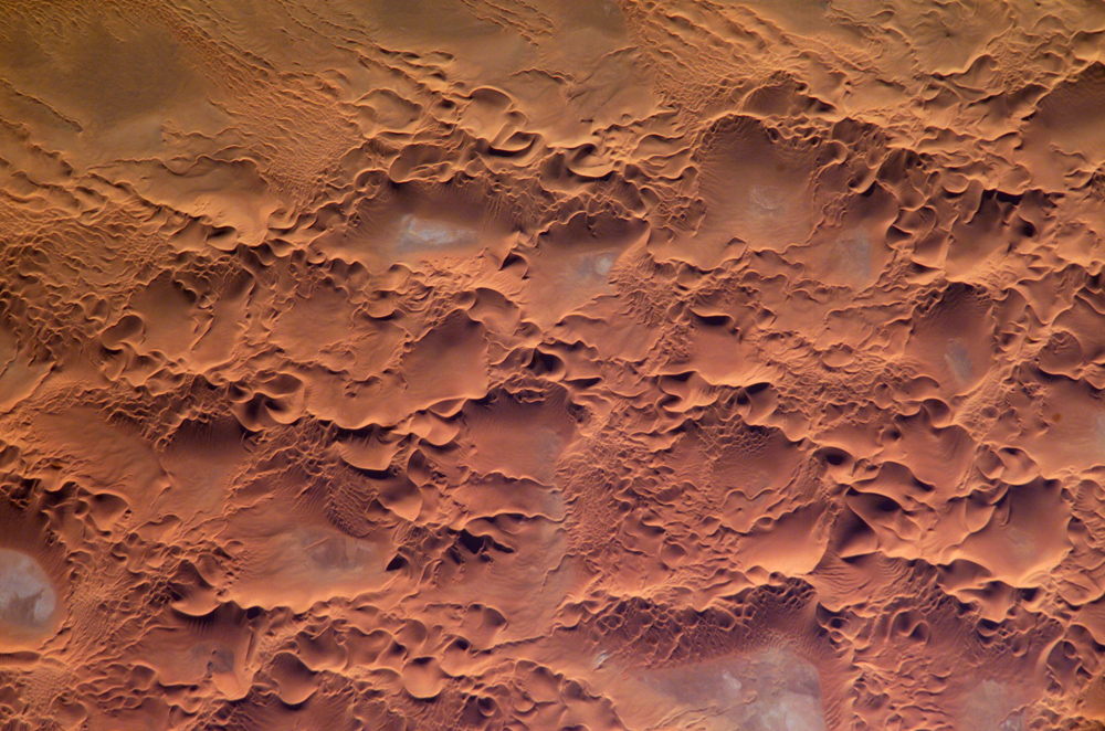
English: Astronaut photo of the Issaouane Erg (Sahara Desert), Algeria.
|
||||||||||||||||||||||||||||||||||||||||||||||||||||||
| Дата | |||||||||||||||||||||||||||||||||||||||||||||||||||||||
| Крыніца | http://earthobservatory.nasa.gov/Newsroom/NewImages/images.php3?img_id=16813 | ||||||||||||||||||||||||||||||||||||||||||||||||||||||
| Аўтар | ISS Crew Earth Observations experiment and the Image Science & Analysis Group, Johnson Space Center. | ||||||||||||||||||||||||||||||||||||||||||||||||||||||
| Дазвол (Паўторнае выкарыстанне гэтага файла) |
NASA, public domain | ||||||||||||||||||||||||||||||||||||||||||||||||||||||
Ліцэнзіяванне
This file is in the public domain in the United States because it was created by the Image Science & Analysis Laboratory, of the NASA Johnson Space Center. NASA copyright policy states that "NASA material is not protected by copyright unless noted". (NASA media use guidelines or Conditions of Use of Astronaut Photographs).
Photo source: ISS010-E-13539.
|
Гісторыя файла
Націснуць на даце з часам, каб паказаць файл, якім ён тады быў.
| Дата і час | Драбніца | Памеры | Удзельнік | Тлумачэнне | |
|---|---|---|---|---|---|
| актуальн. | 20:58, 18 мая 2006 | | 1 000 × 662 (491 KB) | Holly Cheng | ==Summary== {{Information | Description=Astronaut photo of the Issaouane Erg (Sahara Desert), Algeria. | Source=http://earthobservatory.nasa.gov/Newsroom/NewImages/images.php3?img_id=16813 | Date=January 16, 2005 | Author=ISS Crew Earth Observations exper |
Выкарыстанне файла
Наступная 1 старонка выкарыстоўвае гэты файл:
Глабальнае выкарыстанне файла
Гэты файл выкарыстоўваецца ў наступных вікі:
- Выкарыстанне ў ar.wikipedia.org
- Выкарыстанне ў ba.wikipedia.org
- Выкарыстанне ў bg.wikipedia.org
- Выкарыстанне ў br.wikipedia.org
- Выкарыстанне ў ceb.wikipedia.org
- Выкарыстанне ў da.wikipedia.org
- Выкарыстанне ў de.wikipedia.org
- Выкарыстанне ў en.wikipedia.org
- Выкарыстанне ў eo.wikipedia.org
- Выкарыстанне ў fi.wikipedia.org
- Выкарыстанне ў fr.wikipedia.org
- Выкарыстанне ў fr.wiktionary.org
- Выкарыстанне ў hi.wikipedia.org
- Выкарыстанне ў it.wikipedia.org
- Выкарыстанне ў it.wikibooks.org
- Выкарыстанне ў ka.wikipedia.org
- Выкарыстанне ў lt.wikipedia.org
- Выкарыстанне ў mhr.wikipedia.org
- Выкарыстанне ў mk.wikipedia.org
- Выкарыстанне ў nn.wikipedia.org
- Выкарыстанне ў pl.wikipedia.org
- Выкарыстанне ў pl.wiktionary.org
- Выкарыстанне ў ro.wikipedia.org
- Выкарыстанне ў ru.wikipedia.org
- Выкарыстанне ў sl.wikipedia.org
- Выкарыстанне ў sr.wikipedia.org
- Выкарыстанне ў sv.wikipedia.org
- Выкарыстанне ў sv.wiktionary.org
- Выкарыстанне ў uk.wikipedia.org
- Выкарыстанне ў uz.wikipedia.org
- Выкарыстанне ў vi.wikipedia.org
- Выкарыстанне ў www.wikidata.org