
Файл:LA2-Bergslagen-vatten.png

Памер папярэдняга прагляду: 527 × 599 пікселяў. Іншыя разрозненні: 211 × 240 пікселяў | 422 × 480 пікселяў | 938 × 1 066 пікселяў.
Арыгінальны файл (938 × 1 066 кропак, аб’ём файла: 211 KB, тып MIME: image/png)

|
This map image could be re-created using vector graphics as an SVG file. This has several advantages; see Commons:Media for cleanup for more information. If an SVG form of this image is available, please upload it and afterwards replace this template with
{{vector version available|new image name}}.
It is recommended to name the SVG file “LA2-Bergslagen-vatten.svg”—then the template Vector version available (or Vva) does not need the new image name parameter. |
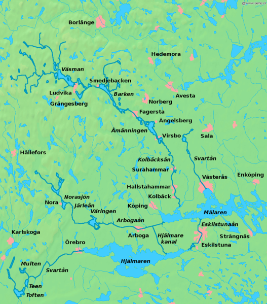
| Апісанне | Map of lakes and rivers in south central Sweden, the Bergslagen region. Bounding box West 14.4°, South 59°, East 17.2°, North 60.6°. Center at 59°48′00″N 15°48′00″E / 59.80000°N 15.80000°E. | ||||
| Дата | |||||
| Крыніца | Background map from the Demis map server, rivers enhanced and names added by user:LA2. | ||||
| Аўтар | Background map from the Demis map server, rivers enhanced and names added by user:LA2. | ||||
| Дазвол (Паўторнае выкарыстанне гэтага файла) |
|
Гісторыя файла
Націснуць на даце з часам, каб паказаць файл, якім ён тады быў.
| Дата і час | Драбніца | Памеры | Удзельнік | Тлумачэнне | |
|---|---|---|---|---|---|
| актуальн. | 00:31, 3 мая 2008 | | 938 × 1 066 (211 KB) | LA2 | {{Information |Description=Map of lakes and rivers in south central Sweden, the Bergslagen region. Bounding box West 14.4°, South 59°, East 17.2°, North 60.6°. Center at {{coor d|59.80000|N|15.80000|E|scale:960000}}. |Source=Background map from th |
Выкарыстанне файла
Наступная 1 старонка выкарыстоўвае гэты файл:
Глабальнае выкарыстанне файла
Гэты файл выкарыстоўваецца ў наступных вікі:
- Выкарыстанне ў cs.wikipedia.org
- Выкарыстанне ў da.wikipedia.org
- Выкарыстанне ў de.wikipedia.org
- Выкарыстанне ў en.wikipedia.org
- Выкарыстанне ў en.wikivoyage.org
- Выкарыстанне ў es.wikipedia.org
- Выкарыстанне ў fi.wikipedia.org
- Выкарыстанне ў fr.wikipedia.org
- Выкарыстанне ў he.wikipedia.org
- Выкарыстанне ў it.wikipedia.org
- Выкарыстанне ў nl.wikipedia.org
- Выкарыстанне ў nn.wikipedia.org
- Выкарыстанне ў no.wikipedia.org
- Выкарыстанне ў pl.wikipedia.org
- Выкарыстанне ў pt.wikipedia.org
- Выкарыстанне ў ru.wikipedia.org
- Выкарыстанне ў sh.wikipedia.org
- Выкарыстанне ў sv.wikipedia.org
Паказаць глабальнае выкарыстанне гэтага файла.