
Файл:Map of Ancient Rome 271 AD.svg

Памер гэтага PNG-прагляду для SVG-файла: 800 × 473 пікселяў. Іншыя разрозненні: 320 × 189 пікселяў | 640 × 379 пікселяў | 1 024 × 606 пікселяў | 1 280 × 757 пікселяў | 2 560 × 1 515 пікселяў | 2 050 × 1 213 пікселяў.
Арыгінальны файл (файл SVG, намінальна 2 050 × 1 213 кропак, аб’ём файла: 207 KB)
Тлумачэнне
| Апісанне |
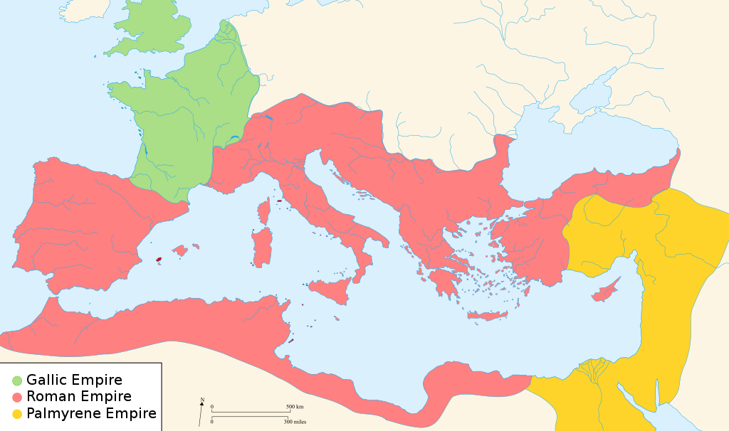
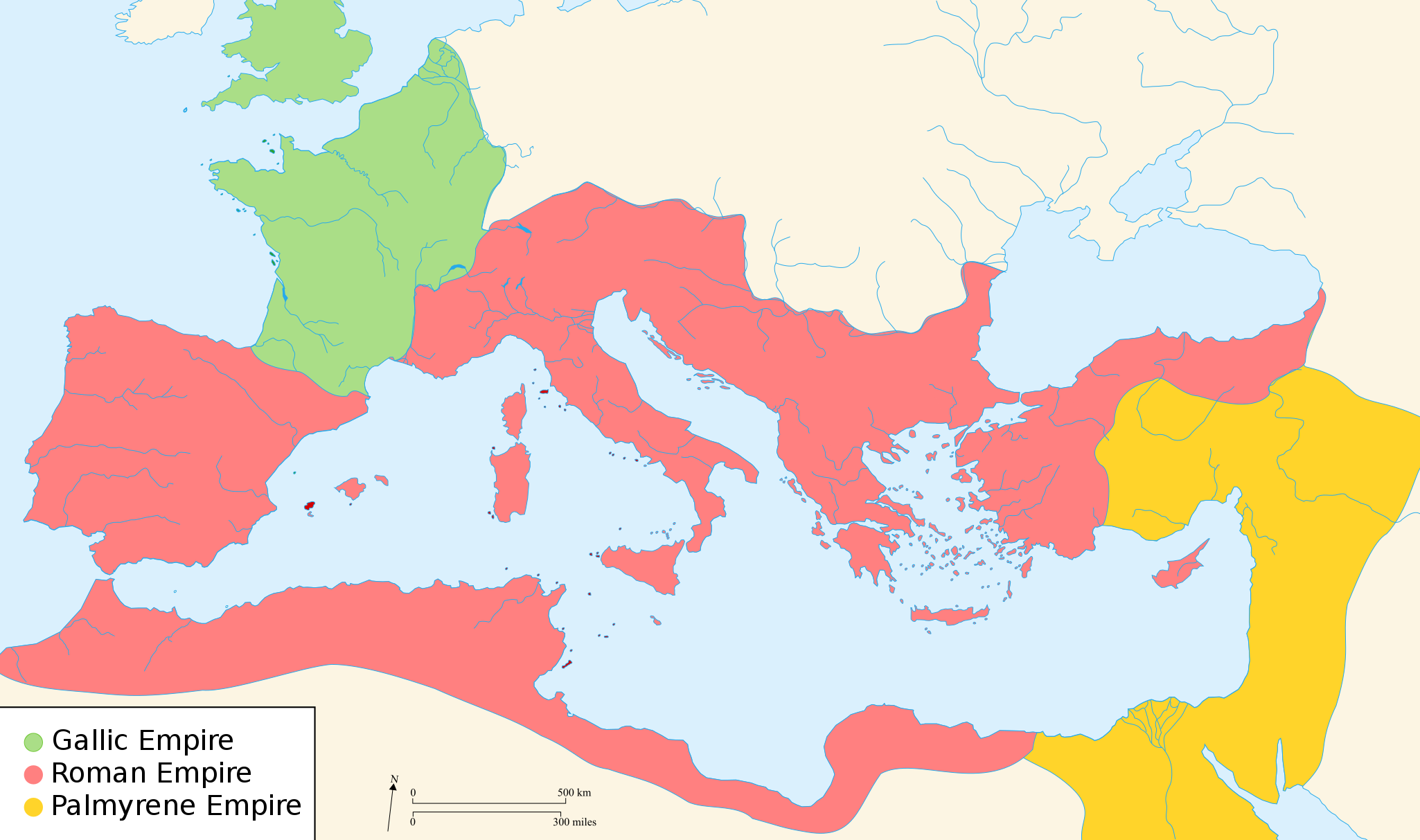
English: Map of the Roman Empire around the year of the consulship of Aurelianus and Bassus (271 AD), with the break away Gallic Empire in the West and the Palmyrene Empire in the East. |
||
| Дата | (UTC) | ||
| Крыніца | |||
| Аўтар |
|
||
| Дазвол (Паўторнае выкарыстанне гэтага файла) |
Я, уладальнік аўтарскіх правоў на гэты твор, добраахвотна публікую яго на ўмовах наступных ліцэнзій:
Гэты файл даступны па ліцэнзіям Creative Commons Пазначэнне аўтарства - На тых самых умовах 2.5 Агульны, 2.0 Агульны і 1.0 Агульны.
Вы можаце выбраць любую з гэтых ліцэнзій. |
||
| Іншыя версіі |
[]
|


.svg)


|
This SVG file contains embedded text that can be translated into your language, using any capable SVG editor, text editor or the SVG Translate tool. For more information see: About translating SVG files. |
Ліцэнзіяванне

|
Дазваляецца капіяваць, распаўсюджваць і(або) мадыфікаваць гэты дакумент на ўмовах ліцэнзіі GNU FDL версіі 1.2 або навейшай, выдадзенай Фондам свабоднага праграмнага забеспячэння; без Нязменных раздзелаў, без тэкстаў Вокладак. Копія ліцэнзіі ёсць у раздзеле GNU Free Documentation License. Subject to disclaimers. |
Журнал арыгінальнай загрузкі
The original description page was here. All following user names refer to en.wikipedia.
- 2007-11-07 02:47 Justinian43 524×377×8 (26490 bytes) The Mediterranean by 271 A.D -The [[Roman Empire]]. -The breakaway [[Gallic Empire]]. -The breakaway [[Palmyrene Empire]].
- derivative work: Pomalee (talk)
other_versions=Derivative works of this file: Map of Ancient Rome 271 AD-sr.svg Permission= GNU Free Documentation License, Version 1.2, Creative Commons Attribution-ShareAlike license versions 3.0, 2.5, 2.0, and 1.0
- Romanworld271AD.jpg: User:Justinian43, uploaded by User:El_bes
| This is a retouched picture, which means that it has been digitally altered from its original version. Modifications: Used "Blank_map_of_South_Europe_and_North_Africa.svg" to refashion "Romanworld271.jpg". The original can be viewed here: Romanworld271AD.jpg:
|

|
Дазваляецца капіяваць, распаўсюджваць і(або) мадыфікаваць гэты дакумент на ўмовах ліцэнзіі GNU FDL версіі 1.2 або навейшай, выдадзенай Фондам свабоднага праграмнага забеспячэння; без Нязменных раздзелаў, без тэкстаў Вокладак. Копія ліцэнзіі ёсць у раздзеле GNU Free Documentation License. |
| Гэты файл даступны па ліцэнзіі Creative Commons Пазначэнне аўтарства - На тых самых умовах 3.0 Непартаваная | ||
| ||
| Гэтая картка дададзеная ў якасці часткі абнаўлення ліцэнзіі GFDL. |
Журнал арыгінальнай загрузкі
This image is a derivative work of the following images:
- File:Blank_map_of_South_Europe_and_North_Africa.svg licensed with Cc-by-sa-2.5,2.0,1.0, GFDL
- 2007-08-09T20:26:49Z Historicair 2050x1213 (1260388 Bytes)
- 2007-08-09T16:12:00Z Historicair 2050x1213 (351130 Bytes) {{Improving}} {{Information |Description={{fr}}Carte vierge de l'Europe du Sud et du Bassin Méditerranée dans l'Antiquité {{en}}Blank map of South Europe and North Africa at Antic period |Source=Own work + [[Image:Blank map of South Europe and North Africa.svg]] by myself
- File:Romanworld271AD.jpg licensed with GFDL-en
- 2007-11-20T15:23:56Z El bes 524x377 (26490 Bytes) {{Information |Description= The Roman Empire around the year 271 AD, with the break awai Gallic Empire in the West |Source= http://en.wikipedia.org/wiki/Image:Romanworld271AD.JPG |Date= November 20th, 2007 |Author= [[http://e
Uploaded with derivativeFX
Гісторыя файла
Націснуць на даце з часам, каб паказаць файл, якім ён тады быў.
| Дата і час | Драбніца | Памеры | Удзельнік | Тлумачэнне | |
|---|---|---|---|---|---|
| актуальн. | 00:07, 21 сакавіка 2022 | | 2 050 × 1 213 (207 KB) | Leptictidium | File uploaded using svgtranslate tool (https://svgtranslate.toolforge.org/). Added translation for ca. |
| 08:06, 24 жніўня 2018 |  | 2 050 × 1 213 (207 KB) | Ras67 | frame removed | |
| 18:14, 18 снежня 2011 |  | 2 050 × 1 213 (385 KB) | Wanwa | more pleasant for eyesight colors | |
| 00:39, 28 жніўня 2010 |  | 2 050 × 1 213 (384 KB) | Cplakidas | Corrections: the Agri Decumates beyond the Rhine had been abandoned already in 263, the Provence and Spain had been recovered by Rome in 269, and in 271, Zenobia controlled Asia Minor as far as Ancara at least | |
| 08:30, 26 лютага 2009 |  | 2 050 × 1 213 (396 KB) | Pomalee | Removed text labels from their paths and created a key. | |
| 07:36, 26 лютага 2009 |  | 2 050 × 1 213 (393 KB) | Pomalee | Changed the "Palmyran" label to "Palmyrene" | |
| 07:15, 26 лютага 2009 |  | 2 050 × 1 213 (393 KB) | Pomalee | {{Information |Description={{en}}Map of the Roman Empire around the year 271 AD, with the break away Gallic Empire in the West and the Palmyric Empire in the East. |Source=*File:Map_of_the_Ancient_Rome_at_Caesar_time-fr.svg *[[:File:Romanworld271AD. |
Выкарыстанне файла
Наступныя 2 старонкі выкарыстоўваюць гэты файл:
Глабальнае выкарыстанне файла
Гэты файл выкарыстоўваецца ў наступных вікі:
- Выкарыстанне ў af.wikipedia.org
- Выкарыстанне ў als.wikipedia.org
- Выкарыстанне ў ar.wikipedia.org
- Выкарыстанне ў azb.wikipedia.org
- Выкарыстанне ў az.wikipedia.org
- Выкарыстанне ў be-tarask.wikipedia.org
- Выкарыстанне ў ca.wikipedia.org
- Выкарыстанне ў cs.wikipedia.org
- Выкарыстанне ў cy.wikipedia.org
- Выкарыстанне ў de.wikipedia.org
- Выкарыстанне ў el.wikipedia.org
- Выкарыстанне ў en.wikipedia.org
- 271
- Aurelian
- Claudius Gothicus
- Crisis of the Third Century
- Outline of ancient Rome
- Western Roman Empire
- Tetricus I
- Ancient Rome
- Late Latin
- Fall of the Western Roman Empire
- List of revolutions and rebellions
- Ledringhem
- List of Roman external wars and battles
- User:ChazCAESAR/sandbox
- User:Kazkaskazkasako/Books/History
- Classical Anatolia
- User:Iazyges/WRE format
- User:Iazyges/Tetricus
Паказаць глабальнае выкарыстанне гэтага файла.