
Файл:Map of Sendai Earthquake 2011.jpg

Арыгінальны файл (897 × 749 кропак, аб’ём файла: 606 KB, тып MIME: image/jpeg)
Тлумачэнне
| Апісанне |
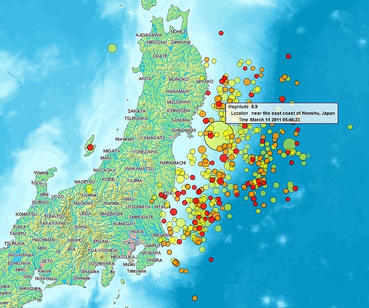
English: Map of the Sendai Earthquake 2011 and aftershocks until March 14, 2011 at 11:20. The size of the circles is a function of magnitude, and the color indicates the date: light green: March 11; yellow: March 12; orange: March 13; red: March 14.
Français : Carte des épicentres et de l'intensité des secousses du tremblement de terre de Sendai du 14 mars 2011. La taille des cercles est fonction de la magnitude, leur couleur indique la date : vert clair, 11.3.2011 ; jaune, 12.3.2011 ; orange, 13.3.2011 ; rouge 14.3.2011.
日本語: 2011年3月11日に発生した東北地方太平洋沖地震、および同14日11時20分までの余震を示した地図。円はマグニチュード、色は発生した日付(黄緑:3月11日、黄:3月12日、橙:3月13日、赤:3月14日)を示す。 |
| Дата | |
| Крыніца | http://www2.demis.nl/quakes/ |
| Аўтар | www2.demis.nl, Uploader User:Heinz-Josef Lücking |
| Дазвол (Паўторнае выкарыстанне гэтага файла) |
Public domain according to http://www2.demis.nl |
|
This work is in the public domain in its country of origin and other countries and areas where the copyright term is the author's life plus 70 years or fewer.
| |
| Гэты файл быў ідэнтыфікаваны як вольны ад вядомых абмежаванняў, згодна з законам аб аўтарскім праве, а таксама ад усіх сумежных правоў. | |
Ліцэнзіяванне
This image is in the public domain because it came from the site https://www.demis.nl/products/web-map-server/examples/ and was released by the copyright holder. Permission is granted to copy, distribute and/or modify this map since it is based on free of copyright images from: www.demis.nl. See also approval email on de.wp and its clarification.
|
| This work has been released into the public domain by its copyright holder, www.demis.nl. This applies worldwide. У некаторых краінах гэта не можа быць юрыдычна магчыма; калі так, то: www.demis.nl дазваляе кожнаму выкарыстоўваць гэты твор ў любых мэтах, без аніякіх умоваў, калі толькі такія ўмовы не патрабуюцца паводле закону.
|
| Гэты файл даступны па ліцэнзіі Creative Commons CC0 1.0 Універсальны Перадача ў грамадскі здабытак | |
| Асоба, якая звязала твор з гэтай дамовай, перадала твор у грамадскі набытак праз адмову ад усіх сваіх правоў па ўсім свеце, згодна з законам аб аўтарскім праве, уключаючы ўсе сумежныя правы ў памеры, у той ступені, якую дазваляе закон. Вы можаце капіраваць, змяняць, распаўсюджваць і выконваць твор, нават для камерцыйных мэтаў, і ўсё без запыту дазволу.
|
Гісторыя файла
Націснуць на даце з часам, каб паказаць файл, якім ён тады быў.
| Дата і час | Драбніца | Памеры | Удзельнік | Тлумачэнне | |
|---|---|---|---|---|---|
| актуальн. | 00:31, 15 сакавіка 2011 | | 897 × 749 (606 KB) | Heinz-Josef Lücking | 14.3 + legend description |
| 07:27, 13 сакавіка 2011 |  | 1 362 × 1 386 (1,41 MB) | Stanqo | 4h05m UTC, 13.03.2011 | |
| 14:10, 12 сакавіка 2011 |  | 1 197 × 1 245 (885 KB) | Yuma | higher resol. | |
| 13:27, 12 сакавіка 2011 |  | 928 × 694 (470 KB) | Yuma | update | |
| 20:20, 11 сакавіка 2011 |  | 1 006 × 773 (596 KB) | Heinz-Josef Lücking | actual 2011-03-11 18:20 | |
| 14:19, 11 сакавіка 2011 |  | 1 014 × 779 (598 KB) | Erdbeben20110311 | actuality | |
| 12:39, 11 сакавіка 2011 |  | 1 009 × 683 (522 KB) | Erdbeben20110311 | {{Information |Description ={{en|1=Map of the Senadai Earthquake 2011}} |Source =http://www2.demis.nl/quakes/ |Author =www2.demis.nl |Date =2011-03-11 |Permission = |other_versions = }} Public domain according to http://ww |
Выкарыстанне файла
Наступная 1 старонка выкарыстоўвае гэты файл:
Глабальнае выкарыстанне файла
Гэты файл выкарыстоўваецца ў наступных вікі:
- Выкарыстанне ў af.wikipedia.org
- Выкарыстанне ў als.wikipedia.org
- Выкарыстанне ў ar.wikipedia.org
- Выкарыстанне ў ast.wikipedia.org
- Выкарыстанне ў az.wikipedia.org
- Выкарыстанне ў bat-smg.wikipedia.org
- Выкарыстанне ў bcl.wikipedia.org
- Выкарыстанне ў be-tarask.wikipedia.org
- Выкарыстанне ў ca.wikipedia.org
- Выкарыстанне ў cu.wikipedia.org
- Выкарыстанне ў da.wikipedia.org
- Выкарыстанне ў de.wikipedia.org
- Выкарыстанне ў el.wikipedia.org
- Выкарыстанне ў en.wikipedia.org
- Выкарыстанне ў en.wikibooks.org
- Выкарыстанне ў eo.wikipedia.org
- Выкарыстанне ў es.wikipedia.org
- Выкарыстанне ў es.wikinews.org
- Выкарыстанне ў eu.wikipedia.org
- Выкарыстанне ў fi.wikipedia.org
- Выкарыстанне ў fr.wikipedia.org
- Выкарыстанне ў ga.wikipedia.org
- Выкарыстанне ў he.wikipedia.org
- Выкарыстанне ў hr.wikipedia.org
- Выкарыстанне ў hu.wikipedia.org
- Выкарыстанне ў id.wikipedia.org
- Выкарыстанне ў is.wikipedia.org
- Выкарыстанне ў it.wikinews.org
- Выкарыстанне ў ja.wikipedia.org
- Выкарыстанне ў ko.wikipedia.org
- Выкарыстанне ў ksh.wikipedia.org
- Выкарыстанне ў lt.wikipedia.org
- Выкарыстанне ў mrj.wikipedia.org
- Выкарыстанне ў ms.wikipedia.org
- Выкарыстанне ў nl.wikipedia.org
- Выкарыстанне ў nn.wikipedia.org
- Выкарыстанне ў no.wikipedia.org
Паказаць глабальнае выкарыстанне гэтага файла.