
Файл:Map of Sunda and Sahul.png
Памер папярэдняга прагляду: 661 × 599 пікселяў. Іншыя разрозненні: 265 × 240 пікселяў | 530 × 480 пікселяў | 847 × 768 пікселяў | 1 111 × 1 007 пікселяў.
Арыгінальны файл (1 111 × 1 007 кропак, аб’ём файла: 208 KB, тып MIME: image/png)

|
File:Map of Sunda and Sahul.svg is a vector version of this file. It should be used in place of this PNG file when not inferior.
File:Map of Sunda and Sahul.png → File:Map of Sunda and Sahul.svg
For more information, see Help:SVG. |
 |
| Апісанне |
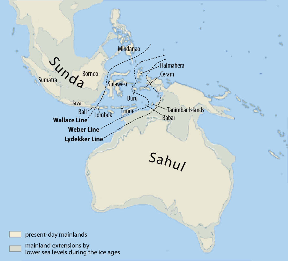
Deutsch: Karte von Sunda und Sahul sowie der Wallace-Linie, der Lydekker-Linie und der Weber-Linie.
Français : Carte de Sunda, de Sahul et de la ligne Wallace, de la ligne Lydekker et de la ligne Weber
Español: Mapa de Sunda y Sahul con la línea de Wallace, la línea de Lydekker y la línea de Weber.
|
| Дата | |
| Крыніца | Self made, using this map for the background |
| Аўтар | Maximilian Dörrbecker (Chumwa) |
| Дазвол (Паўторнае выкарыстанне гэтага файла) |
Я, уладальнік аўтарскіх правоў на гэты твор, добраахвотна публікую яго на ўмовах наступнай ліцэнзіі: Гэты файл даступны па ліцэнзіі Creative Commons Пазначэнне аўтарства - На тых самых умовах 3.0 Непартаваная
Sie dürfen das Bild zu den folgenden Bedingungen nutzen:
|
| Іншыя версіі |
|


Гісторыя файла
Націснуць на даце з часам, каб паказаць файл, якім ён тады быў.
| Дата і час | Драбніца | Памеры | Удзельнік | Тлумачэнне | |
|---|---|---|---|---|---|
| актуальн. | 11:07, 5 сакавіка 2017 | | 1 111 × 1 007 (208 KB) | Chumwa | corr |
| 09:46, 25 ліпеня 2009 |  | 1 111 × 1 007 (269 KB) | Chumwa | Inseln -> Islands | |
| 09:13, 25 ліпеня 2009 |  | 1 111 × 1 007 (268 KB) | Chumwa | {{Information |Description= {{ de }}Karte von Sunda und Sahul sowie der Wallace-Linie, der Lydekker-Linie und der Weber-Linie. * Als Sahul wird die zusammenhängende Landmasse bezeichnet, die während der letzten Eiszeit aus Australien, der nordöstlich d |
Выкарыстанне файла
Наступная 1 старонка выкарыстоўвае гэты файл:
Глабальнае выкарыстанне файла
Гэты файл выкарыстоўваецца ў наступных вікі:
- Выкарыстанне ў ar.wikipedia.org
- Выкарыстанне ў ast.wikipedia.org
- Выкарыстанне ў bg.wikipedia.org
- Выкарыстанне ў bn.wikipedia.org
- Выкарыстанне ў ca.wikipedia.org
- Выкарыстанне ў cs.wikipedia.org
- Выкарыстанне ў de.wikipedia.org
- Выкарыстанне ў en.wikipedia.org
- Dingo
- New Guinea singing dog
- List of lost lands
- Red-naped trogon
- Models of migration to the Philippines
- Denisovan
- Canis lupus dingo
- User:Cruickshanks/Sandbox
- User:Obsidian Soul/sandbox
- Wikipedia:Reference desk/Archives/Science/2011 May 15
- List of butterflies of the Philippines
- Wikipedia:Categories for discussion/Log/2015 June 26
- Выкарыстанне ў eo.wikipedia.org
- Выкарыстанне ў es.wikipedia.org
- Выкарыстанне ў fa.wikipedia.org
- Выкарыстанне ў fi.wikipedia.org
- Выкарыстанне ў fr.wikipedia.org
- Выкарыстанне ў gl.wikipedia.org
Паказаць глабальнае выкарыстанне гэтага файла.