
Файл:Map of Florida by John de Solís (1764).jpg

Памер папярэдняга прагляду: 460 × 599 пікселяў. Іншыя разрозненні: 184 × 240 пікселяў | 368 × 480 пікселяў | 589 × 768 пікселяў | 786 × 1 024 пікселяў | 2 075 × 2 704 пікселяў.
Арыгінальны файл (2 075 × 2 704 кропак, аб’ём файла: 634 KB, тып MIME: image/jpeg)
.jpg)
Тлумачэнне
| Апісанне |
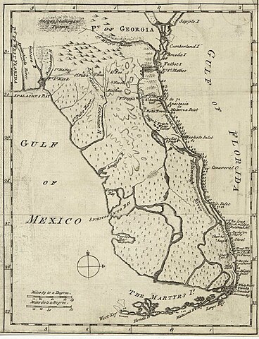
English: Map of Florida of ca. 1764]].
|
| Дата | circa 1764 |
| Крыніца | US Library of Congress |
| Аўтар | "Don John de Solís, surveyor, who resided there near twenty years" |
Ліцэнзіяванне
|
This work is in the public domain in its country of origin and other countries and areas where the copyright term is the author's life plus 100 years or fewer. | |
| Гэты файл быў ідэнтыфікаваны як вольны ад вядомых абмежаванняў, згодна з законам аб аўтарскім праве, а таксама ад усіх сумежных правоў. | |
Гісторыя файла
Націснуць на даце з часам, каб паказаць файл, якім ён тады быў.
| Дата і час | Драбніца | Памеры | Удзельнік | Тлумачэнне | |
|---|---|---|---|---|---|
| актуальн. | 02:06, 28 мая 2018 | | 2 075 × 2 704 (634 KB) | Hispalois | Higher-resolution image. Please note that this map has no relationship whatsoever with 16th-century explorer Juan Díaz de Solís. |
| 20:16, 15 чэрвеня 2006 |  | 399 × 500 (49 KB) | Eamezaga | Map published in the US depicting a very accurate shape of Florida (1764), based on an ancient draft drawn by the Spanish-Portuguese explorer and discoverer Juan Díaz de Solís (US Library of Congress, released to public domain) |
Выкарыстанне файла
Няма старонак, якія выкарыстоўваюць гэты файл.
Глабальнае выкарыстанне файла
Гэты файл выкарыстоўваецца ў наступных вікі:
- Выкарыстанне ў en.wikipedia.org
- Выкарыстанне ў it.wikipedia.org
.jpg)