
Файл:Mediterranean Relief.jpg
Памер папярэдняга прагляду: 800 × 448 пікселяў. Іншыя разрозненні: 320 × 179 пікселяў | 640 × 359 пікселяў | 1 308 × 733 пікселяў.
Арыгінальны файл (1 308 × 733 кропак, аб’ём файла: 635 KB, тып MIME: image/jpeg)

|
This map image could be re-created using vector graphics as an SVG file. This has several advantages; see Commons:Media for cleanup for more information. If an SVG form of this image is available, please upload it and afterwards replace this template with
{{vector version available|new image name}}.
It is recommended to name the SVG file “Mediterranean Relief.svg”—then the template Vector version available (or Vva) does not need the new image name parameter. |


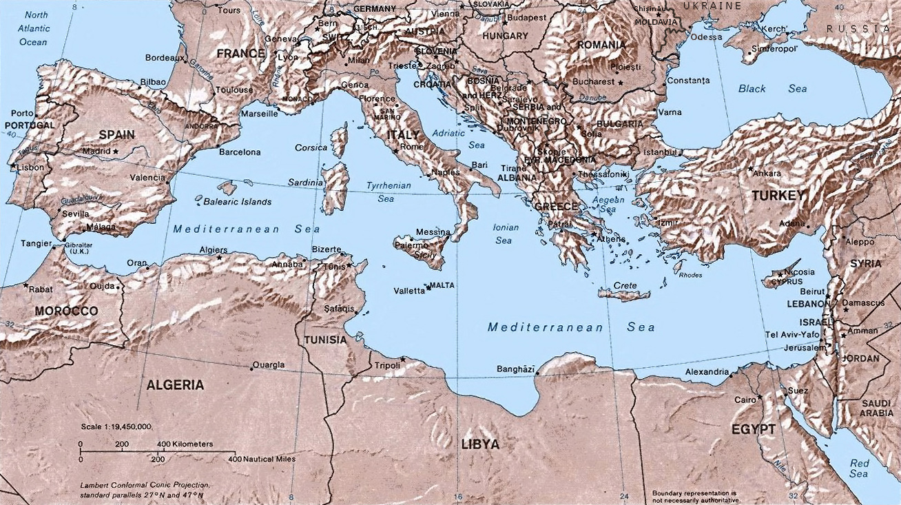
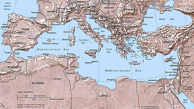
- Shaded relief Map of the Mediterranean Sea - and its Basin and Landforms.
- The original map was created in 1982 by the Central Intelligence Agency ([1], specifically [2]).
- This version was produced by w:User:Joy, who originally uploaded it to the English Wikipedia:
- 23:46, 28 Sep 2004 . . Joy (343433 bytes) (an update after 22 years :) added borders and names for the ex-yu republics (si,hr,ba,cs,mk); corrected names for de,sk; dropped su name but didn't bother drawing the md/uk/ru borders or names because they're not near the topic at hand, and it's tiresome)
![[2]](http://www.lib.utexas.edu/maps/europe/mediterranean_rel82.jpg)
This work is in the public domain in the United States because it is a work prepared by an officer or employee of the United States Government as part of that person’s official duties under the terms of Title 17, Chapter 1, Section 105 of the US Code.
Note: This only applies to original works of the Federal Government and not to the work of any individual U.S. state, territory, commonwealth, county, municipality, or any other subdivision. This template also does not apply to postage stamp designs published by the United States Postal Service since 1978. (See § 313.6(C)(1) of Compendium of U.S. Copyright Office Practices). It also does not apply to certain US coins; see The US Mint Terms of Use.
|
 | |
| Гэты файл быў ідэнтыфікаваны як вольны ад вядомых абмежаванняў, згодна з законам аб аўтарскім праве, а таксама ад усіх сумежных правоў. | ||
Гісторыя файла
Націснуць на даце з часам, каб паказаць файл, якім ён тады быў.
| Дата і час | Драбніца | Памеры | Удзельнік | Тлумачэнне | |
|---|---|---|---|---|---|
| актуальн. | 17:32, 6 мая 2016 | | 1 308 × 733 (635 KB) | Julieta39 | Actualised the borders |
| 00:38, 31 мая 2015 |  | 1 308 × 733 (614 KB) | Subtropical-man | Reverted to version as of 18:25, 29 August 2011 | |
| 03:59, 1 верасня 2011 |  | 1 428 × 800 (400 KB) | Gwillhickers | Larger image, better sharpness | |
| 03:58, 1 верасня 2011 |  | 1 428 × 800 (400 KB) | Gwillhickers | Larger ima | |
| 21:25, 29 жніўня 2011 |  | 1 308 × 733 (614 KB) | Subtropical-man | ||
| 01:21, 25 жніўня 2011 |  | 1 428 × 800 (400 KB) | Gwillhickers | better sharpness, color tone | |
| 04:01, 27 чэрвеня 2010 |  | 1 308 × 733 (614 KB) | Ras67 | rotated and cropped | |
| 23:22, 4 чэрвеня 2010 |  | 1 325 × 739 (288 KB) | Cropbot | upload cropped version, operated by User:diaa_abdelmoneim. Summary: cropped | |
| 22:22, 21 снежня 2005 |  | 1 332 × 792 (274 KB) | Lhgodoy~commonswiki | Noise removal in original image | |
| 23:59, 4 снежня 2004 |  | 1 332 × 792 (335 KB) | Alfio | Map of the Mediterranean Sea |
Выкарыстанне файла
Наступная 1 старонка выкарыстоўвае гэты файл:
Глабальнае выкарыстанне файла
Гэты файл выкарыстоўваецца ў наступных вікі:
- Выкарыстанне ў af.wikipedia.org
- Выкарыстанне ў am.wikipedia.org
- Выкарыстанне ў arc.wikipedia.org
- Выкарыстанне ў ar.wikipedia.org
- Выкарыстанне ў arz.wikipedia.org
- Выкарыстанне ў ast.wikipedia.org
- Выкарыстанне ў as.wikipedia.org
- Выкарыстанне ў az.wikipedia.org
- Выкарыстанне ў az.wiktionary.org
- Выкарыстанне ў bo.wikipedia.org
- Выкарыстанне ў bs.wikipedia.org
- Выкарыстанне ў ca.wikipedia.org
- Выкарыстанне ў ceb.wikipedia.org
- Выкарыстанне ў cv.wikipedia.org
- Выкарыстанне ў cy.wikipedia.org
- Выкарыстанне ў da.wikipedia.org
- Выкарыстанне ў de.wikipedia.org
- Выкарыстанне ў dsb.wikipedia.org
- Выкарыстанне ў dty.wikipedia.org
- Выкарыстанне ў el.wikipedia.org
- Выкарыстанне ў en.wikipedia.org
- Выкарыстанне ў en.wiktionary.org
- Выкарыстанне ў eo.wikipedia.org
- Выкарыстанне ў es.wikipedia.org
- Выкарыстанне ў es.wikibooks.org
Паказаць глабальнае выкарыстанне гэтага файла.