
Файл:Panampangan Island.jpg

Памер папярэдняга прагляду: 799 × 599 пікселяў. Іншыя разрозненні: 320 × 240 пікселяў | 640 × 480 пікселяў | 1 024 × 768 пікселяў | 1 280 × 960 пікселяў | 2 560 × 1 920 пікселяў | 3 973 × 2 980 пікселяў.
Арыгінальны файл (3 973 × 2 980 кропак, аб’ём файла: 1,33 MB, тып MIME: image/jpeg)
Тлумачэнне
| Апісанне |
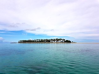
English: Panampangan island is located at the Basibuli Reef and possesses longest sandbar in the Philippines at the province of Tawi-Tawi. This was taken using the joint mapping, reconnaissance, and deployment mission of the Philippine Marine Corps and Schadow1 Expeditions |
||
| Дата | |||
| Крыніца | Уласная праца | ||
| Аўтар | Ervin Malicdem | ||
| Дазвол (Паўторнае выкарыстанне гэтага файла) |
Гэты файл даступны па ліцэнзіі Creative Commons Пазначэнне аўтарства - На тых самых умовах 3.0 Міжнародны
|

| Camera location | | View this and other nearby images on: OpenStreetMap |
|---|
Initially published at Schadow1 Expeditions article available at http://www.s1expeditions.com/2017/06/217-panampangan-islandtawi-tawi.html
Гісторыя файла
Націснуць на даце з часам, каб паказаць файл, якім ён тады быў.
| Дата і час | Драбніца | Памеры | Удзельнік | Тлумачэнне | |
|---|---|---|---|---|---|
| актуальн. | 10:11, 15 верасня 2017 | | 3 973 × 2 980 (1,33 MB) | Schadow1 | User created page with UploadWizard |
Выкарыстанне файла
Наступная 1 старонка выкарыстоўвае гэты файл:
Глабальнае выкарыстанне файла
Гэты файл выкарыстоўваецца ў наступных вікі:
- Выкарыстанне ў bjn.wikipedia.org
- Выкарыстанне ў bn.wikipedia.org
- Выкарыстанне ў ceb.wikipedia.org
- Выкарыстанне ў en.wikipedia.org
- Выкарыстанне ў fa.wikipedia.org
- Выкарыстанне ў hr.wikipedia.org
- Выкарыстанне ў id.wikipedia.org
- Выкарыстанне ў ilo.wikipedia.org
- Выкарыстанне ў mk.wikipedia.org
- Выкарыстанне ў ms.wikipedia.org
- Выкарыстанне ў simple.wikipedia.org
- Выкарыстанне ў th.wikipedia.org
- Выкарыстанне ў tl.wikipedia.org
- Выкарыстанне ў vi.wikipedia.org
- Выкарыстанне ў www.wikidata.org
- Выкарыстанне ў zh.wikipedia.org