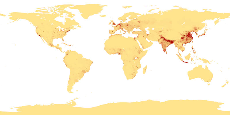
Файл:Population density.png

Памер папярэдняга прагляду: 800 × 400 пікселяў. Іншыя разрозненні: 320 × 160 пікселяў | 640 × 320 пікселяў | 1 024 × 512 пікселяў | 1 280 × 640 пікселяў | 2 560 × 1 280 пікселяў | 4 320 × 2 160 пікселяў.
Арыгінальны файл (4 320 × 2 160 кропак, аб’ём файла: 522 KB, тып MIME: image/png)
Гісторыя файла
Націснуць на даце з часам, каб паказаць файл, якім ён тады быў.
| Дата і час | Драбніца | Памеры | Удзельнік | Тлумачэнне | |
|---|---|---|---|---|---|
| актуальн. | 03:41, 11 красавіка 2013 |  | 4 320 × 2 160 (522 KB) | Jahoe | Re-downloaded original from http://eoimages.gsfc.nasa.gov/images/imagerecords/53000/53005/population_density.tif, re-converted to PNG (preserving alpha channel) using tiff2png (by Willem van Schaik and Greg Roelofs). Removed rgb pixel values from fully... |
| 06:41, 27 лютага 2007 |  | 4 320 × 2 160 (915 KB) | Keenan Pepper | This image shows the number of people per square kilometer around the world in 1994. The data were derived from population records based on political divisions such as states, provinces, and counties. The image was taken from [http://visibleearth.nasa.go |
Выкарыстанне файла
Наступная 1 старонка выкарыстоўвае гэты файл:
Глабальнае выкарыстанне файла
Гэты файл выкарыстоўваецца ў наступных вікі:
- Выкарыстанне ў als.wikipedia.org
- Выкарыстанне ў an.wikipedia.org
- Выкарыстанне ў ar.wikipedia.org
- Выкарыстанне ў ast.wikipedia.org
- Выкарыстанне ў az.wikipedia.org
- Выкарыстанне ў be-tarask.wikipedia.org
- Выкарыстанне ў bg.wikipedia.org
- Выкарыстанне ў bh.wikipedia.org
- Выкарыстанне ў bn.wikipedia.org
- Выкарыстанне ў bs.wikipedia.org
- Выкарыстанне ў ca.wikipedia.org
- Выкарыстанне ў ce.wikipedia.org
- Выкарыстанне ў ckb.wikipedia.org
- Выкарыстанне ў cu.wikipedia.org
- Выкарыстанне ў cv.wikipedia.org
- Выкарыстанне ў da.wikipedia.org
- Выкарыстанне ў da.wikibooks.org
- Выкарыстанне ў de.wikipedia.org
- Выкарыстанне ў dsb.wikipedia.org
- Выкарыстанне ў el.wikipedia.org
- Выкарыстанне ў en.wikipedia.org
- Выкарыстанне ў en.wikiquote.org
- Выкарыстанне ў eo.wikipedia.org
- Выкарыстанне ў es.wikipedia.org
Паказаць глабальнае выкарыстанне гэтага файла.


