
Файл:Rangifer tarandus map.png

Памер папярэдняга прагляду: 800 × 397 пікселяў. Іншыя разрозненні: 320 × 159 пікселяў | 640 × 318 пікселяў | 1 024 × 508 пікселяў | 1 600 × 794 пікселяў.
Арыгінальны файл (1 600 × 794 кропак, аб’ём файла: 107 KB, тып MIME: image/png)
Тлумачэнне
| Апісанне |
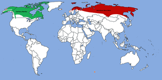
Map: Distribution of Rangifer tarandus (Caribou/Reindeer)
|
| Дата | |
| Крыніца | Уласная праца |
| Аўтар | TBjornstad 11:46, 31 October 2006 (UTC) |
| Дазвол (Паўторнае выкарыстанне гэтага файла) |
Public Domain |

|
This biogeographical map image could be re-created using vector graphics as an SVG file. This has several advantages; see Commons:Media for cleanup for more information. If an SVG form of this image is available, please upload it and afterwards replace this template with
{{vector version available|new image name}}.
It is recommended to name the SVG file “Rangifer tarandus map.svg”—then the template Vector version available (or Vva) does not need the new image name parameter. |
Ліцэнзіяванне
| Я, уладальнік аўтарскіх правоў на гэты твор, перадаю яго ў грамадскі набытак. Дазвол сапраўдны для ўсяго свету. У некаторых краінах гэта не можа быць юрыдычна магчыма; калі так, то: Я дазваляю кожнаму выкарыстоўваць гэтую працу ў любых мэтах, без аніякіх умоваў, калі толькі такія ўмовы не патрабуюцца паводле закону. |
Гісторыя файла
Націснуць на даце з часам, каб паказаць файл, якім ён тады быў.
| Дата і час | Драбніца | Памеры | Удзельнік | Тлумачэнне | |
|---|---|---|---|---|---|
| актуальн. | 16:39, 20 снежня 2019 | | 1 600 × 794 (107 KB) | Fenn-O-maniC | Fixed the southern border in Fennoscandia as according to https://www.suomenpeura.fi/en/wild-forest-reindeer/range.html (for forest reindeer, R. t. fennicus) and https://www.nordregio.org/maps/reindeer-herding-area/ (for mountain reindeer, R. t. tarandus, and its semi-domestic form) |
| 01:57, 9 ліпеня 2019 |  | 1 600 × 794 (106 KB) | Howpper | That part in southern Greenland should be green, because it was part of the larger green area, before I reduced it. | |
| 20:37, 8 мая 2019 |  | 1 600 × 794 (126 KB) | Fährtenleser | Europäische Rentiere in Alaska (http://reindeerherding.org/herders/inupiaq-eskimo/) und Grönland (http://reindeerherding.org/herders/greenland/) hinzugefügt; Süd-Georgien wieder entfernt (lt. Artikel) | |
| 00:50, 18 жніўня 2018 |  | 1 600 × 794 (63 KB) | Howpper | North America fixes. | |
| 23:07, 2 кастрычніка 2014 |  | 1 600 × 794 (105 KB) | Fährtenleser | Svalbard and the other siberian islands added and scandinavien population corrected | |
| 18:30, 10 жніўня 2012 |  | 1 600 × 794 (96 KB) | MPF | Range shown in Eurasia was too extensive; change introduced populations to orange | |
| 23:27, 23 студзеня 2012 |  | 1 600 × 794 (95 KB) | Lemonade100 | Added population in east Iceland and the Highlands of Scotland, Great Britain | |
| 15:38, 15 сакавіка 2009 |  | 1 600 × 794 (47 KB) | Bogomolov.PL | added South Georgia | |
| 15:21, 15 сакавіка 2009 |  | 1 600 × 794 (47 KB) | Bogomolov.PL | Added en:Tuva and NW en:Mongolia | |
| 19:32, 17 снежня 2008 |  | 1 600 × 794 (216 KB) | Nesnad | ^o^ oops i was missing somethig apparently small population on an island here |
Выкарыстанне файла
Наступная 1 старонка выкарыстоўвае гэты файл:
Глабальнае выкарыстанне файла
Гэты файл выкарыстоўваецца ў наступных вікі:
- Выкарыстанне ў af.wikipedia.org
- Выкарыстанне ў alt.wikipedia.org
- Выкарыстанне ў am.wikipedia.org
- Выкарыстанне ў ang.wikipedia.org
- Выкарыстанне ў ar.wikipedia.org
- Выкарыстанне ў arz.wikipedia.org
- Выкарыстанне ў ast.wikipedia.org
- Выкарыстанне ў avk.wikipedia.org
- Выкарыстанне ў be-tarask.wikipedia.org
- Выкарыстанне ў bg.wikipedia.org
- Выкарыстанне ў bjn.wikipedia.org
- Выкарыстанне ў bn.wikipedia.org
- Выкарыстанне ў ca.wikipedia.org
- Выкарыстанне ў ceb.wikipedia.org
- Выкарыстанне ў cr.wikipedia.org
- Выкарыстанне ў cs.wikipedia.org
- Выкарыстанне ў cy.wikipedia.org
- Выкарыстанне ў da.wikipedia.org
- Выкарыстанне ў de.wikipedia.org
- Выкарыстанне ў el.wikipedia.org
- Выкарыстанне ў en.wikipedia.org
- Выкарыстанне ў eo.wikipedia.org
- Выкарыстанне ў es.wikipedia.org
- Выкарыстанне ў eu.wikipedia.org
- Выкарыстанне ў fa.wikipedia.org
- Выкарыстанне ў fi.wikipedia.org
- Выкарыстанне ў fr.wikipedia.org
- Выкарыстанне ў ga.wikipedia.org
- Выкарыстанне ў gl.wikipedia.org
- Выкарыстанне ў hi.wikipedia.org
- Выкарыстанне ў hr.wikipedia.org
- Выкарыстанне ў hu.wikipedia.org
- Выкарыстанне ў id.wikipedia.org
- Выкарыстанне ў is.wikipedia.org
- Выкарыстанне ў ja.wikipedia.org
- Выкарыстанне ў kab.wikipedia.org
- Выкарыстанне ў ka.wikipedia.org
- Выкарыстанне ў kk.wikipedia.org
- Выкарыстанне ў kl.wikipedia.org
- Выкарыстанне ў ko.wikipedia.org
- Выкарыстанне ў ku.wikipedia.org
- Выкарыстанне ў lt.wikipedia.org
- Выкарыстанне ў lv.wikipedia.org
- Выкарыстанне ў ml.wikipedia.org
Паказаць глабальнае выкарыстанне гэтага файла.