
Файл:Roman Italy.gif

Памер папярэдняга прагляду: 519 × 600 пікселяў. Іншыя разрозненні: 208 × 240 пікселяў | 415 × 480 пікселяў | 846 × 978 пікселяў.
Арыгінальны файл (846 × 978 кропак, аб’ём файла: 72 KB, тып MIME: image/gif)
Тлумачэнне

|
This locator map image could be re-created using vector graphics as an SVG file. This has several advantages; see Commons:Media for cleanup for more information. If an SVG form of this image is available, please upload it and afterwards replace this template with
{{vector version available|new image name}}.
It is recommended to name the SVG file “Roman Italy.svg”—then the template Vector version available (or Vva) does not need the new image name parameter. |

| Апісанне |
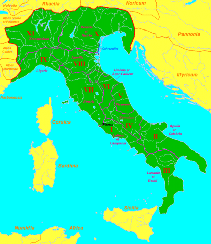
English: Map of Roman Italy (green) and surrounding provinces (orange), showing its division in 11 regiones, with their names.
Sources: partly based in maps of the University of Oregon [1], [2] and several maps and data of Wikipedia. |
| Дата | 16 лістапада 2007 (original upload date) |
| Крыніца | Transferred from en.wikipedia to Commons. |
| Аўтар | Sugaar at англійская Вікіпедыя |
![[1]](http://darkwing.uoregon.edu/~mapplace/EU/EU02-RepItaly/EU02-26.gif)
![[2]](http://darkwing.uoregon.edu/~mapplace/EU/EU02-RepItaly/EU02-25.jpeg)
Ліцэнзіяванне
| Гэты твор быў перададзены ў грамадскі набытак яго аутарам, Sugaar at англійская Вікіпедыя. Дазвол сапраўдны для ўсяго свету. У некаторых краінах гэта не можа быць юрыдычна магчыма; калі так, то: Sugaar дазваляе кожнаму выкарыстоўваць гэты твор ў любых мэтах, без аніякіх умоваў, калі толькі такія ўмовы не патрабуюцца паводле закону. |
Журнал арыгінальнай загрузкі
The original description page was here. All following user names refer to en.wikipedia.
- 2007-11-16 07:29 Sugaar 846×978×8 (43924 bytes) Map of [[Italia (Roman Empire)|Roman Italy]] (green) and surrounding provinces (orange), showing its division in 11 ''regiones'', with their names.
Гісторыя файла
Націснуць на даце з часам, каб паказаць файл, якім ён тады быў.
| Дата і час | Драбніца | Памеры | Удзельнік | Тлумачэнне | |
|---|---|---|---|---|---|
| актуальн. | 23:10, 27 жніўня 2013 | | 846 × 978 (72 KB) | Enok | fixed border of Etruria |
| 19:47, 20 лютага 2008 |  | 846 × 978 (43 KB) | Mach | {{Information |Description={{en|Map of Roman Italy (green) and surrounding provinces (orange), showing its division in 11 ''regiones'', with their names. Sources: partly based in maps of the University of Oregon [http://dark |
Выкарыстанне файла
Наступная 1 старонка выкарыстоўвае гэты файл:
Глабальнае выкарыстанне файла
Гэты файл выкарыстоўваецца ў наступных вікі:
- Выкарыстанне ў ar.wikipedia.org
- Выкарыстанне ў bg.wikipedia.org
- Выкарыстанне ў de.wikipedia.org
- Выкарыстанне ў el.wikipedia.org
- Выкарыстанне ў en.wikipedia.org
- Выкарыстанне ў es.wikipedia.org
- Выкарыстанне ў et.wikipedia.org
- Выкарыстанне ў fa.wikipedia.org
- Выкарыстанне ў gl.wikipedia.org
- Выкарыстанне ў hr.wikipedia.org
- Выкарыстанне ў hu.wikipedia.org
- Выкарыстанне ў hy.wikipedia.org
- Выкарыстанне ў id.wikipedia.org
- Выкарыстанне ў it.wikipedia.org
- Выкарыстанне ў ja.wikipedia.org
- Выкарыстанне ў ka.wikipedia.org
- Выкарыстанне ў ko.wikipedia.org
- Выкарыстанне ў lt.wikipedia.org
- Выкарыстанне ў mr.wikipedia.org
- Выкарыстанне ў ms.wikipedia.org
- Выкарыстанне ў nl.wikipedia.org
- Выкарыстанне ў no.wikipedia.org
- Выкарыстанне ў oc.wikipedia.org
- Выкарыстанне ў pl.wiktionary.org
- Выкарыстанне ў pt.wikipedia.org
- Выкарыстанне ў ro.wikipedia.org
- Выкарыстанне ў ru.wikipedia.org
- Выкарыстанне ў sh.wikipedia.org
- Выкарыстанне ў simple.wikipedia.org
- Выкарыстанне ў sl.wikipedia.org
Паказаць глабальнае выкарыстанне гэтага файла.