
Файл:Sahel Map-Africa rough.png
Памер папярэдняга прагляду: 800 × 370 пікселяў. Іншыя разрозненні: 320 × 148 пікселяў | 640 × 296 пікселяў | 1 024 × 474 пікселяў | 2 000 × 925 пікселяў.
Арыгінальны файл (2 000 × 925 кропак, аб’ём файла: 291 KB, тып MIME: image/png)

|
This file requires updating because: south soudan In doing so, you could add a timestamp to the file.
|
| Апісанне |
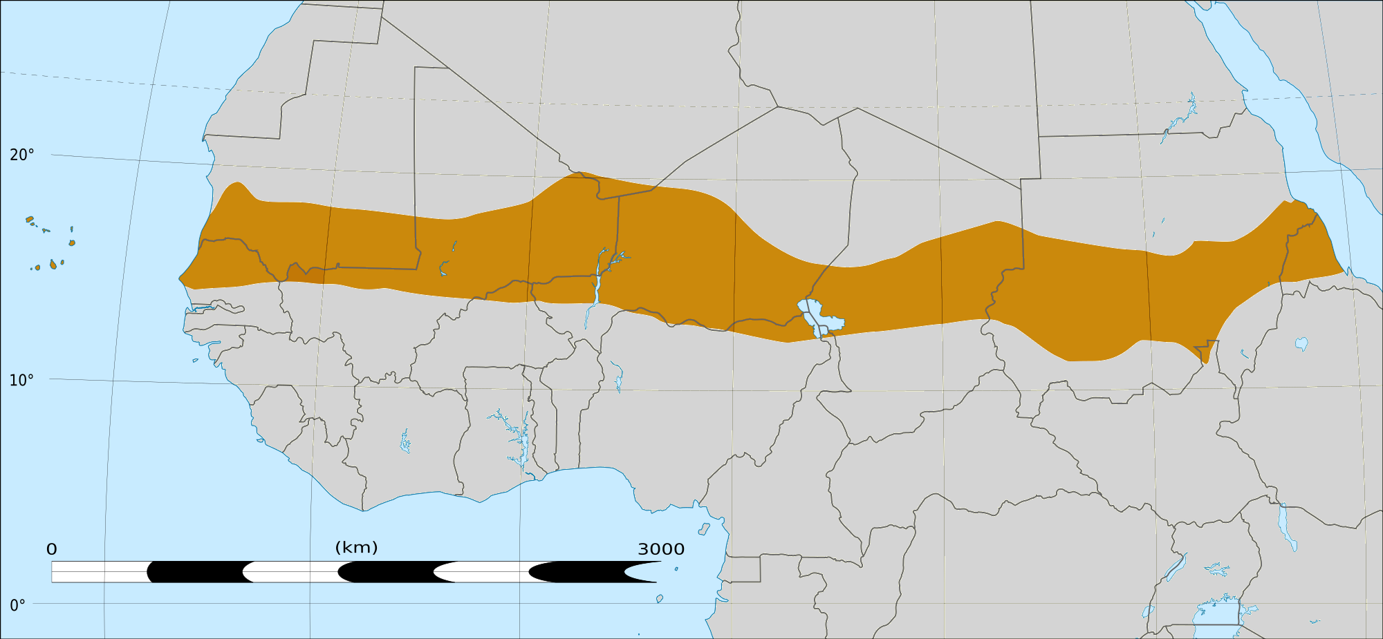
English: Map of Africa, with the Sahel highlighted in orange.
This is roughly the African land area between the lines of 200mm (north) and 600mm (south) mean 20th century annual rainfall. This is limited to land areas directly to the south of the Sahara desert and including the islands of Cape Verde, but not including other areas in Africa with the same rainfall statistics. This is one, but not the only, definition of the Sahel region. |
|||
| Дата | 20 лютага 2009 03:54 (UTC) | |||
| Крыніца |
Felix Koenig: "created/photographed by myself (based on the existing blank map of Africa)"
|
|||
| Аўтар | ||||
| Іншыя версіі |
|


| This is a retouched picture, which means that it has been digitally altered from its original version. Modifications: Reproduced Sahel boundary from Map sahel.jpg on png map, cropped. The original can be viewed here: BlankMap-Africa2.png:
|
Ліцэнзіяванне
Я, уладальнік аўтарскіх правоў на гэты твор, добраахвотна публікую яго на ўмовах наступных ліцэнзій:

|
Дазваляецца капіяваць, распаўсюджваць і(або) мадыфікаваць гэты дакумент на ўмовах ліцэнзіі GNU FDL версіі 1.2 або навейшай, выдадзенай Фондам свабоднага праграмнага забеспячэння; без Нязменных раздзелаў, без тэкстаў Вокладак. Копія ліцэнзіі ёсць у раздзеле GNU Free Documentation License. |
This file is licensed under the Creative Commons Attribution-Share Alike 4.0 International, 3.0 Unported, 2.5 Generic, 2.0 Generic and 1.0 Generic license.
- Вы можаце свабодна:
- дзяліцца творам – капіраваць, распаўсюджваць і перадаваць гэты твор.
- ствараць вытворныя творы – адаптаваць гэты твор
- Пры выкананні наступных умоў:
- атрыбуцыя – вы павінны пазначыць аўтарства гэтага твора, даць спасылку на ліцэнзію і пазначыць ці рабіў аўтар якія-небудзь змены. Гэта можна рабіць кожным зразумелым чынам, але не так, каб наводзіць па думку, што ліцэнзіят падтрымлівае вас або выкарыстанне вамі гэтага твора.
- распаўсюджванне на тых жа ўмовах – Калі вы змяняеце, адаптуеце ці ствараеце вытворны твор на аснове гэтага, то павінны распаўсюджваць атрыманы ў выніку твор на ўмовах такой самай ці сумяшчальнай ліцэнзіі, што і арыгінал.
Вы можаце выбраць любую з гэтых ліцэнзій.
|
|
Дазваляецца капіяваць, распаўсюджваць і(або) мадыфікаваць гэты дакумент на ўмовах ліцэнзіі GNU FDL версіі 1.2 або навейшай, выдадзенай Фондам свабоднага праграмнага забеспячэння; без Нязменных раздзелаў, без тэкстаў Вокладак. Копія ліцэнзіі ёсць у раздзеле GNU Free Documentation License. |
Журнал арыгінальнай загрузкі
This image is a derivative work of the following images:
- File:Map_sahel.jpg licensed with GFDL
- 2005-05-30T17:36:46Z King 800x800 (89588 Bytes) one moment please
- File:BlankMap-Africa2.png licensed with Cc-by-sa-3.0,2.5,2.0,1.0, GFDL
- 2008-03-08T18:02:20Z Sadalmelik 1754x1546 (51013 Bytes) {{Information |Description=Blank map of Africa |Source=self-made |Date=2008-03-08 |Author= [[User:Sadalmelik|Sadalmelik]] |Permission= |other_versions= }} [[Category:Blank maps of Africa]]
Uploaded with derivativeFX
Гісторыя файла
Націснуць на даце з часам, каб паказаць файл, якім ён тады быў.
| Дата і час | Драбніца | Памеры | Удзельнік | Тлумачэнне | |
|---|---|---|---|---|---|
| актуальн. | 19:15, 17 сакавіка 2018 | | 2 000 × 925 (291 KB) | Maphobbyist | South Sudan border |
| 07:02, 20 лютага 2009 |  | 1 384 × 658 (29 KB) | T L Miles | {{Information |Description=*Description: A map of Africa: the Sahel highlighted in orange. Note, this is ROUGHLY the African land area between the lines of 200mm (north) and 600mm (south) mean 20th century annual rainfall. This is limited to land areas d |
Выкарыстанне файла
Наступная 1 старонка выкарыстоўвае гэты файл:
Глабальнае выкарыстанне файла
Гэты файл выкарыстоўваецца ў наступных вікі:
- Выкарыстанне ў af.wikipedia.org
- Выкарыстанне ў als.wikipedia.org
- Выкарыстанне ў ar.wikipedia.org
- Выкарыстанне ў az.wikipedia.org
- Выкарыстанне ў bcl.wikipedia.org
- Выкарыстанне ў bg.wikipedia.org
- Выкарыстанне ў bn.wikipedia.org
- Выкарыстанне ў br.wikipedia.org
- Выкарыстанне ў ca.wikipedia.org
- Выкарыстанне ў ce.wikipedia.org
- Выкарыстанне ў da.wikipedia.org
- Выкарыстанне ў en.wikipedia.org
- Выкарыстанне ў eu.wikipedia.org
- Выкарыстанне ў fa.wikipedia.org
- Выкарыстанне ў fi.wiktionary.org
- Выкарыстанне ў fr.wikipedia.org
- Выкарыстанне ў fr.wikinews.org
- Выкарыстанне ў ha.wikipedia.org
- Выкарыстанне ў ig.wikipedia.org
- Выкарыстанне ў incubator.wikimedia.org
- Выкарыстанне ў it.wikipedia.org
- Выкарыстанне ў ja.wikipedia.org
- Выкарыстанне ў ka.wikipedia.org
- Выкарыстанне ў ko.wikipedia.org
- Выкарыстанне ў mg.wikipedia.org
- Выкарыстанне ў mk.wikipedia.org
- Выкарыстанне ў ml.wikipedia.org
Паказаць глабальнае выкарыстанне гэтага файла.