
Файл:Serbia-WW1-4.jpg
Памер папярэдняга прагляду: 799 × 271 пікселяў. Іншыя разрозненні: 320 × 109 пікселяў | 1 023 × 347 пікселяў.
Арыгінальны файл (1 023 × 347 кропак, аб’ём файла: 99 KB, тып MIME: image/jpeg)

|
This map has been uploaded by Electionworld from en.wikipedia.org to enable the |
Тлумачэнне
| Апісанне |
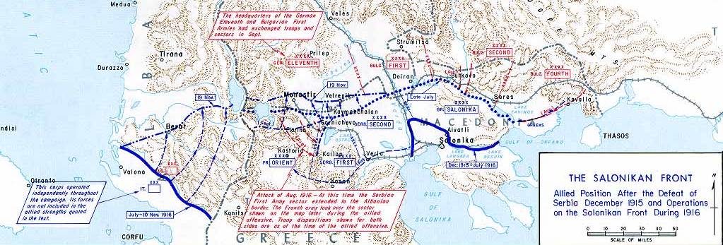
English: Operations at the border of Greece and Serbia, 1916.
his map was created by the Department of Military Art and Engineering, at the U.S. Military Academy (West Point). The initial version was created under the supervision of General Vincent Esposito in 1959. It is now available on the West Point |
||||||
| Дата | |||||||
| Крыніца | West Point | ||||||
| Аўтар | General Vincent Esposito | ||||||
| Дазвол (Паўторнае выкарыстанне гэтага файла) |
|
||||||
| Іншыя версіі |
  |
||||||

Гісторыя файла
Націснуць на даце з часам, каб паказаць файл, якім ён тады быў.
| Дата і час | Драбніца | Памеры | Удзельнік | Тлумачэнне | |
|---|---|---|---|---|---|
| актуальн. | 00:55, 22 снежня 2006 | 1 023 × 347 (99 KB) | Electionworld | {{ew|en|Cglassey}} == Summary == Operations at the border of Greece and Serbia, 1916. his map was created by the Department of Military Art and Engineering, at the U.S. Military Academy (West Point). The initial version was created under the supervision |
Выкарыстанне файла
Наступныя 2 старонкі выкарыстоўваюць гэты файл:
Глабальнае выкарыстанне файла
Гэты файл выкарыстоўваецца ў наступных вікі:
- Выкарыстанне ў ar.wikipedia.org
- Выкарыстанне ў azb.wikipedia.org
- Выкарыстанне ў az.wikipedia.org
- Выкарыстанне ў be-tarask.wikipedia.org
- Выкарыстанне ў bg.wikipedia.org
- Выкарыстанне ў bs.wikipedia.org
- Выкарыстанне ў ca.wikipedia.org
- Выкарыстанне ў de.wikipedia.org
- Выкарыстанне ў el.wikipedia.org
- Выкарыстанне ў en.wikipedia.org
- History of modern Macedonia (Greece)
- Maurice Sarrail
- Macedonian front
- Battle of Doiran (1917)
- Greece during World War I
- Monastir offensive
- Autonomous Province of Korçë
- Bulgarian occupation of Albania
- World War I in Albania
- Battle of the Crna Bend (1917)
- User:GerardM/Battles including the Ottoman Empire
- User:Falcaorib
- User:BoDr12/sandbox
- Выкарыстанне ў es.wikipedia.org
- Выкарыстанне ў fa.wikipedia.org
- Выкарыстанне ў fr.wikipedia.org
- Выкарыстанне ў he.wikipedia.org
- Выкарыстанне ў hr.wikipedia.org
- Выкарыстанне ў hu.wikipedia.org
- Выкарыстанне ў it.wikipedia.org
Паказаць глабальнае выкарыстанне гэтага файла.