
Файл:Taman map.png
Няма версіі з большай раздзяляльнасцю.
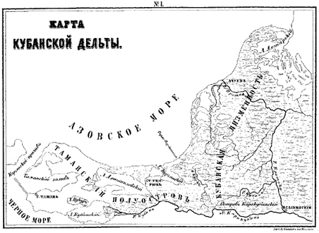
Taman_map.png (452 × 330 кропак, аб’ём файла: 33 KB, тып MIME: image/png)
Тлумачэнне
| Апісанне | A map of the Taman peninsula. |
| Крыніца | From Gerz, K. Arkheologicheskaya topografiya Tamanskogo poluostrova. Moscow: The Moscow Archaeological Society, 1870. |
| Аўтар |
Ліцэнзіяванне
This file is a Ukrainian or Ukrainian SSR work and it is presently in the public domain in Ukraine, because it was published before January 1, 1954, and the creator (if known) died before that date (details).
|
 |
This work is in the public domain in the United States because it was published (or registered with the U.S. Copyright Office) before January 1, 1929.
Public domain works must be out of copyright in both the United States and in the source country of the work in order to be hosted on the Commons. If the work is not a U.S. work, the file must have an additional copyright tag indicating the copyright status in the source country.
Note: This tag should not be used for sound recordings. |
Гісторыя файла
Націснуць на даце з часам, каб паказаць файл, якім ён тады быў.
| Дата і час | Драбніца | Памеры | Удзельнік | Тлумачэнне | |
|---|---|---|---|---|---|
| актуальн. | 09:44, 19 красавіка 2007 | | 452 × 330 (33 KB) | Joonasl | {{Information |Description=A map of the Taman peninsula. |Source=From Gerz, K. ''Arkheologicheskaya topografiya Tamanskogo poluostrova.'' Moscow: The Moscow Archaeological Society, 1870. |Date= |Author= |Permission= |other_versions= }} {{PD-Russia}} [[C |
Выкарыстанне файла
Няма старонак, якія выкарыстоўваюць гэты файл.
Глабальнае выкарыстанне файла
Гэты файл выкарыстоўваецца ў наступных вікі:
- Выкарыстанне ў az.wikipedia.org
- Выкарыстанне ў bg.wikipedia.org
- Выкарыстанне ў el.wikipedia.org
- Выкарыстанне ў en.wikipedia.org
- Выкарыстанне ў eo.wikipedia.org
- Выкарыстанне ў es.wikipedia.org
- Выкарыстанне ў fi.wikipedia.org
- Выкарыстанне ў fr.wikipedia.org
- Выкарыстанне ў hi.wikipedia.org
- Выкарыстанне ў hr.wikipedia.org
- Выкарыстанне ў hy.wikipedia.org
- Выкарыстанне ў id.wikipedia.org
- Выкарыстанне ў it.wikipedia.org
- Выкарыстанне ў ja.wikipedia.org
- Выкарыстанне ў ka.wikipedia.org
- Выкарыстанне ў la.wikipedia.org
- Выкарыстанне ў ml.wikipedia.org
- Выкарыстанне ў mt.wikipedia.org
- Выкарыстанне ў nn.wikipedia.org
- Выкарыстанне ў pt.wikipedia.org
- Выкарыстанне ў ru.wikipedia.org
- Выкарыстанне ў sh.wikipedia.org
- Выкарыстанне ў sl.wikipedia.org
- Выкарыстанне ў sr.wikipedia.org
- Выкарыстанне ў sv.wikipedia.org
- Выкарыстанне ў tr.wikipedia.org
- Выкарыстанне ў uk.wikipedia.org