
Файл:Atoll forming-i18.png

Памер папярэдняга прагляду: 412 × 599 пікселяў. Іншыя разрозненні: 165 × 240 пікселяў | 330 × 480 пікселяў | 528 × 768 пікселяў | 704 × 1 024 пікселяў | 1 667 × 2 423 пікселяў.
Арыгінальны файл (1 667 × 2 423 кропак, аб’ём файла: 486 KB, тып MIME: image/png)
Тлумачэнне
| Апісанне |
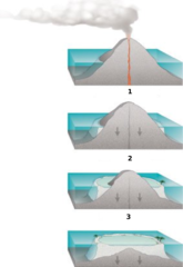
Internationalization of the diagram:Atoll forming. |
| Крыніца | http://commons.wikimedia.org/wiki/Image:Atoll_forming.jpg |
| Аўтар | Susan Mayfield and Sara Boore, modified by Eurico Zimbres |
| Дазвол (Паўторнае выкарыстанне гэтага файла) |
Free for all use |
| Іншыя версіі |
Derivative works of this file: |
Ліцэнзіяванне
This image is in the public domain in the United States because it only contains materials that originally came from the United States Geological Survey, an agency of the United States Department of the Interior. For more information, see the official USGS copyright policy.
|

|
This diagram image could be re-created using vector graphics as an SVG file. This has several advantages; see Commons:Media for cleanup for more information. If an SVG form of this image is available, please upload it and afterwards replace this template with
{{vector version available|new image name}}.
It is recommended to name the SVG file “Atoll forming-i18.svg”—then the template Vector version available (or Vva) does not need the new image name parameter. |
Гісторыя файла
Націснуць на даце з часам, каб паказаць файл, якім ён тады быў.
| Дата і час | Драбніца | Памеры | Удзельнік | Тлумачэнне | |
|---|---|---|---|---|---|
| актуальн. | 21:32, 29 мая 2006 | | 1 667 × 2 423 (486 KB) | Zimbres | {{Information |Description= Internationalization of the diagram:Atoll forming.<br> '''1'''=Volcanic Island<br> '''2'''=Fringind reef<br> '''3'''=Barrier reeef<br> |Source=http://commons.wikimedia.org/wiki/Image:Atoll_forming.jpg |Date= |Author=USGS/USGov |
Выкарыстанне файла
Наступная 1 старонка выкарыстоўвае гэты файл:
Глабальнае выкарыстанне файла
Гэты файл выкарыстоўваецца ў наступных вікі:
- Выкарыстанне ў az.wikipedia.org
- Выкарыстанне ў be-tarask.wikipedia.org
- Выкарыстанне ў es.wikipedia.org
- Выкарыстанне ў eu.wikipedia.org
- Выкарыстанне ў fi.wikipedia.org
- Выкарыстанне ў ja.wikipedia.org
- Выкарыстанне ў kbd.wikipedia.org
- Выкарыстанне ў lt.wikipedia.org
- Выкарыстанне ў mdf.wikipedia.org
- Выкарыстанне ў nn.wikipedia.org
- Выкарыстанне ў pl.wikipedia.org
- Выкарыстанне ў ru.wikipedia.org
- Выкарыстанне ў ru.wiktionary.org
- Выкарыстанне ў uk.wikipedia.org
- Выкарыстанне ў www.wikidata.org