
Файл:Balkans 6th century.svg

Памер гэтага PNG-прагляду для SVG-файла: 800 × 431 пікселяў. Іншыя разрозненні: 320 × 173 пікселяў | 640 × 345 пікселяў | 1 024 × 552 пікселяў | 1 280 × 690 пікселяў | 2 560 × 1 381 пікселяў | 1 400 × 755 пікселяў.
Арыгінальны файл (файл SVG, намінальна 1 400 × 755 кропак, аб’ём файла: 1,83 MB)
Тлумачэнне
| Апісанне |
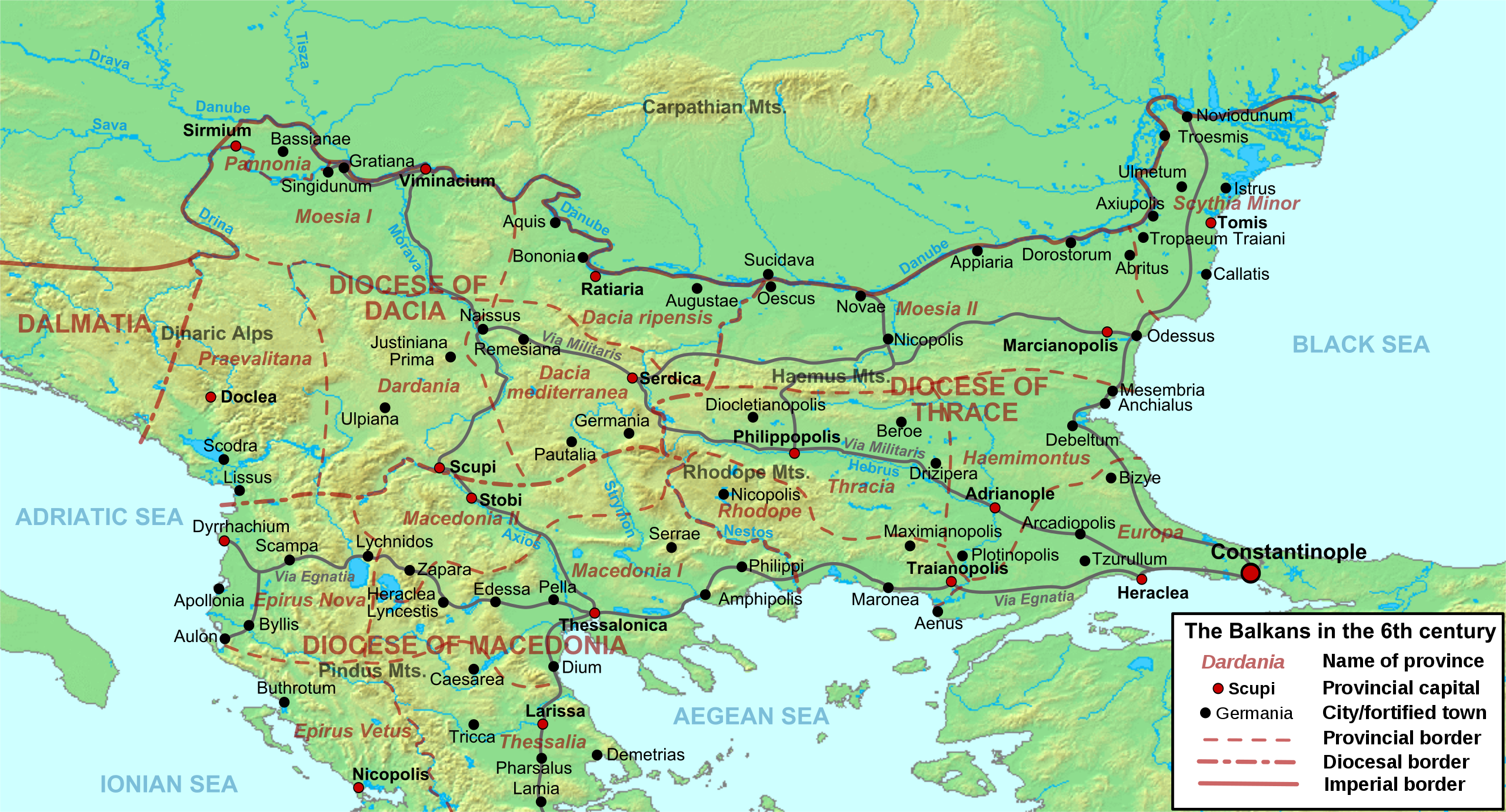
Deutsch: Die nördliche Balkanhalbinsel in der Spätantike (6. Jahrhundert), mit den spätrömischen Provinzen, Hauptsiedlungen und Straẞen.
English: Map of the northern Balkans in the 6th century AD, with the Roman provinces, major settlements and roads.
Français : Carte des Balkans septentrionaux au VIe siècle, à la veille de l'arrivée des Slaves, avec les provinces romains, les villes et les routes les plus importantes. |
| Дата | |
| Крыніца |
Уласная праца based on:
|
| Аўтар | Cplakidas |
| Іншыя версіі |
[]
|


Ліцэнзіяванне
Я, уладальнік аўтарскіх правоў на гэты твор, добраахвотна публікую яго на ўмовах наступных ліцэнзій:
Гэты файл даступны па ліцэнзіі Creative Commons Пазначэнне аўтарства - На тых самых умовах 3.0 Непартаваная
- Вы можаце свабодна:
- дзяліцца творам – капіраваць, распаўсюджваць і перадаваць гэты твор.
- ствараць вытворныя творы – адаптаваць гэты твор
- Пры выкананні наступных умоў:
- атрыбуцыя – вы павінны пазначыць аўтарства гэтага твора, даць спасылку на ліцэнзію і пазначыць ці рабіў аўтар якія-небудзь змены. Гэта можна рабіць кожным зразумелым чынам, але не так, каб наводзіць па думку, што ліцэнзіят падтрымлівае вас або выкарыстанне вамі гэтага твора.
- распаўсюджванне на тых жа ўмовах – Калі вы змяняеце, адаптуеце ці ствараеце вытворны твор на аснове гэтага, то павінны распаўсюджваць атрыманы ў выніку твор на ўмовах такой самай ці сумяшчальнай ліцэнзіі, што і арыгінал.

|
Дазваляецца капіяваць, распаўсюджваць і(або) мадыфікаваць гэты дакумент на ўмовах ліцэнзіі GNU FDL версіі 1.2 або навейшай, выдадзенай Фондам свабоднага праграмнага забеспячэння; без Нязменных раздзелаў, без тэкстаў Вокладак. Копія ліцэнзіі ёсць у раздзеле GNU Free Documentation License. |
Вы можаце выбраць любую з гэтых ліцэнзій.
Гісторыя файла
Націснуць на даце з часам, каб паказаць файл, якім ён тады быў.
| Дата і час | Драбніца | Памеры | Удзельнік | Тлумачэнне | |
|---|---|---|---|---|---|
| актуальн. | 12:52, 11 мая 2012 | | 1 400 × 755 (1,83 MB) | Cplakidas | corrected locations of Thracia and Haemimontus, minor tweaks elsewhere |
| 23:27, 7 студзеня 2012 |  | 1 400 × 755 (1,91 MB) | Cplakidas | Left-over names to paths | |
| 23:29, 1 сакавіка 2010 |  | 1 400 × 755 (2,1 MB) | Cplakidas | names to paths | |
| 23:20, 1 сакавіка 2010 |  | 1 400 × 755 (1,08 MB) | Cplakidas | {{Information |Description={{en|1=Map of the northern Balkans in the 6th century AD. Geophysical map taken from from [http://www2.demis.nl/mapserver/mapper.asp DEMIS Mapserver], which are public domain, other wise self-made. Sources: [http://soltdm.com/so |
Выкарыстанне файла
Наступная 1 старонка выкарыстоўвае гэты файл:
Глабальнае выкарыстанне файла
Гэты файл выкарыстоўваецца ў наступных вікі:
- Выкарыстанне ў ar.wikipedia.org
- Выкарыстанне ў azb.wikipedia.org
- Выкарыстанне ў bg.wikipedia.org
- Выкарыстанне ў bs.wikipedia.org
- Выкарыстанне ў cs.wikipedia.org
- Выкарыстанне ў de.wikipedia.org
- Выкарыстанне ў el.wikipedia.org
- Выкарыстанне ў en.wikipedia.org
- History of Albania
- 593
- Maurice (emperor)
- Moesia
- Dardani
- Serbia in the Middle Ages
- Pannonia (Byzantine province)
- Dacia Ripensis
- Dacia Mediterranea
- Dacia Aureliana
- Diocese of Dacia
- Praevalitana
- Peter (curopalates)
- Maurice's Balkan campaigns
- Dardania (Roman province)
- Ratiaria
- Via Militaris
- Comentiolus
- Albania under the Byzantine Empire
- List of ancient cities in Thrace and Dacia
Паказаць глабальнае выкарыстанне гэтага файла.