
Файл:Harz map.png

Памер папярэдняга прагляду: 800 × 482 пікселяў. Іншыя разрозненні: 320 × 193 пікселяў | 640 × 385 пікселяў | 1 024 × 617 пікселяў | 1 280 × 771 пікселяў | 2 529 × 1 523 пікселяў.
Арыгінальны файл (2 529 × 1 523 кропак, аб’ём файла: 3,15 MB, тып MIME: image/png)
Тлумачэнне
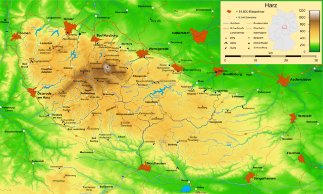
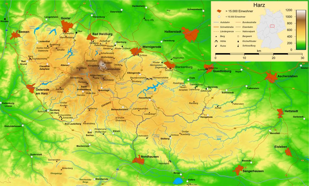
| Апісанне | Map of the Harz mountains in Germany with mountains, rivers, lakes, reservoirs, all highways, all Bundesstraßen, Harzquerbahn, Brockenbahn, Selketalbahn, major towns and sights. |
| Дата | |
| Крыніца | Уласная праца |
| Аўтар | Bamse |
| Іншыя версіі |
Derivative works of this file: Karte Harzer Schmalspurbahnen.png  , ,  , ,  |
The map has been created with the Generic Mapping Tools: https://www.generic-mapping-tools.org/ using one or more of these public-domain datasets for the relief:
|

|
Дазваляецца капіяваць, распаўсюджваць і(або) мадыфікаваць гэты дакумент на ўмовах ліцэнзіі GNU FDL версіі 1.2 або навейшай, выдадзенай Фондам свабоднага праграмнага забеспячэння; без Нязменных раздзелаў, без тэкстаў Вокладак. Копія ліцэнзіі ёсць у раздзеле GNU Free Documentation License. |
| Гэты файл даступны па ліцэнзіі Creative Commons Пазначэнне аўтарства - На тых самых умовах 3.0 Непартаваная | ||
| ||
| Гэтая картка дададзеная ў якасці часткі абнаўлення ліцэнзіі GFDL. |

|
This map has been made or improved in the German Kartenwerkstatt (Map Lab). You can propose maps to improve as well.
|
Гісторыя файла
Націснуць на даце з часам, каб паказаць файл, якім ён тады быў.
| Дата і час | Драбніца | Памеры | Удзельнік | Тлумачэнне | |
|---|---|---|---|---|---|
| актуальн. | 19:05, 15 снежня 2009 | | 2 529 × 1 523 (3,15 MB) | Bamse | update, B6n is completed |
| 09:12, 14 снежня 2007 |  | 2 529 × 1 523 (3,15 MB) | Bamse | {{Information |Description=Map of the Harz mountains in Germany with mountains, rivers, lakes, reservoirs, all highways, all Bundesstraßen, Harzquerbahn, Brockenbahn, [[:w:Selketalba | |
| 08:10, 19 верасня 2007 |  | 2 529 × 1 523 (3,14 MB) | Bamse | ||
| 05:33, 19 верасня 2007 |  | 2 529 × 1 523 (3,13 MB) | Bamse | {{Information |Description=Map of the w:Harz mountains in Germany. |Source=self-made |Date=19-09-2007 |Author= Bamse }} {{GFDL-GMT}} | |
| 11:21, 5 верасня 2007 |  | 2 529 × 1 523 (3,09 MB) | Bamse | {{Information |Description=Map of the w:Harz mountains in Germany. |Source=self-made |Date=05-09-2007 |Author= Bamse }} {{GFDL-GMT}} | |
| 09:02, 25 ліпеня 2007 |  | 2 532 × 1 527 (3 MB) | Bamse | {{Information |Description=Map of the w:Harz mountains in Germany. |Source=self-made |Date=25-07-2007 |Author= Bamse }} {{GFDL-GMT}} | |
| 13:30, 17 ліпеня 2007 |  | 2 529 × 1 526 (2,94 MB) | Bamse | {{Information |Description=Map of the w:Harz mountains in Germany. |Source=self-made |Date=17-07-2007 |Author= Bamse }} {{GFDL-GMT}} | |
| 14:42, 11 ліпеня 2007 |  | 2 529 × 1 523 (2,89 MB) | Bamse | {{Information |Description=Map of the w:Harz mountains in Germany. |Source=self-made |Date=11-07-2007 |Author= Bamse }} {{GFDL-GMT}} | |
| 13:21, 6 ліпеня 2007 |  | 2 529 × 1 523 (2,84 MB) | Bamse | {{Information |Description=Map of the w:Harz mountains in Germany. |Source=self-made |Date=06-07-2007 |Author= Bamse }} {{GFDL-GMT}} | |
| 05:48, 28 чэрвеня 2007 |  | 2 529 × 1 523 (2,77 MB) | Bamse | {{Information |Description=Map of the w:Harz mountains in Germany. |Source=self-made |Date=28-06-2007 |Author= Bamse }} {{GFDL-GMT}} |
Выкарыстанне файла
Наступная 1 старонка выкарыстоўвае гэты файл:
Глабальнае выкарыстанне файла
Гэты файл выкарыстоўваецца ў наступных вікі:
- Выкарыстанне ў ar.wikipedia.org
- Выкарыстанне ў bg.wikipedia.org
- Выкарыстанне ў br.wikipedia.org
- Выкарыстанне ў ca.wikipedia.org
- Выкарыстанне ў de.wikipedia.org
- Harz (Mittelgebirge)
- Harzer Hexenstieg
- Kaiserweg (Harz)
- Karstwanderweg
- Wikipedia:Kartenwerkstatt/Archiv/2007-09
- Liste von Bergen im Harz
- Wikipedia:Kandidaten für exzellente Bilder/Archiv2007/14
- Harzklippen
- Selketalstieg
- Benutzer:Ulflulfl/Karten
- Harzer Baudensteig
- Harzer Försterstieg
- Unterharzer Teich- und Grabensystem
- Portal:Harz
- Bode-Selke-Stieg
- Oberharzer Erzgänge
- Vorlage:Navigationsleiste Regionale Wanderwege im Harz
- Harzer Grenzweg
- Liste der Moore im Harz
- Harzer Klosterwanderweg
- Kaiser-Otto-Höhenweg
- Georgi Wladimirowitsch Iwanow
- Steinway Trail
- Teufelsstieg
- Gebietstausch 1945 im Harz
- Portal:Harz/Eingangstext
- Benutzer:D.W.Germann/Liste von Poststempeln im Harz
- Benutzer:D.W.Germann/Liste der Brockenkarten
- Benutzer:D.W.Germann/Eigenes/Mediensammlung
- Benutzer:D.W.Germann/Liste der Kartenwerke des Harzes
- Выкарыстанне ў en.wikipedia.org
- Выкарыстанне ў eo.wikipedia.org
- Выкарыстанне ў fi.wikipedia.org
- Выкарыстанне ў fr.wikipedia.org
- Выкарыстанне ў fr.wiktionary.org
- Выкарыстанне ў hu.wikipedia.org
- Выкарыстанне ў incubator.wikimedia.org
- Выкарыстанне ў is.wikipedia.org
- Выкарыстанне ў it.wikipedia.org
- Выкарыстанне ў ja.wikipedia.org
Паказаць глабальнае выкарыстанне гэтага файла.