
Файл:Khanate of Eriwan in 1809-1817.JPG
Арыгінальны файл (2 125 × 1 953 кропак, аб’ём файла: 433 KB, тып MIME: image/jpeg)
| Апісанне |
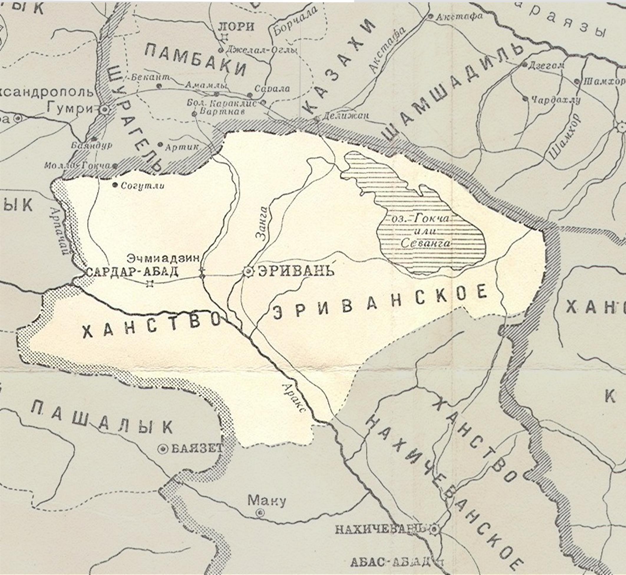
English: Persian khanate of Erivan in the map of Caucasus in 1809-1817 years
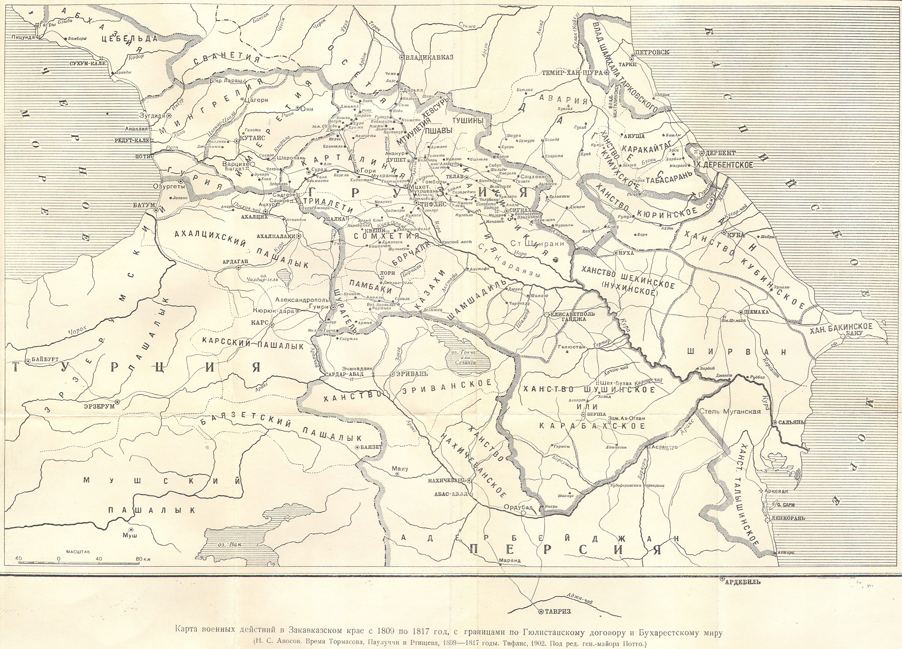
English: Map of military operations in the Transcaucasian region from 1809 to 1817(Карта военных действий в Закавказском крае с 1809 по 1817 год) |
||
| Дата | 1902, Тифлис | ||
| Крыніца |
|
||
| Аўтар | под редакцией ген.-майора Потто. Postwork by Interfase |
|
This work is in the public domain in its country of origin and other countries and areas where the copyright term is the author's life plus 70 years or fewer.
| |
| Гэты файл быў ідэнтыфікаваны як вольны ад вядомых абмежаванняў, згодна з законам аб аўтарскім праве, а таксама ад усіх сумежных правоў. | |
Гісторыя файла
Націснуць на даце з часам, каб паказаць файл, якім ён тады быў.
| Дата і час | Драбніца | Памеры | Удзельнік | Тлумачэнне | |
|---|---|---|---|---|---|
| актуальн. | 10:09, 28 верасня 2010 | | 2 125 × 1 953 (433 KB) | Interfase | {{Information |Description={{en|1=Azerbaijani khanate of Erivan in the map of Caucasus in 1809-1817 years (Карта военных действий в Закавказском крае с 1809 по 1817 год) }} |Source=http://www.runivers.ru/images/d |
Выкарыстанне файла
Наступная 1 старонка выкарыстоўвае гэты файл:
Глабальнае выкарыстанне файла
Гэты файл выкарыстоўваецца ў наступных вікі:
- Выкарыстанне ў azb.wikipedia.org
- Выкарыстанне ў az.wiktionary.org
- Выкарыстанне ў fi.wikipedia.org
- Выкарыстанне ў ru.wikipedia.org
- Эриванское ханство
- Шаблон:Эриванское ханство
- Зангибасарский магал
- Мечеть Залхана
- Мавзолей туркменских эмиров
- Сардарский дворец
- Хусейн-хан Каджар
- Ахмед-хан Мукаддам
- Амир Гюна-хан Каджар
- Гасан Али-хан Каджар
- Мечеть Аббаса Мирзы
- Список мечетей Армении
- Тахмасибгулу-хан Каджар
- Мехти-хан Касымлу
- Халил-хан Узбек
- Гусейн Али-хан
- Гуламали-хан Каджар
- Мухаммед-хан Каджар
- Мехти Кули-хан
- Гасан-хан Каджар
- Апаранский магал
- Ведибасарский магал
- Гарнибасарский магал
- Гёкчинский магал
- Гырхбулагский магал
- Дерекенд-Парченисский магал
- Деречичекский магал
- Кярбибасарский магал
- Саадлинский магал
- Сардарабадский магал
- Сеидли-Ахсаггалинский магал
- Сурмалинский магал
- Талинский магал
- Шарурский магал
- Мечеть Тапабаши
- Мечеть Реджепа-паши
- Мечеть шаха Аббаса
- Мечеть Сардара
- Мечеть Демирбулагская
- Мечеть Худабенде
- Мечеть Шукурбейли
- Мечеть Деф Султан
- Мечеть Мухаммеда Сертиб-хана
- Часовня Святого Апостола Анании
- Церковь Святой Богородицы (Канакер)
- Мухаммед-хан
- Кей-Хосров-хан Черкес
Паказаць глабальнае выкарыстанне гэтага файла.