
Файл:Kingdom of Germany 1004.svg

Памер гэтага PNG-прагляду для SVG-файла: 485 × 340 пікселяў. Іншыя разрозненні: 320 × 224 пікселяў | 640 × 449 пікселяў | 1 024 × 718 пікселяў | 1 280 × 897 пікселяў | 2 560 × 1 795 пікселяў.
Арыгінальны файл (файл SVG, намінальна 485 × 340 кропак, аб’ём файла: 1,23 MB)
Тлумачэнне
Гэты файл (вектарная выява) быў створаны з дапамогай Inkscape .


.svg)
.svg)
.svg)
.svg)
.svg)


.svg)
.svg)
.svg)


.png)
.png)


.svg)


.svg)

.svg)


.svg)
.svg)
.svg)
.svg)


.svg)
.png)


.svg)


.svg)
.svg)


.svg)


.svg)


.svg)
.svg)
.svg)
.svg)
.svg)
.svg)
.svg)
.svg)
_cropped.svg)
.svg)
.svg)
.svg)
.svg)
.svg)
.svg)
.svg)
.svg)
.svg)
.svg)
.svg)
.svg)
.svg)
.svg)
.svg)
.svg)
.svg)
.svg)
.svg)
.svg)
.svg)
.svg)
.svg)
.svg)
.svg)
.svg)
.svg)
.svg)
.svg)
.svg)
.svg)
.svg)
.svg)
.svg)
.svg)
.svg)
.svg)
.svg)
.svg)
.svg)
.svg)
.svg)
.svg)
.svg)
.svg)
Ліцэнзіяванне
Гэты файл даступны па ліцэнзіі Creative Commons Пазначэнне аўтарства - На тых самых умовах 3.0 Міжнародны
- Вы можаце свабодна:
- дзяліцца творам – капіраваць, распаўсюджваць і перадаваць гэты твор.
- ствараць вытворныя творы – адаптаваць гэты твор
- Пры выкананні наступных умоў:
- атрыбуцыя – вы павінны пазначыць аўтарства гэтага твора, даць спасылку на ліцэнзію і пазначыць ці рабіў аўтар якія-небудзь змены. Гэта можна рабіць кожным зразумелым чынам, але не так, каб наводзіць па думку, што ліцэнзіят падтрымлівае вас або выкарыстанне вамі гэтага твора.
- распаўсюджванне на тых жа ўмовах – Калі вы змяняеце, адаптуеце ці ствараеце вытворны твор на аснове гэтага, то павінны распаўсюджваць атрыманы ў выніку твор на ўмовах такой самай ці сумяшчальнай ліцэнзіі, што і арыгінал.
Гісторыя файла
Націснуць на даце з часам, каб паказаць файл, якім ён тады быў.
| Дата і час | Драбніца | Памеры | Удзельнік | Тлумачэнне | |
|---|---|---|---|---|---|
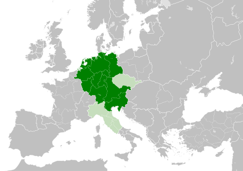
| актуальн. | 14:49, 4 мая 2021 | | 485 × 340 (1,23 MB) | E-960 | Tribute was paid under Mieszko I, by the year 1000 Bolesław I the Brave stopped paying it |
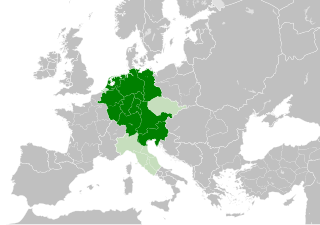
| 16:14, 23 мая 2016 |  | 485 × 340 (1,23 MB) | Der Golem | Duchy of Bohemia was part of the Holy Roman Empire, but not within the Kingdom of Germany | |
| 23:19, 22 мая 2016 |  | 485 × 340 (1,23 MB) | Alphathon | == {{int:filedesc}} == {{Inkscape}} {{Information |Description={{en|A map of the Kingdom of Germany within the Holy Roman Empire and within Europe circa 1004 CE, after the incorporation of the [[:en:Duchy of Bohemia|Duchy of... |
Выкарыстанне файла
Наступная 1 старонка выкарыстоўвае гэты файл:
Глабальнае выкарыстанне файла
Гэты файл выкарыстоўваецца ў наступных вікі:
- Выкарыстанне ў az.wikipedia.org
- Выкарыстанне ў ba.wikipedia.org
- Выкарыстанне ў ca.wikipedia.org
- Выкарыстанне ў cs.wikipedia.org
- Выкарыстанне ў en.wikipedia.org
- Выкарыстанне ў eo.wikipedia.org
- Выкарыстанне ў es.wikipedia.org
- Выкарыстанне ў et.wikipedia.org
- Выкарыстанне ў eu.wikipedia.org
- Выкарыстанне ў fr.wikipedia.org
- Выкарыстанне ў id.wikipedia.org
- Выкарыстанне ў ja.wikipedia.org
- Выкарыстанне ў ko.wikipedia.org
- Выкарыстанне ў la.wikipedia.org
- Выкарыстанне ў lv.wikipedia.org
- Выкарыстанне ў pl.wikipedia.org
- Выкарыстанне ў ru.wikipedia.org
- Выкарыстанне ў uk.wikipedia.org
- Выкарыстанне ў www.wikidata.org
.svg)