
Файл:Lithuania territory 1939-1940.svg

Памер гэтага PNG-прагляду для SVG-файла: 761 × 600 пікселяў. Іншыя разрозненні: 305 × 240 пікселяў | 609 × 480 пікселяў | 974 × 768 пікселяў | 1 280 × 1 009 пікселяў | 2 560 × 2 018 пікселяў | 2 479 × 1 954 пікселяў.
Арыгінальны файл (файл SVG, намінальна 2 479 × 1 954 кропак, аб’ём файла: 211 KB)
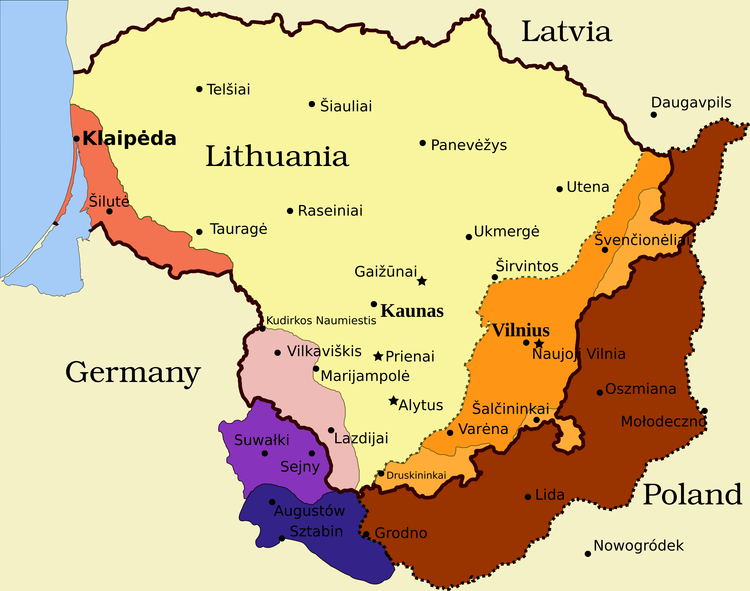
Legend
- Borders and other
Border of Lithuania (1945 – present)
Border of Vilnius Region: Polish territory; claimed by Lithuania based on the Soviet–Lithuania Peace Treaty of 1920; occupied by the Soviet Union in September 1939
![]() Soviet military bases established in Lithuania according to the Soviet–Lithuania Mutual Assistance Treaty, signed on October 10, 1939
Soviet military bases established in Lithuania according to the Soviet–Lithuania Mutual Assistance Treaty, signed on October 10, 1939
- Klaipėda Region
Klaipėda Region: detached from the German Empire by the Treaty of Versailles; placed under administration of the Entente; taken by Lithuanians during the Klaipėda Revolt in January 1923; returned to Nazi Germany after an ultimatum on March 20, 1939
- Sudovia
Territory west of the Šešupė River: Lithuanian territory; requested by Nazi Germany in the German-Soviet Boundary and Friendship Treaty on September 28, 1939; occupied by the Soviet Union on June 15, 1940; Nazi Germany relinquished its claims for a compensation in the amount of $7.5 million on January 10, 1941
"Suwałki Triangle": Polish territory; claimed by Lithuania; occupied by Nazi Germany in September 1939
Southern Suvalkai Region: Polish territory; claimed by Lithuania; occupied by the Soviet Union in September 1939
Vilnius Region
Western Vilnius Region: transferred to Lithuania based on the Soviet–Lithuania Mutual Assistance Treaty, signed on October 10, 1939
Western Vilnius Region: transferred to Lithuanian SSR on November 6, 1940
Eastern Vilnius Region: by Soviet–Lithuanian Peace Treaty assigned to Lithuania in July 12, 1920
Тлумачэнне
| Апісанне | Map of territorial disputes and claims regarding Lithuania in 1939-1940 |
| Дата | |
| Крыніца | Self-made using Inkscape; used Image:LithuaniaPhysicalMap-Clean.svg by Knutux for some background features; Source map: (2001) Lietuvos istorijos atlasas, Vilnius: Vaga, p. 44 & 45 |
| Аўтар |
Гэты файл (вектарная выява) быў створаны з дапамогай Inkscape . |
| Дазвол (Паўторнае выкарыстанне гэтага файла) |
GFDL & all CC-BY-SA |
| Іншыя версіі |
[]
|


Ліцэнзіяванне
Я, уладальнік аўтарскіх правоў на гэты твор, добраахвотна публікую яго на ўмовах наступных ліцэнзій:

|
Дазваляецца капіяваць, распаўсюджваць і(або) мадыфікаваць гэты дакумент на ўмовах ліцэнзіі GNU FDL версіі 1.2 або навейшай, выдадзенай Фондам свабоднага праграмнага забеспячэння; без Нязменных раздзелаў, без тэкстаў Вокладак. Копія ліцэнзіі ёсць у раздзеле GNU Free Documentation License. |
This file is licensed under the Creative Commons Attribution-Share Alike 4.0 International, 3.0 Unported, 2.5 Generic, 2.0 Generic and 1.0 Generic license.
- Вы можаце свабодна:
- дзяліцца творам – капіраваць, распаўсюджваць і перадаваць гэты твор.
- ствараць вытворныя творы – адаптаваць гэты твор
- Пры выкананні наступных умоў:
- атрыбуцыя – вы павінны пазначыць аўтарства гэтага твора, даць спасылку на ліцэнзію і пазначыць ці рабіў аўтар якія-небудзь змены. Гэта можна рабіць кожным зразумелым чынам, але не так, каб наводзіць па думку, што ліцэнзіят падтрымлівае вас або выкарыстанне вамі гэтага твора.
- распаўсюджванне на тых жа ўмовах – Калі вы змяняеце, адаптуеце ці ствараеце вытворны твор на аснове гэтага, то павінны распаўсюджваць атрыманы ў выніку твор на ўмовах такой самай ці сумяшчальнай ліцэнзіі, што і арыгінал.
Вы можаце выбраць любую з гэтых ліцэнзій.
Гісторыя файла
Націснуць на даце з часам, каб паказаць файл, якім ён тады быў.
| Дата і час | Драбніца | Памеры | Удзельнік | Тлумачэнне | |
|---|---|---|---|---|---|
| актуальн. | 14:13, 27 сакавіка 2024 | | 2 479 × 1 954 (211 KB) | X3SNW8 | File uploaded using svgtranslate tool (https://svgtranslate.toolforge.org/). Added translation for it. |
| 17:38, 20 жніўня 2010 |  | 2 479 × 1 954 (207 KB) | Tomasz Bladyniec | 1. There was an error in the name of one of villages. "Graizunai" should be "Gaizunai". 2. If the southeastern territory is decribed as Poland, names of cities should be in Polish then, as they were those times. 3. There's no need to write "Nazi Germany". | |
| 01:35, 31 сакавіка 2008 |  | 2 479 × 1 954 (203 KB) | Renata3 | get rid of legend - too bulky in articles | |
| 00:35, 31 сакавіка 2008 |  | 3 290 × 1 954 (226 KB) | Fvasconcellos | layers | |
| 17:22, 29 сакавіка 2008 |  | 3 290 × 1 954 (223 KB) | Fvasconcellos | font fixes | |
| 17:10, 29 сакавіка 2008 |  | 3 290 × 1 954 (210 KB) | Fvasconcellos | one more attempt | |
| 19:58, 28 сакавіка 2008 |  | 3 290 × 1 954 (226 KB) | Mangwanani | tried to fix image | |
| 19:28, 28 сакавіка 2008 |  | 3 290 × 1 954 (226 KB) | Renata3 | {{Information |Description=Map of territorial disputes and claims regarding Lithuania in 1939-1940 |Source=Self-made using Inkscape; used Image:LithuaniaPhysicalMap-Clean.svg by Knutux for some background features; Source map: (2001) ''Lietuvos istor |
Выкарыстанне файла
Наступныя 3 старонкі выкарыстоўваюць гэты файл:
Глабальнае выкарыстанне файла
Гэты файл выкарыстоўваецца ў наступных вікі:
- Выкарыстанне ў ar.wikipedia.org
- Выкарыстанне ў az.wikipedia.org
- Выкарыстанне ў be-tarask.wikipedia.org
- Выкарыстанне ў bg.wikipedia.org
- Выкарыстанне ў bn.wikipedia.org
- Выкарыстанне ў ca.wikipedia.org
- Выкарыстанне ў cs.wikipedia.org
- Выкарыстанне ў el.wikipedia.org
- Выкарыстанне ў en.wikipedia.org
- History of Lithuania
- Molotov–Ribbentrop Pact
- Vilnius Region
- Portal:Lithuania
- Talk:Sejny Uprising
- 1938 Polish ultimatum to Lithuania
- Wikipedia:Graphics Lab/Images to improve/Archive/Apr 2008
- Wikipedia:Articles for deletion/Log/2008 April 18
- Wikipedia:Articles for deletion/Suvalkai Region
- Soviet–Lithuanian Mutual Assistance Treaty
- German–Soviet Border and Commercial Agreement
- German occupation of Lithuania during World War II
- Soviet ultimatum to Lithuania
- Talk:Sejny Uprising/GA1
- Talk:The Holocaust in Poland/Archives/2018/April
- User:Falcaorib
- User:Artemis Andromeda/sandbox/Republic of Lithuania (1918–1940)
- Выкарыстанне ў es.wikipedia.org
- Выкарыстанне ў et.wikipedia.org
- Выкарыстанне ў fa.wikipedia.org
- Выкарыстанне ў fi.wikipedia.org
- Выкарыстанне ў fr.wikipedia.org
- Выкарыстанне ў hy.wikipedia.org
- Выкарыстанне ў id.wikipedia.org
- Выкарыстанне ў it.wikipedia.org
Паказаць глабальнае выкарыстанне гэтага файла.