
Файл:LocationSouthAfrica-1990.png
Няма версіі з большай раздзяляльнасцю.
LocationSouthAfrica-1990.png (250 × 115 кропак, аб’ём файла: 5 KB, тып MIME: image/png)

|
File:South Africa in its region (1990).svg is a vector version of this file. It should be used in place of this PNG file when not inferior.
File:LocationSouthAfrica-1990.png → File:South Africa in its region (1990).svg
For more information, see Help:SVG. |
.svg) |
Тлумачэнне
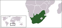
A locator map of South Africa showing en:Walvis Bay. This locator map is intended for South African articles taking place before the transfer of Walvis Bay to Namibia in 1994. The orginal map is by Vardion. Since that map is PD, this one is well.
Ліцэнзіяванне
| Гэты твор быў перададзены ў грамадскі набытак яго аутарам, Hoshie. Дазвол сапраўдны для ўсяго свету. У некаторых краінах гэта не можа быць юрыдычна магчыма; калі так, то: |
Гісторыя файла
Націснуць на даце з часам, каб паказаць файл, якім ён тады быў.
| Дата і час | Драбніца | Памеры | Удзельнік | Тлумачэнне | |
|---|---|---|---|---|---|
| актуальн. | 10:26, 17 снежня 2009 | | 250 × 115 (5 KB) | Hoshie | Reverted to version as of 03:34, 16 August 2006 rv, Nambia itself wasn't a part of S. Africa |
| 21:37, 2 снежня 2008 |  | 250 × 115 (5 KB) | ChrisDHDR | South Africa included Namibia at the time | |
| 06:34, 16 жніўня 2006 |  | 250 × 115 (5 KB) | Hoshie | == Summary == A locator map of South Africa showing en:Walvis Bay. This locator map is intended for South African articles taking place before the transfer of Walvis Bay to Nambia in 1994. The orginal map is by [[Us |
Выкарыстанне файла
Няма старонак, якія выкарыстоўваюць гэты файл.