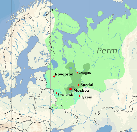
Файл:Muscovy 1390 1525.png
Muscovy_1390_1525.png (440 × 425 кропак, аб’ём файла: 135 KB, тып MIME: image/png)
Гісторыя файла
Націснуць на даце з часам, каб паказаць файл, якім ён тады быў.
| Дата і час | Драбніца | Памеры | Удзельнік | Тлумачэнне | |
|---|---|---|---|---|---|
| актуальн. | 19:20, 23 студзеня 2022 |  | 440 × 425 (135 KB) | Ориенталист | Reverted to version as of 16:40, 5 October 2020 (UTC) See File:Russo–Lithuanian Wars-1500 campaign-rus0.2.svg This territories became part of Russia during Ivan III |
| 13:09, 2 снежня 2021 |  | 440 × 425 (170 KB) | Dbachmann | Reverted to version as of 13:12, 17 April 2011 (UTC) -- I am sorry, please explain the change, you cannot just say "more accurate" without changing the references to the sources this is based on. | |
| 19:40, 5 кастрычніка 2020 |  | 440 × 425 (135 KB) | Ориенталист | More accurate | |
| 16:12, 17 красавіка 2011 |  | 440 × 425 (170 KB) | Dbachmann | update | |
| 15:42, 17 красавіка 2011 |  | 450 × 438 (212 KB) | Dbachmann | {{Information |Description ={{en|1=Grand Duchy of Moscow (Muscovy) between 1390 and 1547}} |Source =blank map: File:Europe location POR.png |Author =Dbachmann |Date =2011 |Permission = {{Copyrighted free use provided |
Выкарыстанне файла
Наступная 1 старонка выкарыстоўвае гэты файл:
Глабальнае выкарыстанне файла
Гэты файл выкарыстоўваецца ў наступных вікі:
- Выкарыстанне ў af.wikipedia.org
- Выкарыстанне ў arz.wikipedia.org
- Выкарыстанне ў ast.wikipedia.org
- Выкарыстанне ў ba.wikipedia.org
- Выкарыстанне ў be-tarask.wikipedia.org
- Выкарыстанне ў ca.wikipedia.org
- Выкарыстанне ў ce.wikipedia.org
- Выкарыстанне ў cs.wikipedia.org
- Выкарыстанне ў cy.wikipedia.org
- Выкарыстанне ў da.wikipedia.org
- Выкарыстанне ў de.wikipedia.org
- Выкарыстанне ў el.wikipedia.org
- Выкарыстанне ў en.wikipedia.org
- Выкарыстанне ў en.wikibooks.org
- Выкарыстанне ў en.wiktionary.org
- Выкарыстанне ў eo.wikipedia.org
- Выкарыстанне ў es.wikipedia.org
- Выкарыстанне ў et.wikipedia.org
- Выкарыстанне ў eu.wikipedia.org
- Выкарыстанне ў fa.wikipedia.org
- Выкарыстанне ў fi.wikipedia.org
- Выкарыстанне ў fr.wikipedia.org
- Выкарыстанне ў fy.wikipedia.org
Паказаць глабальнае выкарыстанне гэтага файла.


