
Файл:New York state geographic map-en.svg

Памер гэтага PNG-прагляду для SVG-файла: 800 × 569 пікселяў. Іншыя разрозненні: 320 × 228 пікселяў | 640 × 455 пікселяў | 1 024 × 729 пікселяў | 1 280 × 911 пікселяў | 2 560 × 1 821 пікселяў | 2 811 × 2 000 пікселяў.
Арыгінальны файл (файл SVG, намінальна 2 811 × 2 000 кропак, аб’ём файла: 18,34 MB)
Тлумачэнне
| Апісанне |
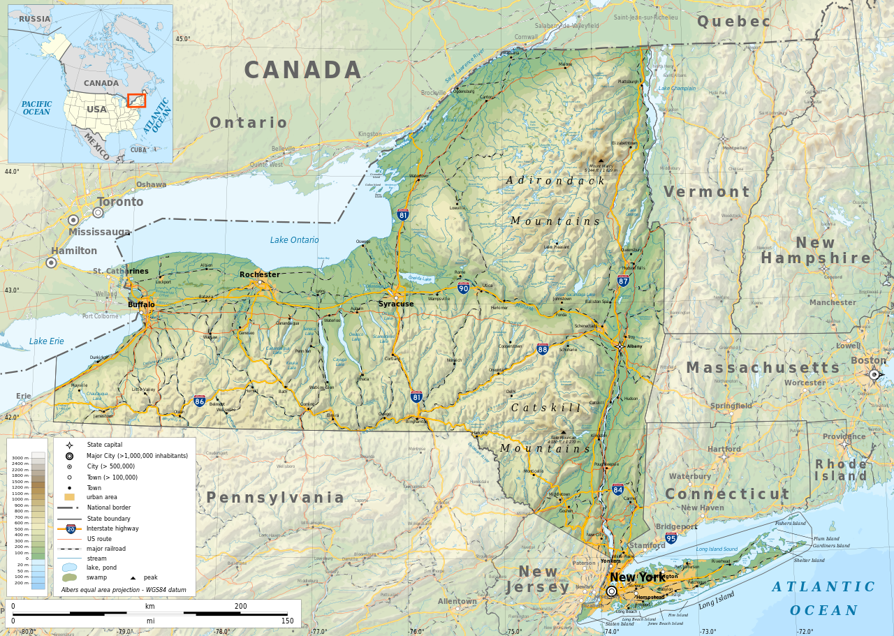
English: Geographic map of New York state in English. Geographic limits of the map:
|
| Дата | |
| Крыніца |
Уласная праца
|
| Стваральнік твора | |
| Дазвол (Паўторнае выкарыстанне гэтага файла) |
Any use of this map is subject of the license(s) stated below with the condition that you credit (Wikimedia Commons user: Ikonact) as the author . A message with a reply address would also be greatly appreciated. |
| Georeferencing | If inappropriate please set warp_status = skip to hide. |
|

|
This SVG file contains embedded text that can be translated into your language, using any capable SVG editor, text editor or the SVG Translate tool. For more information see: About translating SVG files. |
Ліцэнзіяванне
| This work contains information from OpenStreetMap, which is made available under the Open Database License (ODbL).
The ODbL does not require any particular license for maps produced from ODbL data. Prior to 1 August 2020, map tiles produced by the OpenStreetMap Foundation were licensed under the CC-BY-SA-2.0 license. Maps produced by other people may be subject to other licences. |
Я, уладальнік аўтарскіх правоў на гэты твор, добраахвотна публікую яго на ўмовах наступнай ліцэнзіі:
Гэты файл даступны па ліцэнзіі Creative Commons Пазначэнне аўтарства - На тых самых умовах 3.0 Міжнародны
- Вы можаце свабодна:
- дзяліцца творам – капіраваць, распаўсюджваць і перадаваць гэты твор.
- ствараць вытворныя творы – адаптаваць гэты твор
- Пры выкананні наступных умоў:
- атрыбуцыя – вы павінны пазначыць аўтарства гэтага твора, даць спасылку на ліцэнзію і пазначыць ці рабіў аўтар якія-небудзь змены. Гэта можна рабіць кожным зразумелым чынам, але не так, каб наводзіць па думку, што ліцэнзіят падтрымлівае вас або выкарыстанне вамі гэтага твора.
- распаўсюджванне на тых жа ўмовах – Калі вы змяняеце, адаптуеце ці ствараеце вытворны твор на аснове гэтага, то павінны распаўсюджваць атрыманы ў выніку твор на ўмовах такой самай ці сумяшчальнай ліцэнзіі, што і арыгінал.
Гісторыя файла
Націснуць на даце з часам, каб паказаць файл, якім ён тады быў.
| Дата і час | Драбніца | Памеры | Удзельнік | Тлумачэнне | |
|---|---|---|---|---|---|
| актуальн. | 15:15, 2 лістапада 2023 | | 2 811 × 2 000 (18,34 MB) | Ikonact | corrected some typos in names // Editing SVG source code using c:User:Rillke/SVGedit.js |
| 13:22, 14 кастрычніка 2019 |  | 2 811 × 2 000 (18,41 MB) | Ikonact | better dealing with fall back font | |
| 00:19, 13 кастрычніка 2019 |  | 2 811 × 2 000 (20,53 MB) | Ikonact | + fall back font, more towns and islands, provinces | |
| 02:33, 12 кастрычніка 2019 |  | 2 811 × 2 000 (20,47 MB) | Ikonact | error corrected | |
| 02:23, 12 кастрычніка 2019 |  | 2 811 × 2 000 (20,47 MB) | Ikonact | river and lake names added | |
| 00:58, 9 кастрычніка 2019 |  | 2 811 × 2 000 (20,33 MB) | Ikonact | some improvements, roads and cities in Canada | |
| 10:40, 22 верасня 2019 |  | 2 811 × 2 000 (14,39 MB) | Ikonact | small corrections | |
| 23:49, 21 верасня 2019 |  | 2 811 × 2 000 (14,39 MB) | Ikonact | + road names | |
| 23:23, 21 верасня 2019 |  | 2 811 × 2 000 (14,31 MB) | Ikonact | +names | |
| 01:01, 21 верасня 2019 |  | 2 811 × 2 000 (15,37 MB) | Ikonact | == {{int:filedesc}} == {{Information |description={{en|1=Geographic map of New York state in English. Geographic limits of the map:}} *N: 45.30° N *S: 40.30° N *W: 80.20° W *E: 71.00° W Albers equal area projection; WGS 84 datum |date=2019-09-21 |source={{own}} *Sources of data:<br/> **Topography: ETOPO1 (public domain);<br/> **Public domain data provided by the National Atlas of the United States of America;<br/> *Tool:<br/> **The map is created with Octave scripts d... |
Выкарыстанне файла
Наступная 1 старонка выкарыстоўвае гэты файл:
Глабальнае выкарыстанне файла
Гэты файл выкарыстоўваецца ў наступных вікі:
- Выкарыстанне ў af.wikipedia.org
- Выкарыстанне ў ang.wikipedia.org
- Выкарыстанне ў az.wikipedia.org
- Выкарыстанне ў bg.wikipedia.org
- Выкарыстанне ў bn.wikipedia.org
- Выкарыстанне ў ca.wikipedia.org
- Выкарыстанне ў en.wikipedia.org
- Выкарыстанне ў eo.wikipedia.org
- Выкарыстанне ў fr.wikipedia.org
- Выкарыстанне ў ga.wikipedia.org
- Выкарыстанне ў gl.wikipedia.org
- Выкарыстанне ў ha.wikipedia.org
- Выкарыстанне ў hu.wikipedia.org
- Выкарыстанне ў hy.wikipedia.org
- Выкарыстанне ў id.wikipedia.org
- Выкарыстанне ў lt.wikipedia.org
- Выкарыстанне ў mhr.wikipedia.org
- Выкарыстанне ў ml.wikipedia.org
- Выкарыстанне ў os.wikipedia.org
- Выкарыстанне ў pcd.wikipedia.org
- Выкарыстанне ў pl.wikipedia.org
- Выкарыстанне ў sh.wikipedia.org
- Выкарыстанне ў tg.wikipedia.org
- Выкарыстанне ў tr.wikipedia.org
- Выкарыстанне ў tt.wikipedia.org
- Выкарыстанне ў uk.wikipedia.org
- Выкарыстанне ў www.wikidata.org