
Файл:Physical map of the Kingdom of Hungary before 1919.jpg

Памер папярэдняга прагляду: 790 × 600 пікселяў. Іншыя разрозненні: 316 × 240 пікселяў | 633 × 480 пікселяў | 1 012 × 768 пікселяў | 1 280 × 971 пікселяў | 2 423 × 1 839 пікселяў.
Арыгінальны файл (2 423 × 1 839 кропак, аб’ём файла: 5,73 MB, тып MIME: image/jpeg)
Тлумачэнне
Тлумачэнне
| Апісанне |
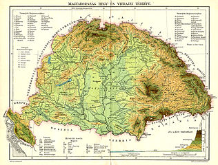
English: Hydro- geological Map of Hungary Magyar: Magyarország hegy- és vízrajzi térképe |
| Дата | |
| Крыніца |
English: Great Encyclopedia of Révai Magyar: Révai nagy lexikona |
| Аўтар | dr. Bodnár Gyula (1882–1948) |
Ліцэнзіяванне
|
The author died in 1948, so this work is in the public domain in its country of origin and other countries and areas where the copyright term is the author's life plus 75 years or fewer. This work is in the public domain in the United States because it was published (or registered with the U.S. Copyright Office) before January 1, 1929. | |
| Гэты файл быў ідэнтыфікаваны як вольны ад вядомых абмежаванняў, згодна з законам аб аўтарскім праве, а таксама ад усіх сумежных правоў. | |
Гісторыя файла
Націснуць на даце з часам, каб паказаць файл, якім ён тады быў.
| Дата і час | Драбніца | Памеры | Удзельнік | Тлумачэнне | |
|---|---|---|---|---|---|
| актуальн. | 10:43, 23 кастрычніка 2015 | | 2 423 × 1 839 (5,73 MB) | Hello world | new |
| 04:59, 25 красавіка 2014 |  | 1 719 × 1 305 (612 KB) | CSvBibra | general clean up | |
| 11:43, 28 кастрычніка 2010 |  | 1 719 × 1 305 (559 KB) | Szilas | == Summary == {{int:filedesc}} {{Information |Description={{en|Physical map of the Kingdom of Hungary before 1919}}{{hu|A Magyar Királyság hegy- és vízrajzi térképe 1919 előtt}}| |Source = {{en|Great Encyclopedia of Révai}}{{hu|Révai nagy le |
Выкарыстанне файла
Наступная 1 старонка выкарыстоўвае гэты файл:
Глабальнае выкарыстанне файла
Гэты файл выкарыстоўваецца ў наступных вікі:
- Выкарыстанне ў ba.wikipedia.org
- Выкарыстанне ў cs.wikipedia.org
- Выкарыстанне ў hu.wikipedia.org
- Выкарыстанне ў nl.wikipedia.org
- Выкарыстанне ў sh.wikipedia.org
- Выкарыстанне ў sk.wikipedia.org