
Файл:Remains of Nero's Isthmus Canal in 1881.jpg

Памер папярэдняга прагляду: 800 × 507 пікселяў. Іншыя разрозненні: 320 × 203 пікселяў | 640 × 405 пікселяў | 1 200 × 760 пікселяў.
Арыгінальны файл (1 200 × 760 кропак, аб’ём файла: 225 KB, тып MIME: image/jpeg)
Тлумачэнне
| Апісанне |
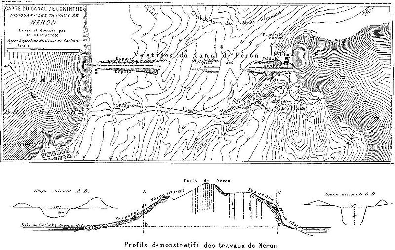
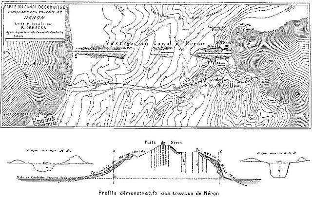
Deutsch: Überreste von Neros Projekt, einen Kanal durch den Isthmus von Korinth zu stechen (67 n. Chr.). Die dunkel schraffierten Bereiche markieren die antiken Aushubarbeiten. Die senkrechten Schächte im Bild unten dienten den Römern zur Begutachtung des Steinmaterials in der Tiefe. Die Karte wurde vom Chefingenieur des modernen Kanalprojekts Bela Gerster 1881 bei der Erkundung der Landenge angefertigt.
English: Remains of Nero's aborted project to cut through the Isthmus of Corinth (67 AD). The Roman digging is indicated by the dark shaded areas. The vertical shafts in the cross section below were excavated by the Romans to probe the stone material. The map was drawn by chief engineer Bela Gerster in 1881 during his survey for the modern canal. |
| Дата | |
| Крыніца | Werner, Walter: "The largest ship trackway in ancient times: the Diolkos of the Isthmus of Corinth, Greece, and early attempts to build a canal", The International Journal of Nautical Archaeology, Vol. 26, No. 2 (1997), pp. 98–119 (114, Fig. 25) |
| Аўтар | Bela Gerster (1850–1923) |
| Іншыя версіі |
.jpg)

|
This old map image could be re-created using vector graphics as an SVG file. This has several advantages; see Commons:Media for cleanup for more information. If an SVG form of this image is available, please upload it and afterwards replace this template with
{{vector version available|new image name}}.
It is recommended to name the SVG file “Remains of Nero's Isthmus Canal in 1881.svg”—then the template Vector version available (or Vva) does not need the new image name parameter. |


Ліцэнзіяванне
|
The author died in 1923, so this work is in the public domain in its country of origin and other countries and areas where the copyright term is the author's life plus 100 years or fewer. This work is in the public domain in the United States because it was published (or registered with the U.S. Copyright Office) before January 1, 1929. | |
| Гэты файл быў ідэнтыфікаваны як вольны ад вядомых абмежаванняў, згодна з законам аб аўтарскім праве, а таксама ад усіх сумежных правоў. | |
Гісторыя файла
Націснуць на даце з часам, каб паказаць файл, якім ён тады быў.
| Дата і час | Драбніца | Памеры | Удзельнік | Тлумачэнне | |
|---|---|---|---|---|---|
| актуальн. | 19:46, 15 студзеня 2008 | | 1 200 × 760 (225 KB) | Gun Powder Ma | == Summary == {{Information |Description= {{de| Überreste von Neros Projekt, einen Kanal durch den Isthmus von Korinth zu stechen. Die Karte wurde vom Chefingenieur des modernen Kanalprojekts Bela Gerster 1881 bei der Erkundung der Landenge gezeichnet. D |
| 19:38, 15 студзеня 2008 |  | 751 × 476 (102 KB) | Gun Powder Ma | {{Information |Description= {{de| Überreste von Neros Projekt, einen Kanal durch den Isthmus von Korinth zu stechen. Die Karte wurde vom Chefingenieur des modernen Kanalprojekts Bela Gerster 1881 bei der Erkundung der Landenge gezeichnet. Die senkrechten |
Выкарыстанне файла
Наступная 1 старонка выкарыстоўвае гэты файл:
Глабальнае выкарыстанне файла
Гэты файл выкарыстоўваецца ў наступных вікі:
- Выкарыстанне ў als.wikipedia.org
- Выкарыстанне ў az.wikipedia.org
- Выкарыстанне ў bg.wikipedia.org
- Выкарыстанне ў da.wikipedia.org
- Выкарыстанне ў de.wikipedia.org
- Выкарыстанне ў en.wikipedia.org
- Выкарыстанне ў es.wikipedia.org
- Выкарыстанне ў et.wikipedia.org
- Выкарыстанне ў fi.wikipedia.org
- Выкарыстанне ў fr.wikipedia.org
- Выкарыстанне ў hyw.wikipedia.org
- Выкарыстанне ў it.wikipedia.org
- Выкарыстанне ў nn.wikipedia.org
- Выкарыстанне ў no.wikipedia.org
- Выкарыстанне ў ro.wikipedia.org
- Выкарыстанне ў ru.wikipedia.org
- Выкарыстанне ў sk.wikipedia.org
- Выкарыстанне ў sl.wikipedia.org
- Выкарыстанне ў sq.wikipedia.org
- Выкарыстанне ў sv.wikipedia.org
- Выкарыстанне ў tr.wikipedia.org
- Выкарыстанне ў uk.wikipedia.org
- Выкарыстанне ў vi.wikipedia.org