
Файл:Tectonic plates Caribbean.png

Памер папярэдняга прагляду: 800 × 600 пікселяў. Іншыя разрозненні: 320 × 240 пікселяў | 640 × 480 пікселяў | 1 024 × 768 пікселяў.
Арыгінальны файл (1 024 × 768 кропак, аб’ём файла: 64 KB, тып MIME: image/png)
Transferred from en.wikipedia to Commons by Maksim.
The original description page was here. All following user names refer to en.wikipedia.
| Я, уладальнік аўтарскіх правоў на гэты твор, перадаю яго ў грамадскі набытак. Дазвол сапраўдны для ўсяго свету. У некаторых краінах гэта не можа быць юрыдычна магчыма; калі так, то: Я дазваляю кожнаму выкарыстоўваць гэтую працу ў любых мэтах, без аніякіх умоваў, калі толькі такія ўмовы не патрабуюцца паводле закону. |
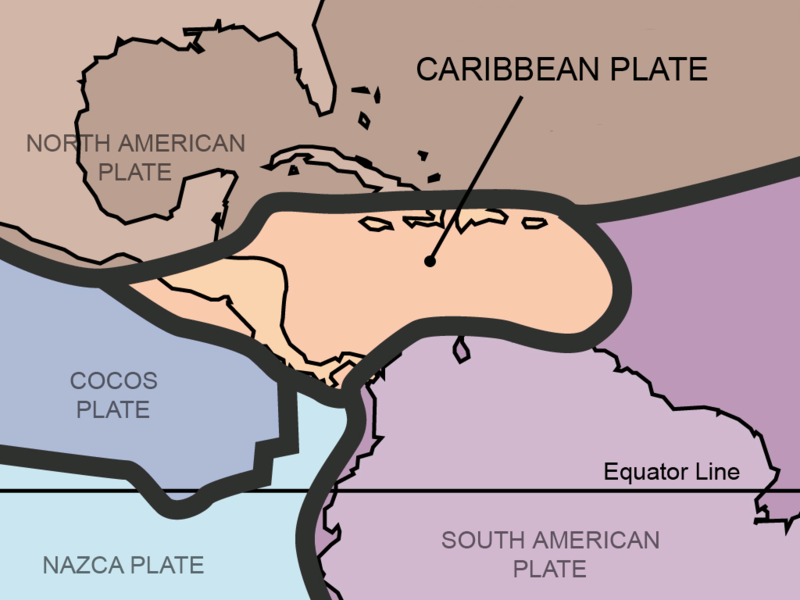
This work was derived from Image:Tectonic_plates.png, an image in the public domain (PD-USGov-Interior-USGS).
| date/time | username | edit summary |
|---|---|---|
| 17:17, 9 July 2005 | en:User:Gruepig | (public domain (derived from USGS work)) |
| 17:07, 9 July 2005 | en:User:Gruepig |

|
This geology image could be re-created using vector graphics as an SVG file. This has several advantages; see Commons:Media for cleanup for more information. If an SVG form of this image is available, please upload it and afterwards replace this template with
{{vector version available|new image name}}.
It is recommended to name the SVG file “Tectonic plates Caribbean.svg”—then the template Vector version available (or Vva) does not need the new image name parameter. |
- File:Plates tect2 en.svg would be useful as a starting point for a SVG
Журнал арыгінальнай загрузкі
Legend: (cur) = this is the current file, (del) = delete this old version, (rev) = revert to this old version.
Click on date to download the file or see the image uploaded on that date.
- (del) (cur) 17:07, 9 July 2005 . . en:User:Gruepig Gruepig ( en:User_talk:Gruepig Talk) . . 3000x2250 (1157305 bytes)
Гісторыя файла
Націснуць на даце з часам, каб паказаць файл, якім ён тады быў.
| Дата і час | Драбніца | Памеры | Удзельнік | Тлумачэнне | |
|---|---|---|---|---|---|
| актуальн. | 04:32, 16 лютага 2013 | | 1 024 × 768 (64 KB) | JohnnyMrNinja | reduce size over 3x with color indexing and slightly higher compression |
| 23:51, 31 жніўня 2011 |  | 1 024 × 768 (211 KB) | AlexCovarrubias | Centered map on the Caribbean Plate. | |
| 19:30, 5 лютага 2006 |  | 3 000 × 2 250 (1,1 MB) | Maksim | La bildo estas kopiita de wikipedia:en. La originala priskribo estas: {{PD-self}} This work was derived from Image:Tectonic_plates.png, an image in the public domain (PD-USGov-Interior-USGS). {| border="1" ! date/time || username || edit summary |---- |
Выкарыстанне файла
Наступная 1 старонка выкарыстоўвае гэты файл:
Глабальнае выкарыстанне файла
Гэты файл выкарыстоўваецца ў наступных вікі:
- Выкарыстанне ў ar.wikipedia.org
- Выкарыстанне ў bo.wikipedia.org
- Выкарыстанне ў bs.wikipedia.org
- Выкарыстанне ў ca.wikipedia.org
- Выкарыстанне ў da.wikipedia.org
- Выкарыстанне ў de.wikipedia.org
- Выкарыстанне ў en.wikipedia.org
- Выкарыстанне ў eo.wikipedia.org
- Выкарыстанне ў es.wikipedia.org
- Выкарыстанне ў eu.wikipedia.org
- Выкарыстанне ў fa.wikipedia.org
- Выкарыстанне ў fi.wikipedia.org
- Выкарыстанне ў fr.wikipedia.org
- Выкарыстанне ў fy.wikipedia.org
- Выкарыстанне ў ga.wikipedia.org
- Выкарыстанне ў he.wikipedia.org
- Выкарыстанне ў hi.wikipedia.org
- Выкарыстанне ў hu.wikipedia.org
- Выкарыстанне ў hy.wikipedia.org
- Выкарыстанне ў id.wikipedia.org
- Выкарыстанне ў it.wikipedia.org
- Выкарыстанне ў ja.wikipedia.org
- Выкарыстанне ў ka.wikipedia.org
- Выкарыстанне ў km.wikipedia.org
Паказаць глабальнае выкарыстанне гэтага файла.