
Файл:Tribal Kingdom of Samo-sl version.PNG

Памер папярэдняга прагляду: 601 × 600 пікселяў. Іншыя разрозненні: 241 × 240 пікселяў | 481 × 480 пікселяў | 852 × 850 пікселяў.
Арыгінальны файл (852 × 850 кропак, аб’ём файла: 149 KB, тып MIME: image/png)
| Апісанне |
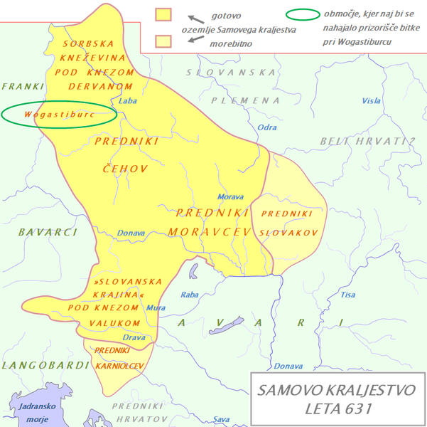
English: Tribal Kingdom of Samo. Map is based on the maps in: Korošec, Paola (1990): Alpski Slovani- Die Alpenslawen, Ljubljana, Znanstveni institut Filozofske fakultete, unnamed map on the page 18; Šavli, Jožko (1995): Sovenija: Podoba evropskega naroda, Bilje, založba Humar, map Samovo kraljestvo on the page 19; Barford, Paul M. (2001): The Early Slavs, Cornell University Press, map on the page 356, named Geography of the Slav settlement of Polabia- concerning the location of Sorbs east of Saale; map IV on page 397 for Sorbian culture, Devinska-Nova ves culture and Avarian state. It is also based on descriptions in: Štih, Peter (2001): Ozemlje Slovenije v zgodnjem srednjem veku: osnovne poteze zgodovinskega razvoja od začetka 6. do konca 9. stoletja, Ljubljana, Filozofska fakulteta; page 30- concerning the relationsship between king Samo and the ancestros of Slovenians; Korošec, Paola (1990): Alpski Slovani- Die Alpenslawen, Ljubljana, Znanstveni institut Filozofske fakultete, page 17 – concerning the Sorbs and their duke Dervan. For eastern and southern extant of tribal kingdom: known territories are shown by the scheme of franco-slavic border and information about the conflicts with Avars is imlemented. The inclusion of Bohemian basin is followed. Contacts with Avars are reached through the territory of Moravians anf Eastern Alps. The territories further east and south, which are in proximity of Avars, could be parts of tribal kingdom, too. |
| Дата | (UTC) |
| Крыніца | |
| Аўтар |
|
| This is a retouched picture, which means that it has been digitally altered from its original version. Modifications: The map of Danube basin was used to create map of Kingdom of Samo. The original can be viewed here: Waterways of SE Central Europe.svg:
|
Я, уладальнік аўтарскіх правоў на гэты твор, добраахвотна публікую яго на ўмовах наступнай ліцэнзіі:
| Я, уладальнік аўтарскіх правоў на гэты твор, перадаю яго ў грамадскі набытак. Дазвол сапраўдны для ўсяго свету. У некаторых краінах гэта не можа быць юрыдычна магчыма; калі так, то: Я дазваляю кожнаму выкарыстоўваць гэтую працу ў любых мэтах, без аніякіх умоваў, калі толькі такія ўмовы не патрабуюцца паводле закону. |
Журнал арыгінальнай загрузкі
This image is a derivative work of the following images:
- File:Waterways_of_SE_Central_Europe.svg licensed with PD-self
- 2010-01-08T20:49:27Z Kmiki87 1415x1059 (292577 Bytes) {{Information |Description={{en|1=Waterways along the central and lower Danube, including the Bohemian and Carpathian Basins, the northern Balkans, parts of Austria, southern Poland and Western Ukraine.}} |Source={{own}} |Aut
Uploaded with derivativeFX
Гісторыя файла
Націснуць на даце з часам, каб паказаць файл, якім ён тады быў.
| Дата і час | Драбніца | Памеры | Удзельнік | Тлумачэнне | |
|---|---|---|---|---|---|
| актуальн. | 21:21, 9 студзеня 2011 | | 852 × 850 (149 KB) | Bostjan46 | The text for Dalmatian Slavs was changed (Slavic tribes under avarian rule>>Ancestors of Croats). |
| 20:13, 9 студзеня 2011 |  | 852 × 850 (150 KB) | Bostjan46 | {{Information |Description={{en|1=Tribal Kingdom of Samo. Map is based on the maps in: Korošec, Paola (1990): ''Alpski Slovani- Die Alpenslawen'', Ljubljana, Znanstveni institut Filozofske fakultete, unnamed map on the page 18; Šavli, Jožko (1995): '' |
Выкарыстанне файла
Наступная 1 старонка выкарыстоўвае гэты файл:
Глабальнае выкарыстанне файла
Гэты файл выкарыстоўваецца ў наступных вікі:
- Выкарыстанне ў az.wikipedia.org
- Выкарыстанне ў bg.wikipedia.org
- Выкарыстанне ў de.wikipedia.org
- Выкарыстанне ў gl.wikipedia.org
- Выкарыстанне ў lt.wikipedia.org
- Выкарыстанне ў pl.wikipedia.org
- Выкарыстанне ў ru.wikipedia.org
- Выкарыстанне ў sl.wikipedia.org
- Выкарыстанне ў sr.wikipedia.org
- Выкарыстанне ў sv.wikipedia.org
- Выкарыстанне ў szl.wikipedia.org