
Файл:Baton Rouge Louisiana waterfront aerial view.jpg
Памер папярэдняга прагляду: 750 × 600 пікселяў. Іншыя разрозненні: 300 × 240 пікселяў | 600 × 480 пікселяў | 960 × 768 пікселяў | 1 280 × 1 024 пікселяў | 1 500 × 1 200 пікселяў.
Арыгінальны файл (1 500 × 1 200 кропак, аб’ём файла: 1,04 MB, тып MIME: image/jpeg)
| Апісанне |
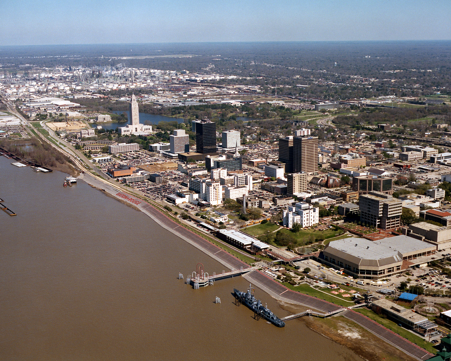
English: Aerial view of the riverfront area of Baton Rouge, Louisiana, USA. The city fronts on the Mississippi River in the center of Louisiana. The tall state capitol tower can be seen at center left. The historic destroyer USS Kidd is moored in the river at the bottom of the picture. View is to the north-northeast. |
|||
| Дата | ||||
| Крыніца |
U.S. Army Corps of Engineers Digital Visual Library Image page Image description page Digital Visual Library home page |
|||
| Аўтар | Michael Maples, U.S. Army Corps of Engineers | |||
| Дазвол (Паўторнае выкарыстанне гэтага файла) |
|
|||
| Location | Baton Rouge, Louisiana, USA |
| Camera location | | View this and other nearby images on: OpenStreetMap |
|---|
Гісторыя файла
Націснуць на даце з часам, каб паказаць файл, якім ён тады быў.
| Дата і час | Драбніца | Памеры | Удзельнік | Тлумачэнне | |
|---|---|---|---|---|---|
| актуальн. | 06:05, 6 красавіка 2007 | | 1 500 × 1 200 (1,04 MB) | DanMS | {{Information | Description = {{en|Aerial view of the riverfront area of Baton Rouge, Louisiana, USA. The ctiy fronts on the Mississippi River in the center of Louisiana. The tall state capital tower can be seen at center left. The historic destroyer U |
Выкарыстанне файла
Наступная 1 старонка выкарыстоўвае гэты файл:
Глабальнае выкарыстанне файла
Гэты файл выкарыстоўваецца ў наступных вікі:
- Выкарыстанне ў af.wikipedia.org
- Выкарыстанне ў an.wikipedia.org
- Выкарыстанне ў ar.wikipedia.org
- Выкарыстанне ў arz.wikipedia.org
- Выкарыстанне ў ast.wikipedia.org
- Выкарыстанне ў az.wikipedia.org
- Выкарыстанне ў bat-smg.wikipedia.org
- Выкарыстанне ў be-tarask.wikipedia.org
- Выкарыстанне ў bg.wikipedia.org
- Выкарыстанне ў br.wikipedia.org
- Выкарыстанне ў ca.wikipedia.org
- Выкарыстанне ў ceb.wikipedia.org
- Выкарыстанне ў ce.wikipedia.org
- Выкарыстанне ў cy.wikipedia.org
- Выкарыстанне ў dag.wikipedia.org
- Выкарыстанне ў da.wikipedia.org
- Выкарыстанне ў de.wikipedia.org
- Выкарыстанне ў de.wikivoyage.org
- Выкарыстанне ў diq.wikipedia.org
- Выкарыстанне ў el.wikipedia.org
- Выкарыстанне ў en.wikipedia.org
- Выкарыстанне ў en.wikinews.org
- Выкарыстанне ў en.wikivoyage.org
- Выкарыстанне ў en.wiktionary.org
- Выкарыстанне ў es.wikipedia.org
- Выкарыстанне ў et.wikipedia.org
- Выкарыстанне ў eu.wikipedia.org
- Выкарыстанне ў fi.wikipedia.org
- Выкарыстанне ў fr.wikipedia.org
- Выкарыстанне ў fr.wikivoyage.org
- Выкарыстанне ў fy.wikipedia.org
- Выкарыстанне ў ga.wikipedia.org
- Выкарыстанне ў gl.wikipedia.org
- Выкарыстанне ў he.wikipedia.org
- Выкарыстанне ў he.wikivoyage.org
- Выкарыстанне ў hsb.wikipedia.org
- Выкарыстанне ў ht.wikipedia.org
- Выкарыстанне ў hu.wikipedia.org
Паказаць глабальнае выкарыстанне гэтага файла.