
Файл:Dardanelles defences 1915.png
Памер папярэдняга прагляду: 580 × 599 пікселяў. Іншыя разрозненні: 232 × 240 пікселяў | 600 × 620 пікселяў.
Арыгінальны файл (600 × 620 кропак, аб’ём файла: 137 KB, тып MIME: image/png)

|
This map image could be re-created using vector graphics as an SVG file. This has several advantages; see Commons:Media for cleanup for more information. If an SVG form of this image is available, please upload it and afterwards replace this template with
{{vector version available|new image name}}.
It is recommended to name the SVG file “Dardanelles defences 1915.svg”—then the template Vector version available (or Vva) does not need the new image name parameter. |
Тлумачэнне
| Апісанне |
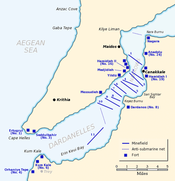
English: Map of the Dardanelles defences in February and March, 1915. The original lines of naval mines are numbered 1 to 10. The 11th line, laid in Erin Keui Bay by the minelayer Nusrat on 8 March, is numbered 11. The anti-submarine nets are shown as dotted lines. Major forts are indicated with blue boxes and the Turkish name and equivalent British number for the fort is given, if known. |
| Дата | |
| Крыніца |
Own work based on:
|
| Аўтар | Gsl |
| Дазвол (Паўторнае выкарыстанне гэтага файла) |
Released to public domain |
| Гэты твор быў перададзены ў грамадскі набытак яго аутарам, Gsl. Дазвол сапраўдны для ўсяго свету. У некаторых краінах гэта не можа быць юрыдычна магчыма; калі так, то: |
Гісторыя файла
Націснуць на даце з часам, каб паказаць файл, якім ён тады быў.
| Дата і час | Драбніца | Памеры | Удзельнік | Тлумачэнне | |
|---|---|---|---|---|---|
| актуальн. | 21:02, 21 чэрвеня 2012 | | 600 × 620 (137 KB) | Hohum | Clearer colours |
| 19:51, 22 чэрвеня 2005 |  | 600 × 620 (74 KB) | Redtony | Map of the Dardanelles defences in February and March, 1915. The original lines of naval mines are numbered 1 to 10. The 11th line, laid in Erin Keui Bay by the minelayer ''Nusrat'' on 8 March, is numbered 11. The anti-submarine nets are shown as d |
Выкарыстанне файла
Наступныя 2 старонкі выкарыстоўваюць гэты файл:
Глабальнае выкарыстанне файла
Гэты файл выкарыстоўваецца ў наступных вікі:
- Выкарыстанне ў ast.wikipedia.org
- Выкарыстанне ў be-tarask.wikipedia.org
- Выкарыстанне ў bg.wikipedia.org
- Выкарыстанне ў ca.wikipedia.org
- Выкарыстанне ў de.wikipedia.org
- Выкарыстанне ў en.wikipedia.org
- HMS Ocean (1898)
- HMS Goliath (1898)
- HMS Irresistible (1898)
- Naval operations in the Dardanelles campaign
- HMS Albion (1898)
- Lord Nelson-class battleship
- Eric Gascoigne Robinson
- French battleship Suffren
- HMS Cornwallis (1901)
- SMS Kurfürst Friedrich Wilhelm
- SMS Weissenburg
- HMS Agamemnon (1906)
- Charlemagne-class battleship
- French battleship Gaulois
- French battleship Charlemagne
- HMS Vengeance (1899)
- Dardanelles Fortified Area Command
- Gulf of Erenköy
- Ottoman minelayer Intibah
- Выкарыстанне ў es.wikipedia.org
- Выкарыстанне ў fr.wikipedia.org
- Выкарыстанне ў he.wikipedia.org
- Выкарыстанне ў it.wikipedia.org
- Выкарыстанне ў ja.wikipedia.org
- Выкарыстанне ў ka.wikipedia.org
- Выкарыстанне ў pl.wikipedia.org
- Выкарыстанне ў pt.wikipedia.org
Паказаць глабальнае выкарыстанне гэтага файла.