
Файл:Henrietta Island, Russia.jpg

Памер папярэдняга прагляду: 600 × 600 пікселяў. Іншыя разрозненні: 240 × 240 пікселяў | 480 × 480 пікселяў | 768 × 768 пікселяў | 1 024 × 1 024 пікселяў | 2 000 × 2 000 пікселяў.
Арыгінальны файл (2 000 × 2 000 кропак, аб’ём файла: 2,22 MB, тып MIME: image/jpeg)
Тлумачэнне
| Апісанне |
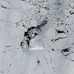
English: The Advanced Land Imager (ALI) on NASA’s Earth Observing-1 satellite captured this image of Henrietta Island. In this natural-color image, the island casts shadows to the north, thanks to the Sun’s low angle and the island’s own steep, rugged coastline. Inland, an icy dome covers most of the island, its southern surface slightly illuminated. |
| Дата | |
| Крыніца | NASA Earth Observatory |
| Аўтар | Jesse Allen |
Instrument: EO-1 - ALI
Ліцэнзіяванне
| This file is in the public domain in the United States because it was solely created by NASA. NASA copyright policy states that "NASA material is not protected by copyright unless noted". (See Template:PD-USGov, NASA copyright policy page or JPL Image Use Policy.) | ||
 |
Warnings:
|
| Annotations | This image is annotated: View the annotations at Commons |
Гісторыя файла
Націснуць на даце з часам, каб паказаць файл, якім ён тады быў.
| Дата і час | Драбніца | Памеры | Удзельнік | Тлумачэнне | |
|---|---|---|---|---|---|
| актуальн. | 14:23, 23 мая 2009 | | 2 000 × 2 000 (2,22 MB) | Originalwana | {{Information |Description={{en|1=The Advanced Land Imager (ALI) on NASA’s Earth Observing-1 satellite captured this image of Henrietta Island. In this natural-color image, the island casts shadows to the north, thanks to the Sun’s low angle and the i |
Выкарыстанне файла
Наступная 1 старонка выкарыстоўвае гэты файл:
Глабальнае выкарыстанне файла
Гэты файл выкарыстоўваецца ў наступных вікі:
- Выкарыстанне ў az.wikipedia.org
- Выкарыстанне ў de.wikipedia.org
- Выкарыстанне ў en.wikipedia.org
- Выкарыстанне ў he.wikipedia.org
- Выкарыстанне ў it.wikipedia.org
- Выкарыстанне ў ka.wikipedia.org
- Выкарыстанне ў lt.wikipedia.org
- Выкарыстанне ў mwl.wikipedia.org
- Выкарыстанне ў pl.wikipedia.org
- Выкарыстанне ў ru.wikipedia.org