
Файл:Hungarian autonomous province02.png
Памер папярэдняга прагляду: 619 × 599 пікселяў. Іншыя разрозненні: 248 × 240 пікселяў | 496 × 480 пікселяў | 751 × 727 пікселяў.
Арыгінальны файл (751 × 727 кропак, аб’ём файла: 60 KB, тып MIME: image/png)

|
This map image could be re-created using vector graphics as an SVG file. This has several advantages; see Commons:Media for cleanup for more information. If an SVG form of this image is available, please upload it and afterwards replace this template with
{{vector version available|new image name}}.
It is recommended to name the SVG file “Hungarian autonomous province02.svg”—then the template Vector version available (or Vva) does not need the new image name parameter. |
Тлумачэнне
| Апісанне |
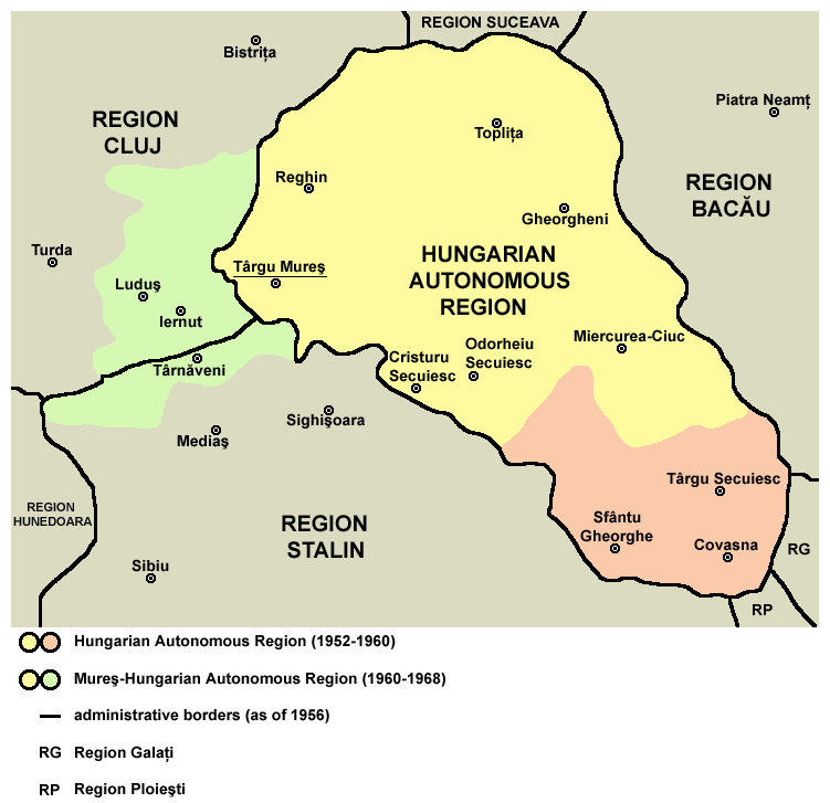
English: Map of the Hungarian Autonomous Region / Magyar Autonomous Region (1952-1960) and Mureş-Hungarian Autonomous Region / Mureş-Magyar Autonomous Region (1960-1968). |
| Дата | |
| Крыніца | Transferred from en.wikipedia |
| Аўтар | PANONIAN (размовы · уклад) |
Ліцэнзіяванне
| Я, уладальнік аўтарскіх правоў на гэты твор, перадаю яго ў грамадскі набытак. Дазвол сапраўдны для ўсяго свету. У некаторых краінах гэта не можа быць юрыдычна магчыма; калі так, то: Я дазваляю кожнаму выкарыстоўваць гэтую працу ў любых мэтах, без аніякіх умоваў, калі толькі такія ўмовы не патрабуюцца паводле закону. |

|
This map has been uploaded by Electionworld from en.wikipedia.org to enable the |
References
Primary reference:
Secondary references:
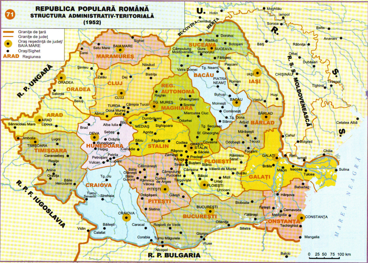
- http://www.adevarul.ro/bbtcontent/clipping/ADVIMA20110612_0443/1.jpg
- http://www.hungarian-human-rights.eu/images/rpr_1952.jpg
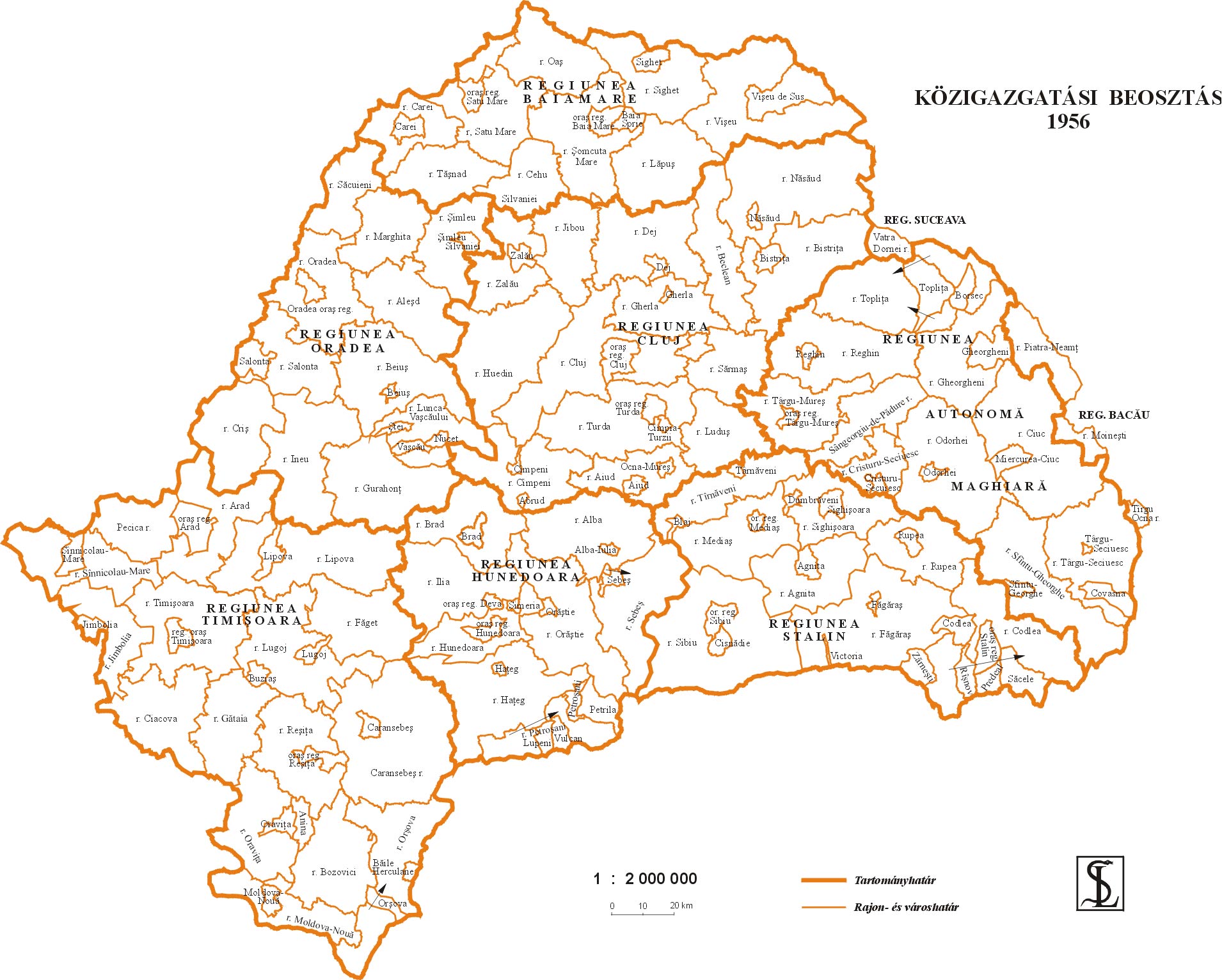
- http://sebok1.adatbank.transindex.ro/kepek/erd1956.jpg
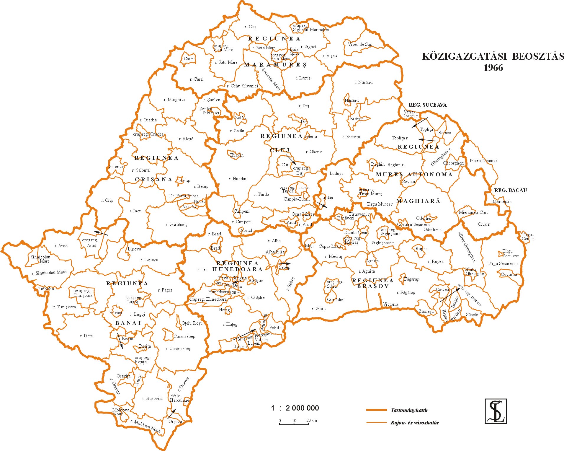
- http://sebok1.adatbank.transindex.ro/kepek/erd1966.jpg
- http://2.bp.blogspot.com/_yYcDY0o6YEA/SXaL1dSAXGI/AAAAAAAAAFk/21nu4zMSKJ8/s600/RO1960-1968.jpg
Гісторыя файла
Націснуць на даце з часам, каб паказаць файл, якім ён тады быў.
| Дата і час | Драбніца | Памеры | Удзельнік | Тлумачэнне | |
|---|---|---|---|---|---|
| актуальн. | 21:59, 26 сакавіка 2013 | | 751 × 727 (60 KB) | PANONIAN | Reverted to version as of 13:05, 24 October 2011 I do not agree with your changes, please upload your file under different name |
| 12:09, 26 сакавіка 2013 |  | 619 × 599 (103 KB) | Rgvis | Improved version with administrative borders changes shown during the existance of the Soviet-inspired administrative and territorial organisation in Communist Romania (1950-1968). | |
| 16:05, 24 кастрычніка 2011 |  | 751 × 727 (60 KB) | PANONIAN | improved version | |
| 21:56, 28 снежня 2006 |  | 716 × 620 (11 KB) | Electionworld | {{ew|en|PANONIAN}} map of the Hungarian Autonomous Province (self made) {{PD-self}} Category:Maps of the history of Romania |
Выкарыстанне файла
Наступная 1 старонка выкарыстоўвае гэты файл:
Глабальнае выкарыстанне файла
Гэты файл выкарыстоўваецца ў наступных вікі:
- Выкарыстанне ў ar.wikipedia.org
- Выкарыстанне ў bg.wikipedia.org
- Выкарыстанне ў ca.wikipedia.org
- Выкарыстанне ў en.wikipedia.org
- Выкарыстанне ў es.wikipedia.org
- Выкарыстанне ў fr.wikipedia.org
- Выкарыстанне ў hu.wikipedia.org
- Выкарыстанне ў it.wikipedia.org
- Выкарыстанне ў mk.wikipedia.org
- Выкарыстанне ў nl.wikipedia.org
- Выкарыстанне ў pl.wikipedia.org
- Выкарыстанне ў pt.wikipedia.org
- Выкарыстанне ў ro.wikipedia.org
- Выкарыстанне ў ru.wikipedia.org
- Выкарыстанне ў sl.wikipedia.org
- Выкарыстанне ў sr.wikipedia.org
- Выкарыстанне ў uk.wikipedia.org
- Выкарыстанне ў www.wikidata.org