
Файл:Millennium Island, Kiribati.jpg
Арыгінальны файл (2 832 × 4 256 кропак, аб’ём файла: 6,48 MB, тып MIME: image/jpeg)
Тлумачэнне
| Апісанне |
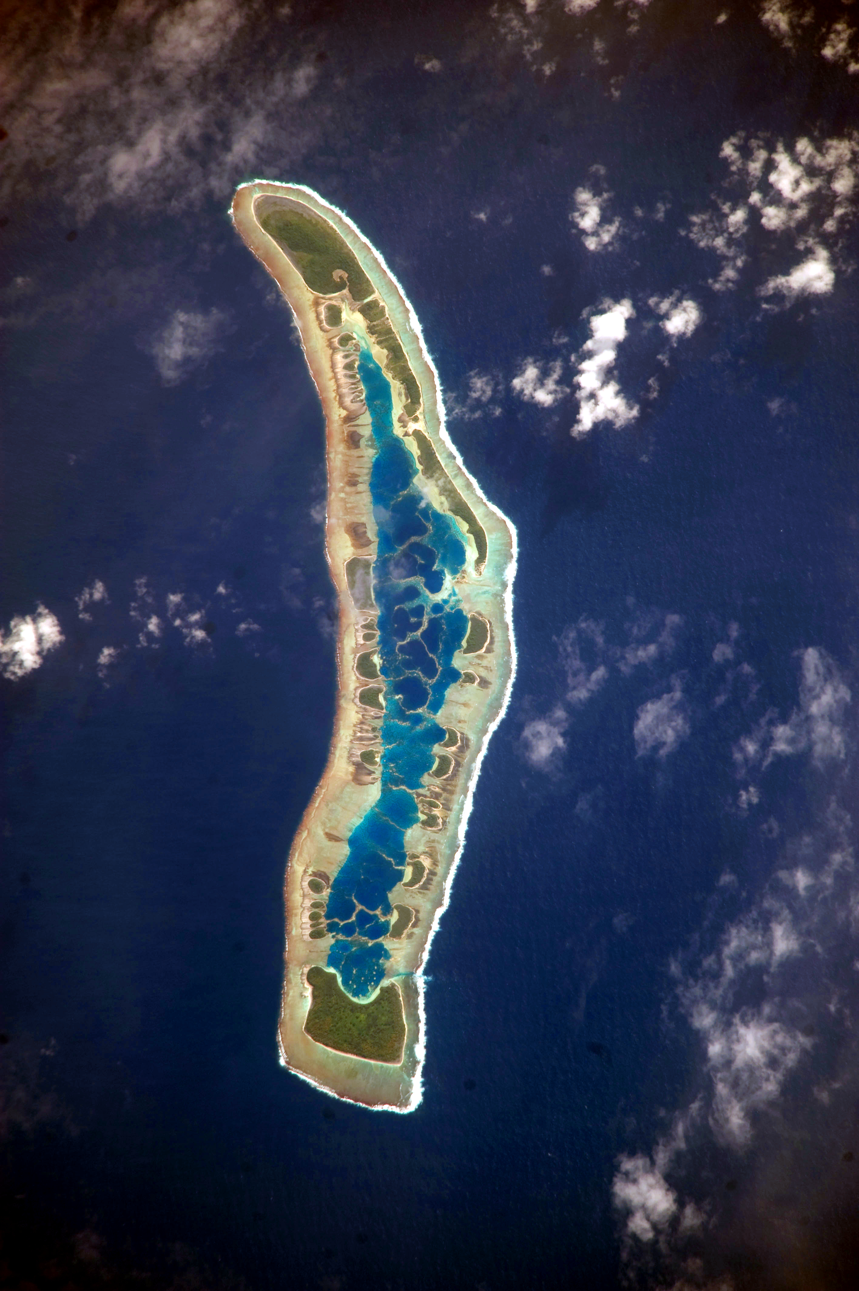
English: The islets of Millennium Island are readily visible in this astronaut photograph as irregular green vegetated areas surrounding the inner lagoon. The shallow lagoon waters are a lighter blue than the deeper surrounding ocean water; tan linear “fingers” within the lagoon are the tops of corals. The two largest islets are Nake Islet and South Islet, located at the north and south ends of Millennium Island respectively.
Français : Vue satellite de l'île du Millénaire dans les Kiribati, où l'on peut distinguer ses différents îlots, son lagon intérieur où des couleurs plus claires indiquent une profondeur plus faible ainsi que sa végétation dense sur certains îlots.
|
||||||||||||||||||||||||||||||||||||||||||||||||||||||
| Дата | |||||||||||||||||||||||||||||||||||||||||||||||||||||||
| Крыніца | NASA Earth Observatory | ||||||||||||||||||||||||||||||||||||||||||||||||||||||
| Аўтар | Image taken by the NASA Expedition 20 crew | ||||||||||||||||||||||||||||||||||||||||||||||||||||||
| Camera location | | View this and other nearby images on: OpenStreetMap |
|---|
This image or video was catalogued by Johnson Space Center of the United States National Aeronautics and Space Administration (NASA) under Photo ID: ISS020-E-16279. This tag does not indicate the copyright status of the attached work. A normal copyright tag is still required. See Commons:Licensing. Other languages:
|
This image was acquired with a Nikon D3 digital camera fitted with an 800 mm lens, and is provided by the ISS Crew Earth Observations experiment and Image Science & Analysis Laboratory, Johnson Space Center. Instrument: ISS - Digital Camera
Ліцэнзіяванне
| This file is in the public domain in the United States because it was solely created by NASA. NASA copyright policy states that "NASA material is not protected by copyright unless noted". (See Template:PD-USGov, NASA copyright policy page or JPL Image Use Policy.) | ||
 |
Warnings:
|
Гісторыя файла
Націснуць на даце з часам, каб паказаць файл, якім ён тады быў.
| Дата і час | Драбніца | Памеры | Удзельнік | Тлумачэнне | |
|---|---|---|---|---|---|
| актуальн. | 15:04, 13 чэрвеня 2017 | | 2 832 × 4 256 (6,48 MB) | SteinsplitterBot | Bot: Image rotated by 90° |
| 12:34, 5 кастрычніка 2010 |  | 4 256 × 2 832 (6,47 MB) | Originalwana | higher res | |
| 12:56, 13 ліпеня 2009 |  | 1 000 × 624 (486 KB) | Originalwana | {{Information |Description={{en|1=The islets of Millennium Island are readily visible in this astronaut photograph as irregular green vegetated areas surrounding the inner lagoon. The shallow lagoon waters are a lighter blue than the deeper surrounding oc |
Выкарыстанне файла
Наступная 1 старонка выкарыстоўвае гэты файл:
Глабальнае выкарыстанне файла
Гэты файл выкарыстоўваецца ў наступных вікі:
- Выкарыстанне ў ar.wikipedia.org
- Выкарыстанне ў ca.wikipedia.org
- Выкарыстанне ў en.wikipedia.org
- Выкарыстанне ў et.wikipedia.org
- Выкарыстанне ў fr.wikipedia.org
- Выкарыстанне ў hr.wikipedia.org
- Выкарыстанне ў id.wikipedia.org
- Выкарыстанне ў pl.wikipedia.org
- Выкарыстанне ў pt.wikipedia.org
- Выкарыстанне ў ru.wikipedia.org
- Выкарыстанне ў th.wikipedia.org
- Выкарыстанне ў tr.wikipedia.org
- Выкарыстанне ў vi.wikipedia.org