
Файл:Ottoman Empire 1914 h.PNG

Памер папярэдняга прагляду: 518 × 600 пікселяў. Іншыя разрозненні: 207 × 240 пікселяў | 415 × 480 пікселяў | 640 × 741 пікселяў.
Арыгінальны файл (640 × 741 кропак, аб’ём файла: 27 KB, тып MIME: image/png)
Тлумачэнне
| Апісанне |
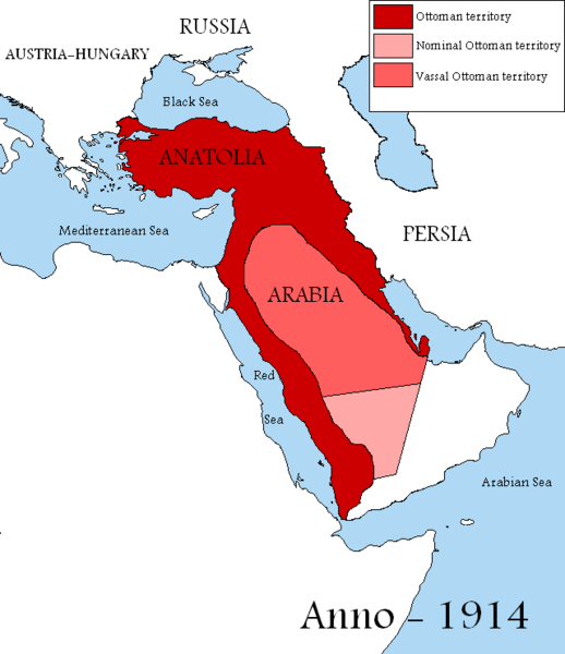
English: Map showing the territories of the Ottoman Empire in 1914, including nominal and vassal territories.
According to the information on the map in http://ottomanmilitary.devhub.com/ |
| Дата | |
| Крыніца | Уласная праца |
| Аўтар | DragonTiger23 |
| Іншыя версіі |
[]
|


Many people actually lived in this empire from time to time
Ліцэнзіяванне
| Я, уладальнік аўтарскіх правоў на гэты твор, перадаю яго ў грамадскі набытак. Дазвол сапраўдны для ўсяго свету. У некаторых краінах гэта не можа быць юрыдычна магчыма; калі так, то: Я дазваляю кожнаму выкарыстоўваць гэтую працу ў любых мэтах, без аніякіх умоваў, калі толькі такія ўмовы не патрабуюцца паводле закону. |

|
This historical map image could be re-created using vector graphics as an SVG file. This has several advantages; see Commons:Media for cleanup for more information. If an SVG form of this image is available, please upload it and afterwards replace this template with
{{vector version available|new image name}}.
It is recommended to name the SVG file “Ottoman Empire 1914 h.svg”—then the template Vector version available (or Vva) does not need the new image name parameter. |
Гісторыя файла
Націснуць на даце з часам, каб паказаць файл, якім ён тады быў.
| Дата і час | Драбніца | Памеры | Удзельнік | Тлумачэнне | |
|---|---|---|---|---|---|
| актуальн. | 16:04, 29 жніўня 2019 | | 640 × 741 (27 KB) | Aybeg | Cyprus was under British control. |
| 17:20, 28 жніўня 2019 |  | 640 × 741 (27 KB) | Aybeg | In 1914, the Ottomans did not rule over Egypt and Sudan. | |
| 16:03, 13 студзеня 2011 |  | 640 × 741 (33 KB) | DragonTiger23 | {{Information |Description={{en|1=Map showing the territories of the Ottoman Empire in 1914, including nominal and vassal territories. According to the information on the map in http://ottomanmilitary.devhub.com/}} |Source={{own}} |Author=[[User:DragonTi |
Выкарыстанне файла
Наступная 1 старонка выкарыстоўвае гэты файл:
Глабальнае выкарыстанне файла
Гэты файл выкарыстоўваецца ў наступных вікі:
- Выкарыстанне ў ar.wikipedia.org
- Выкарыстанне ў bg.wikipedia.org
- Выкарыстанне ў en.wikipedia.org
- Выкарыстанне ў fr.wikipedia.org
- Выкарыстанне ў he.wikipedia.org
- Выкарыстанне ў hu.wikipedia.org
- Выкарыстанне ў it.wikipedia.org
- Выкарыстанне ў nl.wikipedia.org
- Выкарыстанне ў pt.wikipedia.org