
Файл:Ugandan districts affected by Lords Resistance Army.png

Памер папярэдняга прагляду: 486 × 599 пікселяў. Іншыя разрозненні: 195 × 240 пікселяў | 596 × 735 пікселяў.
Арыгінальны файл (596 × 735 кропак, аб’ём файла: 92 KB, тып MIME: image/png)

|
This military map image could be re-created using vector graphics as an SVG file. This has several advantages; see Commons:Media for cleanup for more information. If an SVG form of this image is available, please upload it and afterwards replace this template with
{{vector version available|new image name}}.
It is recommended to name the SVG file “Ugandan districts affected by Lords Resistance Army.svg”—then the template Vector version available (or Vva) does not need the new image name parameter. |
Тлумачэнне
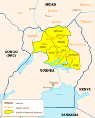
Sources used to draw this map
- Maps in USAID/RLP (2004) Refugee Law Project Working Paper No. 11 ( online version)
- IDP Project maps (Uganda, Sudan
- UN Department of Public Information, Map no. 3862.1 (september 2002), Ugandan district boundaries
- Wikipedia article onLRA
Гэты файл даступны па ліцэнзіі Creative Commons Пазначэнне аўтарства 2.5 Агульны
- Вы можаце свабодна:
- дзяліцца творам – капіраваць, распаўсюджваць і перадаваць гэты твор.
- ствараць вытворныя творы – адаптаваць гэты твор
- Пры выкананні наступных умоў:
- атрыбуцыя – вы павінны пазначыць аўтарства гэтага твора, даць спасылку на ліцэнзію і пазначыць ці рабіў аўтар якія-небудзь змены. Гэта можна рабіць кожным зразумелым чынам, але не так, каб наводзіць па думку, што ліцэнзіят падтрымлівае вас або выкарыстанне вамі гэтага твора.
This image was created by Mark Dingemanse and released under the Creative Commons Attribution 2.5 license. The image and any derivatives should be attributed to its creator (Mark Dingemanse) and/or to his agency (vormdicht); if you choose the latter, please provide a link to www.vormdicht.nl. Feel free to notify me when you're using one of my images outside of the Wikimedia projects; that way, I'll be able to let you know when I release an updated version.
Гісторыя файла
Націснуць на даце з часам, каб паказаць файл, якім ён тады быў.
| Дата і час | Драбніца | Памеры | Удзельнік | Тлумачэнне | |
|---|---|---|---|---|---|
| актуальн. | 20:35, 6 красавіка 2012 | | 596 × 735 (92 KB) | Ras67 | cropped |
| 21:08, 20 сакавіка 2012 |  | 600 × 739 (91 KB) | Hoshie | Reverted to version as of 00:37, 22 February 2008: The data the map is based on is before S. Sudan succeeded - sorry for the mixup. | |
| 06:21, 9 сакавіка 2012 |  | 600 × 739 (142 KB) | Hoshie | updated to include South Sudan; I tried to get the font to match. | |
| 03:37, 22 лютага 2008 |  | 600 × 739 (91 KB) | Mahahahaneapneap | pngcrushed | |
| 17:10, 29 снежня 2004 |  | 600 × 739 (97 KB) | M. Dingemanse | new version: few layout fixes, cleaned up superfluous cities, enlarged text | |
| 01:37, 27 снежня 2004 |  | 600 × 739 (106 KB) | M. Dingemanse | Ugandan districts affected by Lord's Resistance Army - created by Mark Dingemanse - {{cc-by-2.0}} |
Выкарыстанне файла
Наступная 1 старонка выкарыстоўвае гэты файл:
Глабальнае выкарыстанне файла
Гэты файл выкарыстоўваецца ў наступных вікі:
- Выкарыстанне ў af.wikipedia.org
- Выкарыстанне ў de.wikipedia.org
- Выкарыстанне ў en.wikipedia.org
- Lord's Resistance Army insurgency
- Holy Spirit Movement
- Alice Auma
- Portal:Africa/Featured article
- Lord's Resistance Army insurgency (1987–1994)
- Lord's Resistance Army insurgency (1994–2002)
- Template:Lord's Resistance Army
- Lord's Resistance Army insurgency (2002–2005)
- 2006–2008 Juba talks
- Julius Achon
- Portal:Africa/Featured article/5
- Lord's Resistance Army
- 2008–2009 Garamba offensive
- 2008 Christmas massacres
- Makombo massacre
- International Criminal Court investigation in Uganda
- Kony 2012
- User talk:M. Dingemanse/Archive16
- User:Huntersgordon/sandbox
- Refugees of Uganda
- War in Uganda (1986–1994)
- Wikipedia:In the news/Posted/October 2005
- Выкарыстанне ў en.wikinews.org
- Выкарыстанне ў es.wikipedia.org
- Выкарыстанне ў fa.wikipedia.org
- Выкарыстанне ў fi.wikipedia.org
- Выкарыстанне ў fr.wikipedia.org
- Выкарыстанне ў fr.wikinews.org
- Выкарыстанне ў hu.wikipedia.org
- Выкарыстанне ў ja.wikipedia.org
- Выкарыстанне ў ko.wikipedia.org
- Выкарыстанне ў lg.wikipedia.org
- Выкарыстанне ў pl.wikipedia.org
- Выкарыстанне ў pl.wikinews.org
Паказаць глабальнае выкарыстанне гэтага файла.