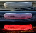
Файл:Allianz Arena zu verschiedenen Zeiten.jpg
Appearance

Памер папярэдняга прагляду: 651 × 600 пікселяў. Іншыя разрозненні: 260 × 240 пікселяў | 521 × 480 пікселяў | 833 × 768 пікселяў | 1 111 × 1 024 пікселяў | 2 222 × 2 048 пікселяў | 4 811 × 4 434 пікселяў.
Арыгінальны файл (4 811 × 4 434 кропак, аб’ём файла: 4,57 MB, тып MIME: image/jpeg)
Гісторыя файла
Націснуць на даце з часам, каб паказаць файл, якім ён тады быў.
| Дата і час | Драбніца | Памеры | Удзельнік | Тлумачэнне | |
|---|---|---|---|---|---|
| актуальн. | 19:31, 22 красавіка 2008 |  | 4 811 × 4 434 (4,57 MB) | Niabot | more contrast |
| 19:10, 19 красавіка 2008 |  | 4 811 × 4 434 (4,41 MB) | Niabot | Border reduced | |
| 21:18, 18 красавіка 2008 |  | 5 200 × 5 000 (4,52 MB) | Niabot | Verbesserte Version (Ausrichtung, Rahmen entfernt) | |
| 12:17, 18 красавіка 2008 |  | 5 200 × 5 000 (3,08 MB) | Niabot | {{Information |Description = {{de|Ein Zusammenstellung von Bilder der Allianz-Arena, zu unterschiedlichen Tageszeiten. Die Allianz-Arena (Eigenschreibweise: Allianz Arena) ist ein Fußballstadion an der Werner-Heisenberg-Allee im Norden von München. In d |
Выкарыстанне файла
Няма старонак, якія выкарыстоўваюць гэты файл.
Глабальнае выкарыстанне файла
Гэты файл выкарыстоўваецца ў наступных вікі:
- Выкарыстанне ў ba.wikipedia.org
- Выкарыстанне ў da.wikipedia.org
- Выкарыстанне ў de.wikipedia.org
- München
- Portal:Architektur und Bauwesen/titelbild/archiv
- Portal:Architektur und Bauwesen/Ausgezeichnete Darstellungen
- Benutzer:Smial/spielwiese
- Geschichte der Leuchtreklame in Deutschland
- Wikipedia:Exzellente Bilder/Kunst und Kultur
- Wikipedia:Kandidaten für exzellente Bilder/Archiv2008/7
- Wikipedia:Kandidaten für exzellente Bilder/Archiv2008/8
- Datei:Allianz Arena zu verschiedenen Zeiten.jpg
- Wikipedia:Kandidaten für exzellente Bilder/Archiv2009/3
- Portal:München/Prämiertes/Bilder
- Hilfe Diskussion:Bilder/Kollagen und Mehrfachbilder
- Выкарыстанне ў el.wikipedia.org
- Выкарыстанне ў en.wikipedia.org
- Выкарыстанне ў fa.wikipedia.org
- Выкарыстанне ў fr.wikipedia.org
- Выкарыстанне ў ga.wikipedia.org
- Выкарыстанне ў gl.wikipedia.org
- Выкарыстанне ў hr.wikipedia.org
- Выкарыстанне ў hu.wikipedia.org
- Выкарыстанне ў hy.wikipedia.org
- Выкарыстанне ў ja.wikipedia.org
- Выкарыстанне ў kk.wikipedia.org
- Выкарыстанне ў mk.wikipedia.org
- Выкарыстанне ў mr.wikipedia.org
- Выкарыстанне ў pl.wikipedia.org
- Выкарыстанне ў pt.wikipedia.org
- Выкарыстанне ў rm.wikipedia.org
- Выкарыстанне ў ru.wikipedia.org
- Выкарыстанне ў sk.wikipedia.org
- Выкарыстанне ў sv.wikipedia.org
Паказаць глабальнае выкарыстанне гэтага файла.

