
Файл:GulfofMaine.jpg
Няма версіі з большай раздзяляльнасцю.
GulfofMaine.jpg (523 × 544 кропак, аб’ём файла: 285 KB, тып MIME: image/jpeg)
Origin
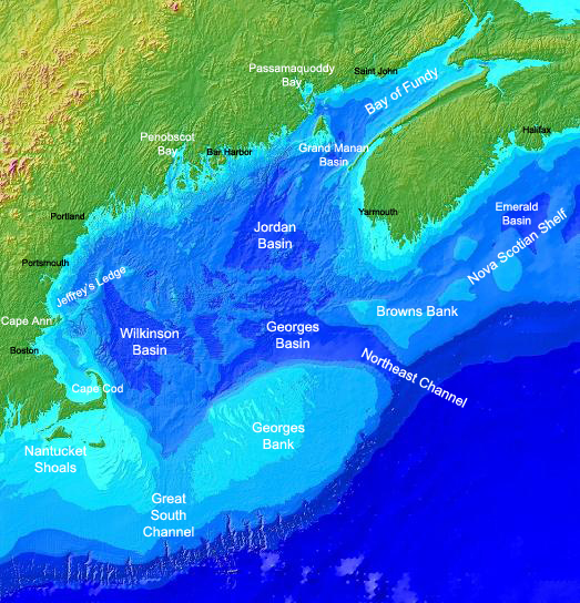
Found on the english Wikipedia Image :GulfofMaine.jpg. Digital bathymetry map of the Gulf of Maine. Credit: National Oceanographic and Atmospheric Administration and U.S. Geological Survey (USGS) Woods Hole, MA Labels by Syagria.)
Тлумачэнне
Digital bathymetry map of the Gulf of Maine. Credit: National Oceanographic and Atmospheric Administration and U.S. Geological Survey (USGS) Woods Hole, MA. Labels by Syagria.
Ліцэнзіяванне
This image is in the public domain because it contains materials that originally came from the U.S. National Oceanic and Atmospheric Administration, taken or made as part of an employee's official duties.
|
Гісторыя файла
Націснуць на даце з часам, каб паказаць файл, якім ён тады быў.
| Дата і час | Драбніца | Памеры | Удзельнік | Тлумачэнне | |
|---|---|---|---|---|---|
| актуальн. | 03:32, 27 лістапада 2006 | | 523 × 544 (285 KB) | TCY | ==Origin== Found on the english Wikipedia [http://en.wikipedia.org/wiki/Image:GulfofMaine.jpg Image :GulfofMaine.jpg] == Summary == Digital bathymetry map of the Gulf of Maine. Credit: National Oceanographic and Atmospheric Administration and U.S. Geolog |
Выкарыстанне файла
Наступная 1 старонка выкарыстоўвае гэты файл:
Глабальнае выкарыстанне файла
Гэты файл выкарыстоўваецца ў наступных вікі:
- Выкарыстанне ў az.wikipedia.org
- Выкарыстанне ў bg.wikipedia.org
- Выкарыстанне ў ca.wikipedia.org
- Выкарыстанне ў ce.wikipedia.org
- Выкарыстанне ў da.wikipedia.org
- Выкарыстанне ў en.wikipedia.org
- Выкарыстанне ў en.wikiversity.org
- Выкарыстанне ў es.wikipedia.org
- Выкарыстанне ў eu.wikipedia.org
- Выкарыстанне ў fa.wikipedia.org
- Выкарыстанне ў fi.wikipedia.org
- Выкарыстанне ў fr.wikipedia.org
- Выкарыстанне ў gl.wikipedia.org
- Выкарыстанне ў hr.wikipedia.org
- Выкарыстанне ў id.wikipedia.org
- Выкарыстанне ў is.wikipedia.org
- Выкарыстанне ў ka.wikipedia.org
- Выкарыстанне ў ko.wikipedia.org
- Выкарыстанне ў lt.wikipedia.org
- Выкарыстанне ў ml.wikipedia.org
- Выкарыстанне ў pt.wikipedia.org
- Выкарыстанне ў ru.wikipedia.org
- Выкарыстанне ў ta.wikipedia.org
- Выкарыстанне ў zh.wikipedia.org